Unicoi Topo Map Tennessee
To zoom in, hover over the map of Unicoi
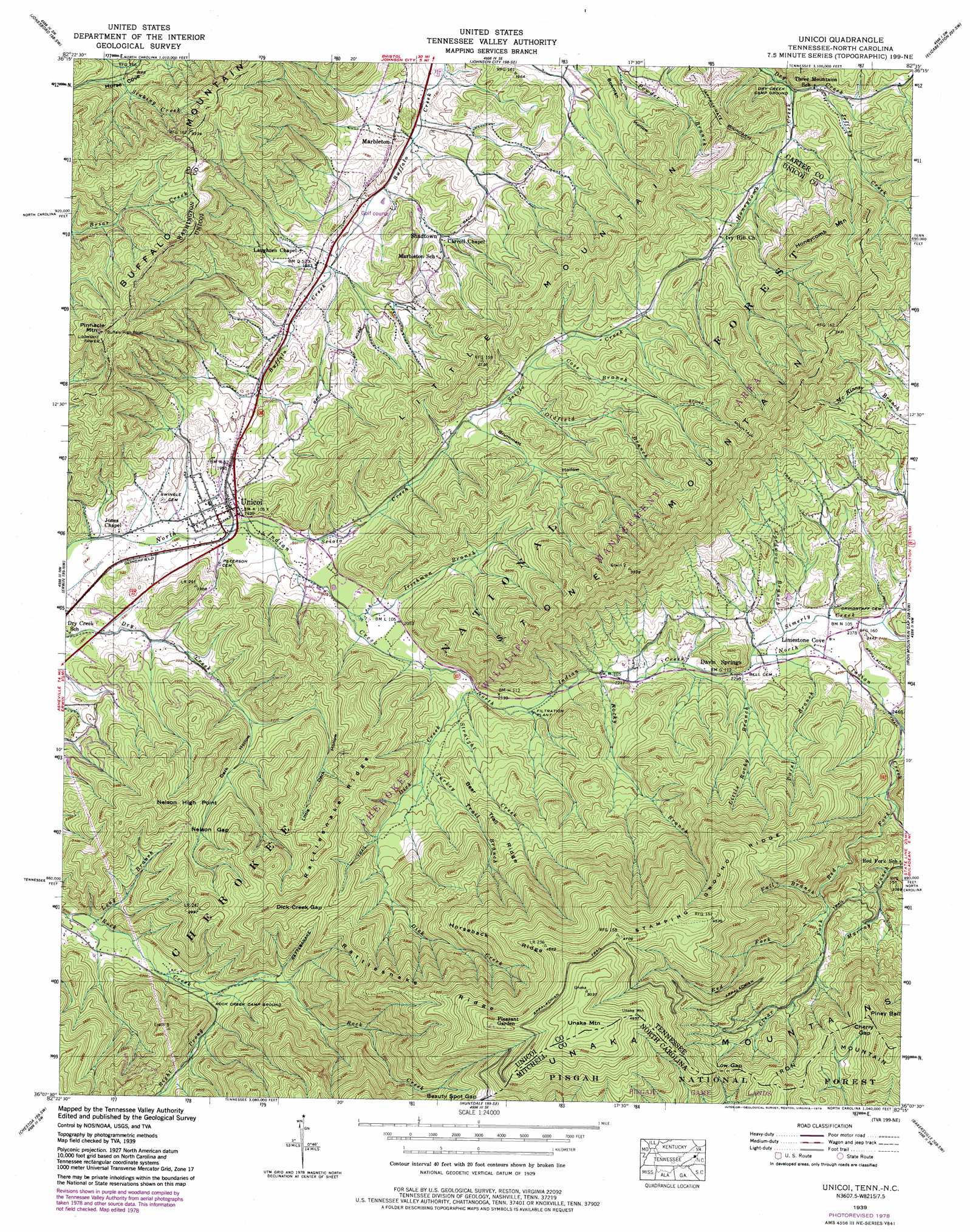
USGS Topo Quad 36082b3 - 1:24,000 scale
| Topo Map Name: | Unicoi |
| USGS Topo Quad ID: | 36082b3 |
| Print Size: | ca. 21 1/4" wide x 27" high |
| Southeast Coordinates: | 36.125° N latitude / 82.25° W longitude |
| Map Center Coordinates: | 36.1875° N latitude / 82.3125° W longitude |
| U.S. States: | TN, NC |
| Filename: | o36082b3.jpg |
| Download Map JPG Image: | Unicoi topo map 1:24,000 scale |
| Map Type: | Topographic |
| Topo Series: | 7.5´ |
| Map Scale: | 1:24,000 |
| Source of Map Images: | United States Geological Survey (USGS) |
| Alternate Map Versions: |
Unicoi TN 1935 Download PDF Buy paper map Unicoi TN 1939 Download PDF Buy paper map Unicoi TN 1939, updated 1954 Download PDF Buy paper map Unicoi TN 1939, updated 1973 Download PDF Buy paper map Unicoi TN 1939, updated 1979 Download PDF Buy paper map Unicoi TN 2003 Download PDF Buy paper map Unicoi TN 2011 Download PDF Buy paper map Unicoi TN 2013 Download PDF Buy paper map Unicoi TN 2016 Download PDF Buy paper map |
| FStopo: | US Forest Service topo Unicoi is available: Download FStopo PDF Download FStopo TIF |
1:24,000 Topo Quads surrounding Unicoi
Sullivan Gardens |
Boone Dam |
Bluff City |
Keenburg |
Carter |
Leesburg |
Jonesboro |
Johnson City |
Elizabethton |
Watauga Dam |
Telford |
Erwin |
Unicoi |
Iron Mountain Gap |
White Rocks Mountain |
Flag Pond |
Chestoa |
Huntdale |
Bakersville |
Carvers Gap |
Sams Gap |
Bald Creek |
Burnsville |
Micaville |
Spruce Pine |
> Back to 36082a1 at 1:100,000 scale
> Back to 36082a1 at 1:250,000 scale
> Back to U.S. Topo Maps home
Unicoi topo map: Gazetteer
Unicoi: Airports
Appalachian Flying Service Number One Airport elevation 698m 2290′Unicoi: Gaps
Beauty Spot Gap elevation 1256m 4120′Cherry Gap elevation 1227m 4025′
Cherry Gap elevation 1216m 3989′
Dick Creek Gap elevation 867m 2844′
Dick Creek Gap elevation 1003m 3290′
Low Gap elevation 1192m 3910′
Low Gap elevation 1175m 3854′
Nelson Gap elevation 775m 2542′
Nelson Gap elevation 785m 2575′
Unicoi: Mines
Britt Mine elevation 669m 2194′Gaddy Prospect elevation 621m 2037′
Head Prospect elevation 680m 2230′
John Brummett Mine elevation 702m 2303′
Jones Mine elevation 606m 1988′
Sam Brummett Mine elevation 766m 2513′
Street Mine elevation 642m 2106′
Tipton Prospect elevation 631m 2070′
Unicoi Mine elevation 682m 2237′
Unicoi Prospect elevation 691m 2267′
Unicoi: Parks
Limestone Cove Recreation Area elevation 679m 2227′Unaka Mountain Recreation Area elevation 1438m 4717′
Unicoi: Populated Places
Davis Springs elevation 698m 2290′Limestone Cove elevation 726m 2381′
Marbleton elevation 556m 1824′
Pleasant Garden elevation 1479m 4852′
Shadtown elevation 584m 1916′
Three Mountains elevation 608m 1994′
Unicoi elevation 586m 1922′
Whispering Pines elevation 642m 2106′
Unicoi: Ranges
Little Mountain elevation 755m 2477′Stone Mountain elevation 990m 3248′
Unicoi: Ridges
Bear Trail Ridge elevation 832m 2729′Bear Trail Ridge elevation 892m 2926′
Horseback Ridge elevation 1278m 4192′
Horseback Ridge elevation 1285m 4215′
Rattlesnake Ridge elevation 1031m 3382′
Rattlesnake Ridge elevation 867m 2844′
Rattlesnake Ridge elevation 1235m 4051′
Stamping Ground Ridge elevation 1288m 4225′
Stamping Ground Ridge elevation 1295m 4248′
Unicoi: Springs
Davis Springs elevation 700m 2296′Unicoi: Streams
Clear Fork elevation 943m 3093′Cordwood Branch elevation 713m 2339′
Cordwood Branch elevation 713m 2339′
Cove Branch elevation 679m 2227′
Cove Branch elevation 680m 2230′
Dick Creek elevation 647m 2122′
Dick Creek elevation 646m 2119′
Fall Branch elevation 894m 2933′
Fall Branch elevation 978m 3208′
Honeycomb Creek elevation 586m 1922′
Honeycomb Creek elevation 633m 2076′
Indian Creek elevation 780m 2559′
Irishman Branch elevation 612m 2007′
Irishman Branch elevation 614m 2014′
Jeffrey Creek elevation 605m 1984′
Jeffrey Creek elevation 601m 1971′
Little Rocky Branch elevation 699m 2293′
Long Branch elevation 612m 2007′
Long Branch elevation 619m 2030′
Oldfield Branch elevation 658m 2158′
Oldfield Branch elevation 655m 2148′
Paint Branch elevation 701m 2299′
Paint Branch elevation 700m 2296′
Red Fork elevation 787m 2582′
Red Fork elevation 786m 2578′
Right Prong Rock Creek elevation 681m 2234′
Right Prong Rock Creek elevation 677m 2221′
Rocky Branch elevation 671m 2201′
Rocky Branch elevation 670m 2198′
Scioto Creek elevation 585m 1919′
Scioto Creek elevation 585m 1919′
Straight Creek elevation 661m 2168′
Straight Creek elevation 659m 2162′
Turkey Trail Branch elevation 694m 2276′
Turkey Trail Branch elevation 695m 2280′
Unicoi: Summits
Big Ball elevation 1254m 4114′Big Ball elevation 1254m 4114′
Buffalo Mountain elevation 1048m 3438′
Honeycomb Mountain elevation 935m 3067′
Honeycomb Mountain elevation 928m 3044′
Little Mountain elevation 742m 2434′
Nelson High Point elevation 852m 2795′
Piney Ball elevation 1281m 4202′
Piney Ball elevation 1288m 4225′
Pinnacle Mountain elevation 1057m 3467′
Pinnacle Mountain elevation 1079m 3540′
Stone Mountain elevation 1129m 3704′
Unaka Mountain elevation 1579m 5180′
Unicoi: Trails
Hemlock Forest Trail elevation 685m 2247′Limestone Cove Trail elevation 755m 2477′
Little Dark Hollow Trail elevation 806m 2644′
Pinnacle Tower Trail elevation 958m 3143′
Rattlesnake Ridge Trail elevation 785m 2575′
Rattlesnake Trail elevation 774m 2539′
Ravens Lore Trail elevation 1471m 4826′
Red Fork Falls Trail elevation 950m 3116′
Rock Creek Bicycle Trail elevation 687m 2253′
Rock Creek Falls Trail elevation 766m 2513′
Stamping Ground Trail elevation 1062m 3484′
Unaka Mountain Scenic Trail elevation 1395m 4576′
Unicoi: Valleys
Brummett Hollow elevation 663m 2175′Dark Hollow elevation 675m 2214′
Dark Hollow elevation 646m 2119′
Little Dark Hollow elevation 716m 2349′
Little Dark Hollow elevation 653m 2142′
Sugar Hollow elevation 622m 2040′
Unicoi digital topo map on disk
Buy this Unicoi topo map showing relief, roads, GPS coordinates and other geographical features, as a high-resolution digital map file on DVD:
Western Virginia & Southern West Virginia
Buy digital topo maps: Western Virginia & Southern West Virginia