Baxter Topo Map Tennessee
To zoom in, hover over the map of Baxter
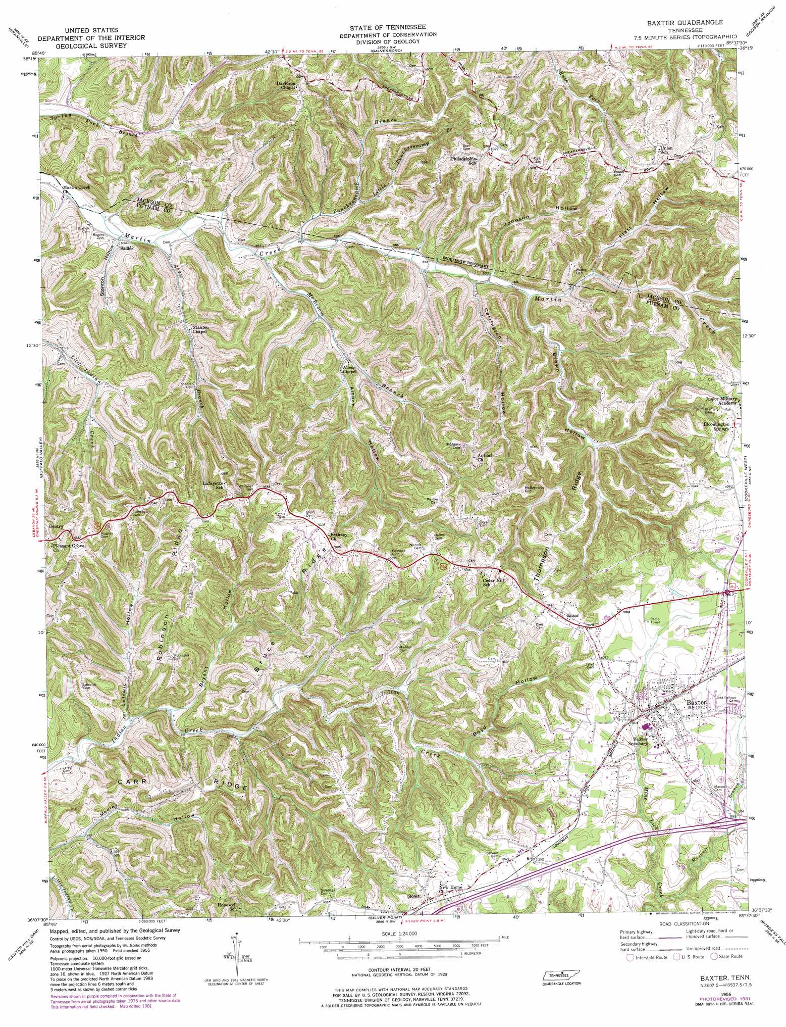
USGS Topo Quad 36085b6 - 1:24,000 scale
| Topo Map Name: | Baxter |
| USGS Topo Quad ID: | 36085b6 |
| Print Size: | ca. 21 1/4" wide x 27" high |
| Southeast Coordinates: | 36.125° N latitude / 85.625° W longitude |
| Map Center Coordinates: | 36.1875° N latitude / 85.6875° W longitude |
| U.S. State: | TN |
| Filename: | o36085b6.jpg |
| Download Map JPG Image: | Baxter topo map 1:24,000 scale |
| Map Type: | Topographic |
| Topo Series: | 7.5´ |
| Map Scale: | 1:24,000 |
| Source of Map Images: | United States Geological Survey (USGS) |
| Alternate Map Versions: |
Baxter TN 1955, updated 1956 Download PDF Buy paper map Baxter TN 1955, updated 1975 Download PDF Buy paper map Baxter TN 1955, updated 1981 Download PDF Buy paper map Baxter TN 2010 Download PDF Buy paper map Baxter TN 2013 Download PDF Buy paper map Baxter TN 2016 Download PDF Buy paper map |
1:24,000 Topo Quads surrounding Baxter
Pleasant Shade |
Willette |
Whitleyville |
Burristown |
Hilham |
Carthage |
Granville |
Gainesboro |
Dodson Branch |
Windle |
Gordonsville |
Buffalo Valley |
Baxter |
Cookeville West |
Cookeville East |
Liberty |
Center Hill Dam |
Silver Point |
Burgess Falls |
Dry Valley |
Gassaway |
Smithville |
Sligo Bridge |
Cassville |
Sparta |
> Back to 36085a1 at 1:100,000 scale
> Back to 36084a1 at 1:250,000 scale
> Back to U.S. Topo Maps home
Baxter topo map: Gazetteer
Baxter: Crossings
Interchange 280 elevation 297m 974′Baxter: Dams
Wayland Lake Dam elevation 306m 1003′Baxter: Populated Places
Baxter elevation 313m 1026′Boma elevation 321m 1053′
Cedar Hill elevation 324m 1062′
Ensor elevation 323m 1059′
Gentry elevation 309m 1013′
Ivy Gap (historical) elevation 308m 1010′
Lafayette elevation 303m 994′
Sadler elevation 163m 534′
Union Hill elevation 302m 990′
Baxter: Post Offices
Baxter Post Office elevation 319m 1046′Baxter: Reservoirs
Wayland Lake elevation 306m 1003′Baxter: Ridges
Brown Ridge elevation 318m 1043′Bruce Ridge elevation 307m 1007′
Bryant Ridge elevation 285m 935′
Carr Ridge elevation 307m 1007′
Dyer Ridge elevation 306m 1003′
Goolsby Ridge elevation 312m 1023′
Robinson Ridge elevation 311m 1020′
Thompson Ridge elevation 323m 1059′
Baxter: Streams
Alcorn Hollow Branch elevation 197m 646′Boyd Hollow Branch elevation 223m 731′
Brown Hollow Branch elevation 187m 613′
Bryant Hollow Branch elevation 168m 551′
Leftwich Hollow Branch elevation 168m 551′
Little Puncheoncamp Branch elevation 185m 606′
Maxwell Branch elevation 268m 879′
McBroom Branch elevation 173m 567′
Puncheoncamp Branch elevation 173m 567′
Shaw Branch elevation 163m 534′
Baxter: Valleys
Alcorn Hollow elevation 183m 600′Boyd Hollow elevation 223m 731′
Brown Hollow elevation 187m 613′
Bryant Hollow elevation 168m 551′
Carrington Hollow elevation 182m 597′
Flatt Hollow elevation 193m 633′
Hatfield Hollow elevation 197m 646′
Johnson Hollow elevation 183m 600′
Leftwich Hollow elevation 168m 551′
Stanton Hollow elevation 162m 531′
Baxter digital topo map on disk
Buy this Baxter topo map showing relief, roads, GPS coordinates and other geographical features, as a high-resolution digital map file on DVD: