Center Hill Dam Topo Map Tennessee
To zoom in, hover over the map of Center Hill Dam
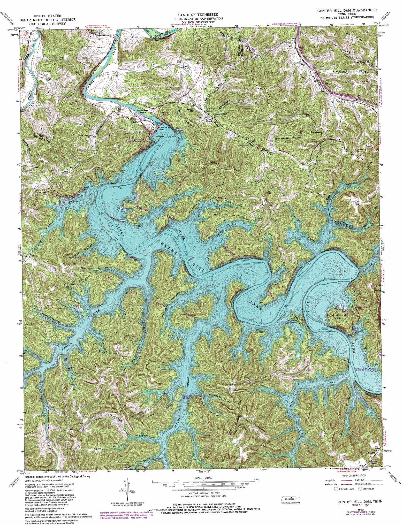
USGS Topo Quad 36085a7 - 1:24,000 scale
| Topo Map Name: | Center Hill Dam |
| USGS Topo Quad ID: | 36085a7 |
| Print Size: | ca. 21 1/4" wide x 27" high |
| Southeast Coordinates: | 36° N latitude / 85.75° W longitude |
| Map Center Coordinates: | 36.0625° N latitude / 85.8125° W longitude |
| U.S. State: | TN |
| Filename: | o36085a7.jpg |
| Download Map JPG Image: | Center Hill Dam topo map 1:24,000 scale |
| Map Type: | Topographic |
| Topo Series: | 7.5´ |
| Map Scale: | 1:24,000 |
| Source of Map Images: | United States Geological Survey (USGS) |
| Alternate Map Versions: |
Center Hill Dam TN 1962, updated 1964 Download PDF Buy paper map Center Hill Dam TN 1962, updated 1972 Download PDF Buy paper map Center Hill Dam TN 1962, updated 1980 Download PDF Buy paper map Center Hill Dam TN 1962, updated 1986 Download PDF Buy paper map Center Hill Dam TN 2010 Download PDF Buy paper map Center Hill Dam TN 2013 Download PDF Buy paper map Center Hill Dam TN 2016 Download PDF Buy paper map |
1:24,000 Topo Quads surrounding Center Hill Dam
Dixon Springs |
Carthage |
Granville |
Gainesboro |
Dodson Branch |
New Middleton |
Gordonsville |
Buffalo Valley |
Baxter |
Cookeville West |
Alexandria |
Liberty |
Center Hill Dam |
Silver Point |
Burgess Falls |
Auburntown |
Gassaway |
Smithville |
Sligo Bridge |
Cassville |
Woodbury |
Short Mountain |
Dibrell |
Campaign |
Doyle |
> Back to 36085a1 at 1:100,000 scale
> Back to 36084a1 at 1:250,000 scale
> Back to U.S. Topo Maps home
Center Hill Dam topo map: Gazetteer
Center Hill Dam: Crossings
Greenmoss Ferry (historical) elevation 197m 646′Loves Ferry (historical) elevation 197m 646′
Center Hill Dam: Dams
Center Hill Dam elevation 212m 695′Center Hill Dam: Islands
Wolf Creek Island elevation 145m 475′Center Hill Dam: Parks
Buffalo Valley Recreation Area elevation 145m 475′Center Hill Recreation Area elevation 214m 702′
Cove Hollow Recreation Area elevation 212m 695′
Edgar Evins State Rustic Park elevation 246m 807′
Floating Mill Park elevation 223m 731′
Holmes Creek Recreation Area elevation 222m 728′
Hurricane Bridge Recreation Area elevation 201m 659′
Long Branch Recreation Area elevation 159m 521′
Center Hill Dam: Populated Places
Buckner elevation 318m 1043′Laurel Hill elevation 165m 541′
Center Hill Dam: Reservoirs
Center Hill Lake elevation 212m 695′Center Hill Dam: Ridges
Maggard Ridge elevation 313m 1026′Moss Ridge elevation 307m 1007′
Tucker Ridge elevation 311m 1020′
Wallace Ridge elevation 320m 1049′
Center Hill Dam: Streams
Big Hurricane Creek elevation 197m 646′Camp Branch elevation 197m 646′
Florida Branch elevation 197m 646′
Hale Branch elevation 197m 646′
Holmes Creek elevation 197m 646′
Indian Creek elevation 197m 646′
Jones Fork elevation 197m 646′
Lick Branch elevation 197m 646′
Little Hurricane Creek elevation 197m 646′
Long Branch elevation 153m 501′
Mill Branch elevation 197m 646′
Second Creek elevation 197m 646′
Wolf Creek elevation 145m 475′
Center Hill Dam: Valleys
Atnip Hollow elevation 197m 646′Buckeye Hollow elevation 197m 646′
Christian Hollow elevation 166m 544′
Cobb Hollow elevation 197m 646′
Cove Hollow elevation 197m 646′
Fuston Hollow elevation 197m 646′
Hames Hollow elevation 197m 646′
Hellum Hollow elevation 184m 603′
Huddleson Hollow elevation 189m 620′
Merritt Hollow elevation 197m 646′
Moss Hollow elevation 160m 524′
Mullican Hollow elevation 197m 646′
Poison Hollow elevation 197m 646′
Raccoon Hollow elevation 197m 646′
Smith Hollow elevation 164m 538′
Stillhouse Hollow elevation 197m 646′
Wallace Hollow elevation 198m 649′
Wildcat Hollow elevation 197m 646′
Center Hill Dam digital topo map on disk
Buy this Center Hill Dam topo map showing relief, roads, GPS coordinates and other geographical features, as a high-resolution digital map file on DVD: