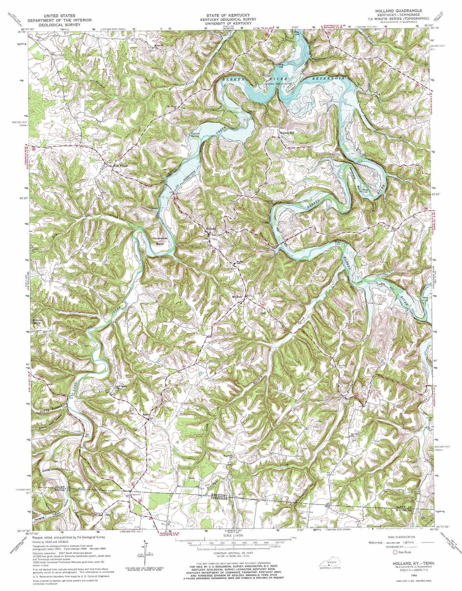
Holland Topo Map Kentucky
To zoom in, hover over the map of Holland
USGS Topo Quad 36086f1 - 1:24,000 scale
| Topo Map Name: | Holland |
| USGS Topo Quad ID: | 36086f1 |
| Print Size: | ca. 21 1/4" wide x 27" high |
| Southeast Coordinates: | 36.625° N latitude / 86° W longitude |
| Map Center Coordinates: | 36.6875° N latitude / 86.0625° W longitude |
| U.S. States: | KY, TN |
| Filename: | o36086f1.jpg |
| Download Map JPG Image: | Holland topo map 1:24,000 scale |
| Map Type: | Topographic |
| Topo Series: | 7.5´ |
| Map Scale: | 1:24,000 |
| Source of Map Images: | United States Geological Survey (USGS) |
| Alternate Map Versions: |
Holland KY 1954, updated 1955 Download PDF Buy paper map Holland KY 1965, updated 1967 Download PDF Buy paper map Holland KY 2010 Download PDF Buy paper map Holland KY 2013 Download PDF Buy paper map Holland KY 2016 Download PDF Buy paper map |
1:24,000 Topo Quads surrounding Holland
Polkville |
Meador |
Lucas |
Glasgow South |
Temple Hill |
Allen Springs |
Scottsville |
Austin |
Tracy |
Freedom |
Adolphus |
Petroleum |
Holland |
Fountain Run |
Gamaliel |
Turners Station |
Westmoreland |
Lafayette |
Galen |
Red Boiling Springs |
Bethpage |
Hartsville |
Hillsdale |
Pleasant Shade |
Willette |
> Back to 36086e1 at 1:100,000 scale
> Back to 36086a1 at 1:250,000 scale
> Back to U.S. Topo Maps home
Holland topo map: Gazetteer
Holland: Basins
The Sink elevation 206m 675′Holland: Bends
Horseshoe Bend elevation 209m 685′Jewsharp Bend elevation 174m 570′
Holland: Populated Places
Amos elevation 255m 836′Hayesville elevation 269m 882′
Holland elevation 246m 807′
Mount Zion elevation 249m 816′
Oak Forest elevation 245m 803′
Walnut Hill elevation 237m 777′
Holland: Springs
Calvert Spring elevation 176m 577′Hilburn Spring elevation 227m 744′
Holland: Streams
Benedict Branch elevation 171m 561′Doddy Branch elevation 190m 623′
Dry Creek elevation 180m 590′
Figure Eight Branch elevation 176m 577′
Hanging Rock Branch elevation 197m 646′
Long Creek elevation 190m 623′
Long Creek elevation 168m 551′
Long Hungry Creek elevation 173m 567′
Long Hungry Creek elevation 176m 577′
Pinchgut Creek elevation 173m 567′
Pinchgut Creek elevation 173m 567′
Turkeyfoot Creek elevation 209m 685′
Turkeyfoot Creek elevation 207m 679′
Holland: Valleys
Emma Cook Hollow elevation 196m 643′Hanging Rock Hollow elevation 201m 659′
Holland digital topo map on disk
Buy this Holland topo map showing relief, roads, GPS coordinates and other geographical features, as a high-resolution digital map file on DVD: