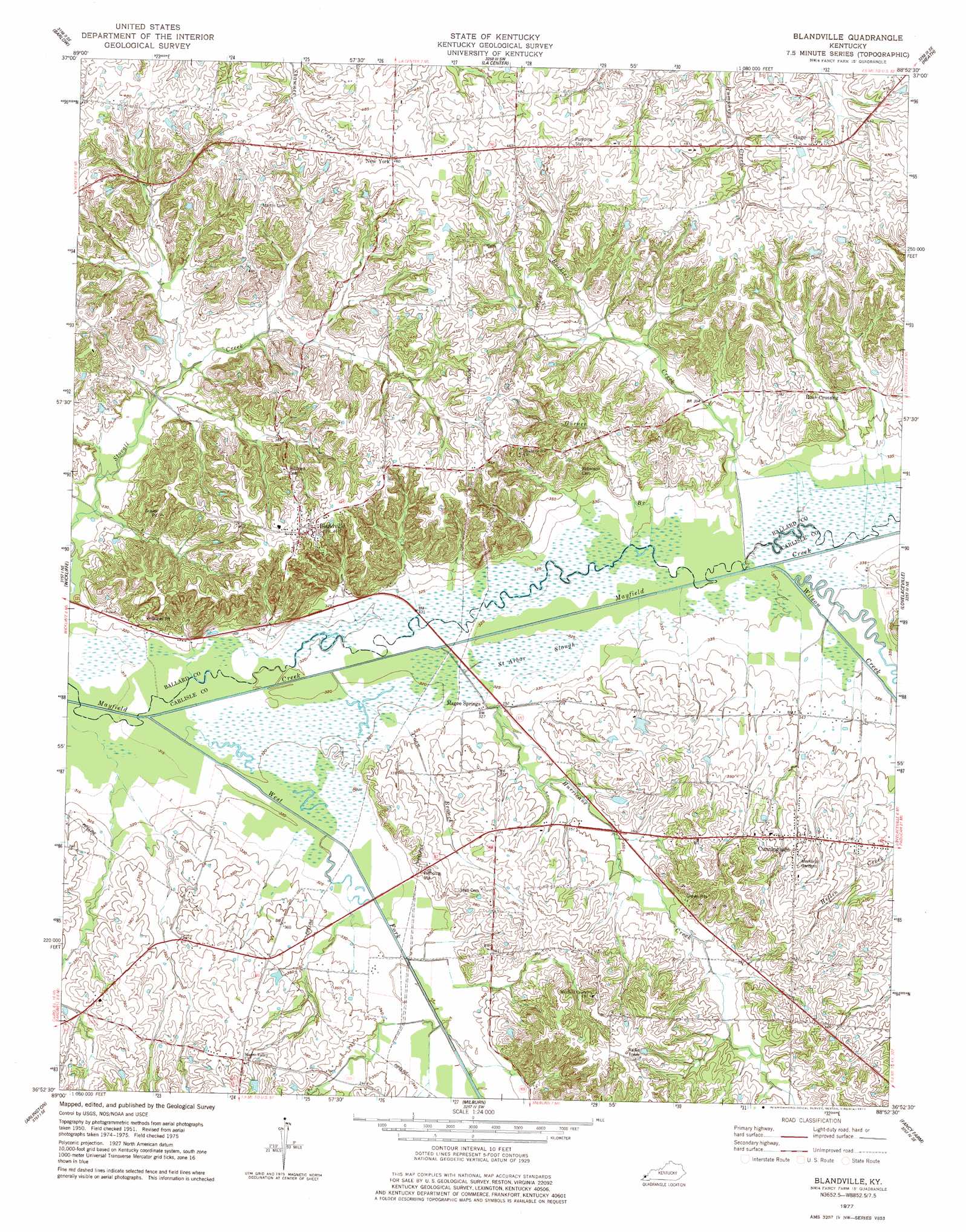
Blandville Topo Map Kentucky
To zoom in, hover over the map of Blandville
USGS Topo Quad 36088h8 - 1:24,000 scale
| Topo Map Name: | Blandville |
| USGS Topo Quad ID: | 36088h8 |
| Print Size: | ca. 21 1/4" wide x 27" high |
| Southeast Coordinates: | 36.875° N latitude / 88.875° W longitude |
| Map Center Coordinates: | 36.9375° N latitude / 88.9375° W longitude |
| U.S. State: | KY |
| Filename: | o36088h8.jpg |
| Download Map JPG Image: | Blandville topo map 1:24,000 scale |
| Map Type: | Topographic |
| Topo Series: | 7.5´ |
| Map Scale: | 1:24,000 |
| Source of Map Images: | United States Geological Survey (USGS) |
| Alternate Map Versions: |
Blandville KY 1951, updated 1952 Download PDF Buy paper map Blandville KY 1951, updated 1968 Download PDF Buy paper map Blandville KY 1977, updated 1977 Download PDF Buy paper map Blandville KY 2010 Download PDF Buy paper map Blandville KY 2013 Download PDF Buy paper map Blandville KY 2016 Download PDF Buy paper map |
1:24,000 Topo Quads surrounding Blandville
Pulaski |
Olmsted |
Bandana |
Joppa |
Metropolis |
Cairo |
Barlow |
La Center |
Heath |
Paducah West |
Wyatt |
Wickliffe |
Blandville |
Lovelaceville |
Melber |
Wickliffe Sw |
Arlington |
Milburn |
Fancy Farm |
Hickory |
Wolf Island |
Oakton |
Clinton |
Dublin |
Mayfield |
> Back to 36088e1 at 1:100,000 scale
> Back to 36088a1 at 1:250,000 scale
> Back to U.S. Topo Maps home
Blandville topo map: Gazetteer
Blandville: Populated Places
Blandville elevation 141m 462′Cunningham elevation 121m 396′
Gage elevation 145m 475′
Magee Springs elevation 98m 321′
New York elevation 140m 459′
Ross Crossing elevation 117m 383′
Blandville: Streams
Buckler Creek elevation 101m 331′Coon Branch elevation 97m 318′
Garner Branch elevation 99m 324′
Hurricane Creek elevation 98m 321′
West Fork Mayfield Creek elevation 94m 308′
Wilson Creek elevation 101m 331′
Blandville: Swamps
Saint Arbor Slough elevation 100m 328′Blandville digital topo map on disk
Buy this Blandville topo map showing relief, roads, GPS coordinates and other geographical features, as a high-resolution digital map file on DVD: