Abbott Lake Topo Map New Mexico
To zoom in, hover over the map of Abbott Lake
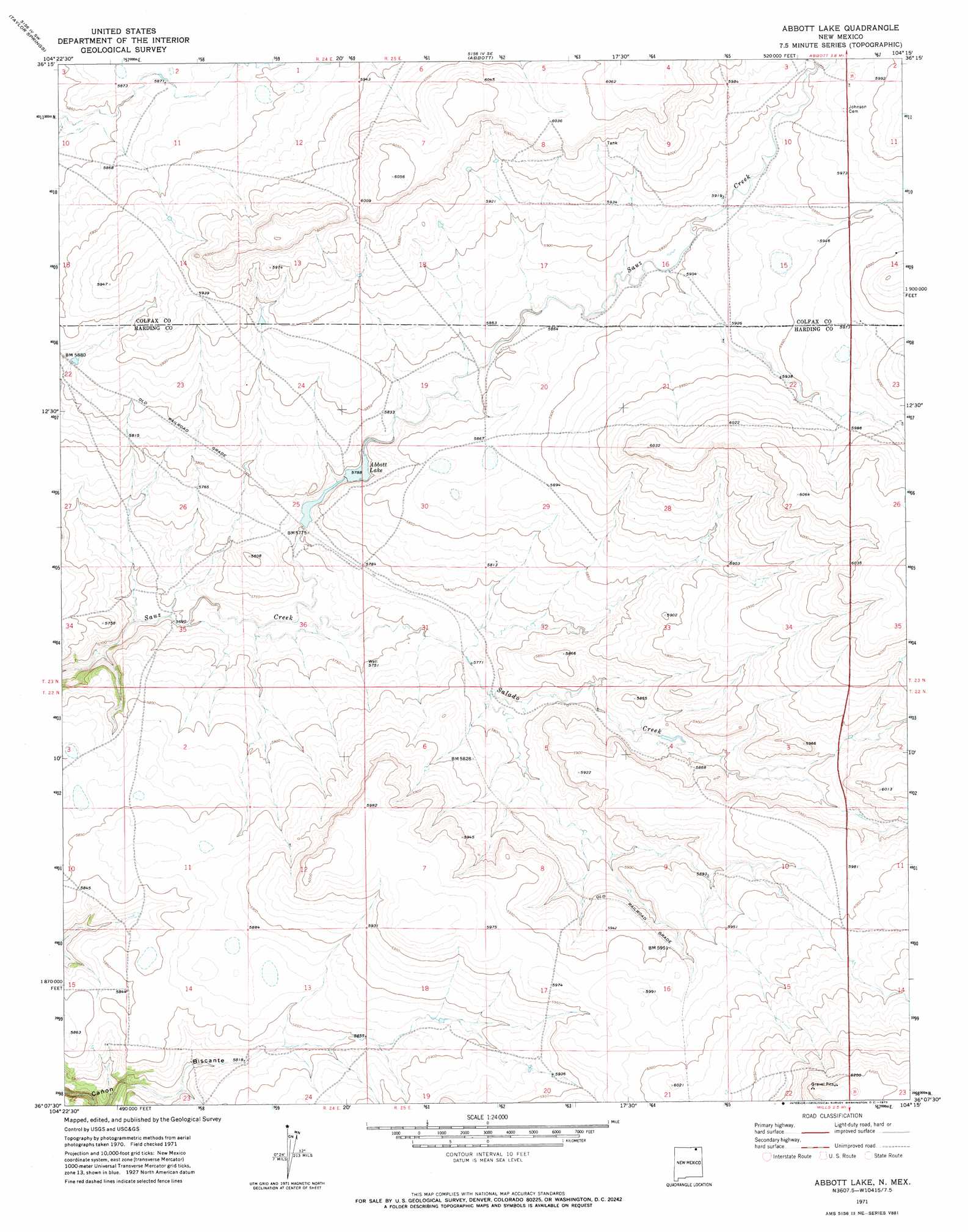
USGS Topo Quad 36104b3 - 1:24,000 scale
| Topo Map Name: | Abbott Lake |
| USGS Topo Quad ID: | 36104b3 |
| Print Size: | ca. 21 1/4" wide x 27" high |
| Southeast Coordinates: | 36.125° N latitude / 104.25° W longitude |
| Map Center Coordinates: | 36.1875° N latitude / 104.3125° W longitude |
| U.S. State: | NM |
| Filename: | o36104b3.jpg |
| Download Map JPG Image: | Abbott Lake topo map 1:24,000 scale |
| Map Type: | Topographic |
| Topo Series: | 7.5´ |
| Map Scale: | 1:24,000 |
| Source of Map Images: | United States Geological Survey (USGS) |
| Alternate Map Versions: |
Abbott Lake NM 1971, updated 1973 Download PDF Buy paper map Abbott Lake NM 1998, updated 2001 Download PDF Buy paper map Abbott Lake NM 2011 Download PDF Buy paper map Abbott Lake NM 2013 Download PDF Buy paper map |
| FStopo: | US Forest Service topo Abbott Lake is available: Download FStopo PDF Download FStopo TIF |
1:24,000 Topo Quads surrounding Abbott Lake
French |
Abbott Nw |
Sauble Circle Dot Ranch |
Point Of Rocks Mesa |
Lawrence Arroyo |
Springer |
Taylor Springs |
Abbott |
Ingram Lake |
Farley |
Stony Lake |
Jaritas Ranch |
Abbott Lake |
Spear Hills |
Divine Lake |
Alto De Hormiga |
Canon Colorado |
Mills West |
Mills East |
Kansas Valley |
Alamosa Creek |
Canon Las Cuevas |
Beaver Canyon |
Roy |
Kansas Valley Lake |
> Back to 36104a1 at 1:100,000 scale
> Back to 36104a1 at 1:250,000 scale
> Back to U.S. Topo Maps home
Abbott Lake topo map: Gazetteer
Abbott Lake: Dams
Abbott Lake Lower Dam elevation 1759m 5770′Abbott Lake Upper Dam elevation 1770m 5807′
Abbott Lake: Reservoirs
Abbott Lake elevation 1770m 5807′Abbott Lake: Springs
Ojo de Verde elevation 1813m 5948′Abbott Lake: Streams
Arroyo Ojo Verde elevation 1784m 5853′Salado Creek elevation 1741m 5711′
Abbott Lake: Valleys
Alex Draw elevation 1804m 5918′Abbott Lake digital topo map on disk
Buy this Abbott Lake topo map showing relief, roads, GPS coordinates and other geographical features, as a high-resolution digital map file on DVD: