Carson Topo Map New Mexico
To zoom in, hover over the map of Carson
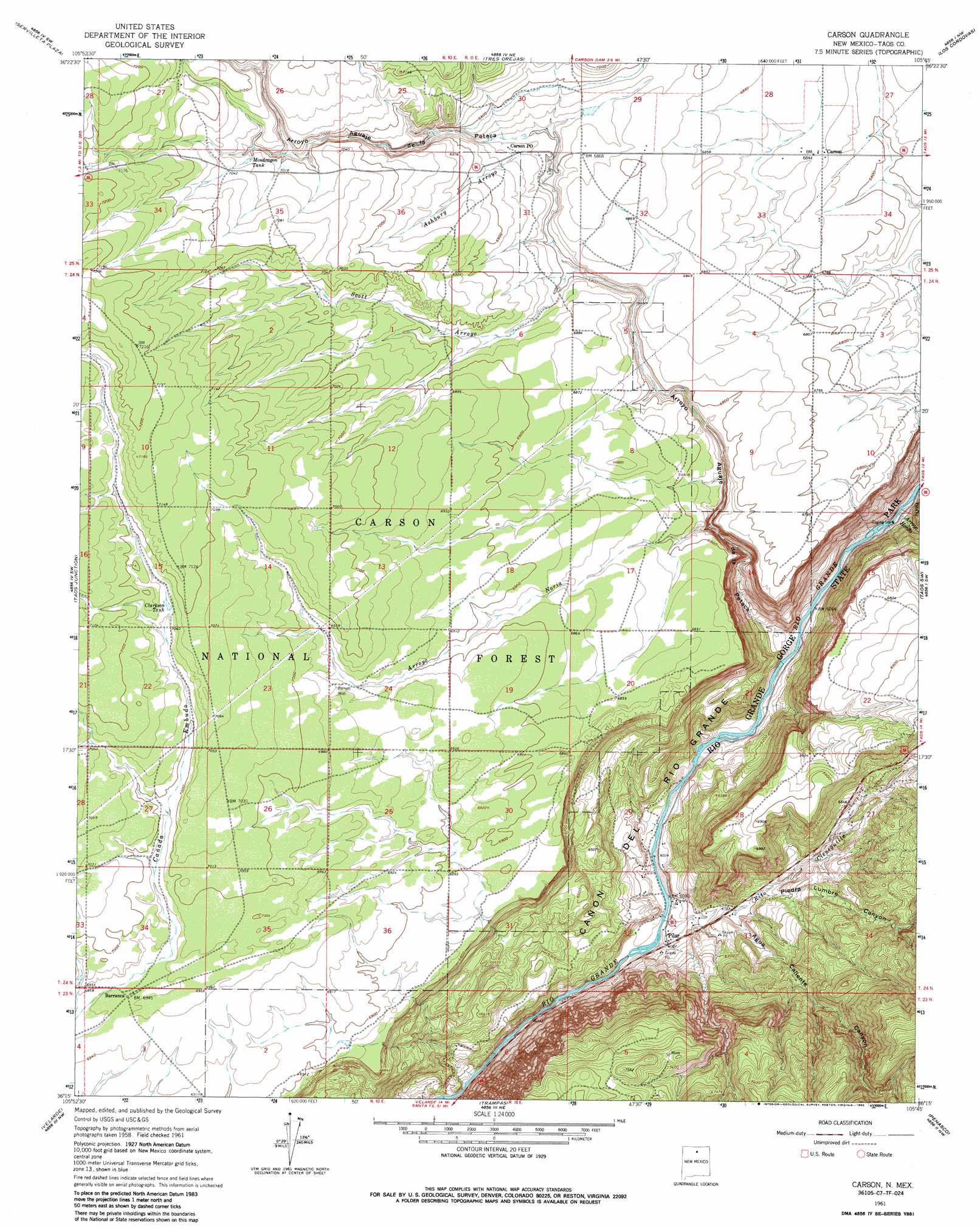
USGS Topo Quad 36105c7 - 1:24,000 scale
| Topo Map Name: | Carson |
| USGS Topo Quad ID: | 36105c7 |
| Print Size: | ca. 21 1/4" wide x 27" high |
| Southeast Coordinates: | 36.25° N latitude / 105.75° W longitude |
| Map Center Coordinates: | 36.3125° N latitude / 105.8125° W longitude |
| U.S. State: | NM |
| Filename: | o36105c7.jpg |
| Download Map JPG Image: | Carson topo map 1:24,000 scale |
| Map Type: | Topographic |
| Topo Series: | 7.5´ |
| Map Scale: | 1:24,000 |
| Source of Map Images: | United States Geological Survey (USGS) |
| Alternate Map Versions: |
Carson NM 1961, updated 1963 Download PDF Buy paper map Carson NM 1961, updated 1973 Download PDF Buy paper map Carson NM 1961, updated 1985 Download PDF Buy paper map Carson NM 1995, updated 1998 Download PDF Buy paper map Carson NM 2011 Download PDF Buy paper map Carson NM 2013 Download PDF Buy paper map |
| FStopo: | US Forest Service topo Carson is available: Download FStopo PDF Download FStopo TIF |
1:24,000 Topo Quads surrounding Carson
Las Tablas |
Petaca Peak |
Cerro De Los Taoses |
Arroyo Hondo |
Arroyo Seco |
La Madera |
Servilleta Plaza |
Tres Orejas |
Los Cordovas |
Taos |
Ojo Caliente |
Taos Junction |
Carson |
Taos Sw |
Ranchos De Taos |
Lyden |
Velarde |
Trampas |
Penasco |
Tres Ritos |
San Juan Pueblo |
Chimayo |
Truchas |
El Valle |
Jicarita Peak |
> Back to 36105a1 at 1:100,000 scale
> Back to 36104a1 at 1:250,000 scale
> Back to U.S. Topo Maps home
Carson topo map: Gazetteer
Carson: Arroyos
Arroyo Noria elevation 2005m 6578′Carson: Mines
Bismuth Prospect elevation 1979m 6492′Blue Feather Claims elevation 2076m 6811′
Pillar Prospects elevation 1919m 6295′
Carson: Parks
Pilar Historical Marker elevation 1847m 6059′Pueblo Revolt Tricentennial Historical Marker elevation 1847m 6059′
Rio Grande Gorge State Park elevation 1844m 6049′
Vasquez de Coronados Route Historical Marker elevation 1847m 6059′
Carson: Populated Places
Barranca elevation 2119m 6952′Carson elevation 2087m 6847′
Pilar elevation 1847m 6059′
Carson: Post Offices
Carson Post Office (historical) elevation 2087m 6847′Pilar Post Office (historical) elevation 1847m 6059′
Carson: Rapids
Alberts Falls Rapid elevation 1824m 5984′Gaging Station Rapid elevation 1847m 6059′
The Karmic Wave Rapid elevation 1830m 6003′
The Narrows Rapid elevation 1932m 6338′
Carson: Reservoirs
Clarkson Tank elevation 2150m 7053′Hartig Tank elevation 2141m 7024′
Mondragon Tank elevation 2143m 7030′
Montosa Tank elevation 2165m 7103′
Sandy Tank elevation 2148m 7047′
Section Thirty-five Tank elevation 2145m 7037′
Carson: Streams
Arroyo Aguaje de la Petaca elevation 1844m 6049′Arroyo Hondo elevation 1848m 6062′
Arroyo Noria elevation 2005m 6578′
Ashbury Arroyo elevation 2073m 6801′
Rito Cieneguilla elevation 1836m 6023′
Scott Arroyo elevation 2066m 6778′
Carson: Valleys
Agua Caliente Canyon elevation 1886m 6187′Hondo Canyon elevation 1862m 6108′
Piedra Lumbre Canyon elevation 1903m 6243′
Tierra Amarilla Canyon elevation 1922m 6305′
Carson: Wells
10046 Water Well elevation 2095m 6873′Barnett Well elevation 2123m 6965′
Carson digital topo map on disk
Buy this Carson topo map showing relief, roads, GPS coordinates and other geographical features, as a high-resolution digital map file on DVD: