Tres Ritos Topo Map New Mexico
To zoom in, hover over the map of Tres Ritos
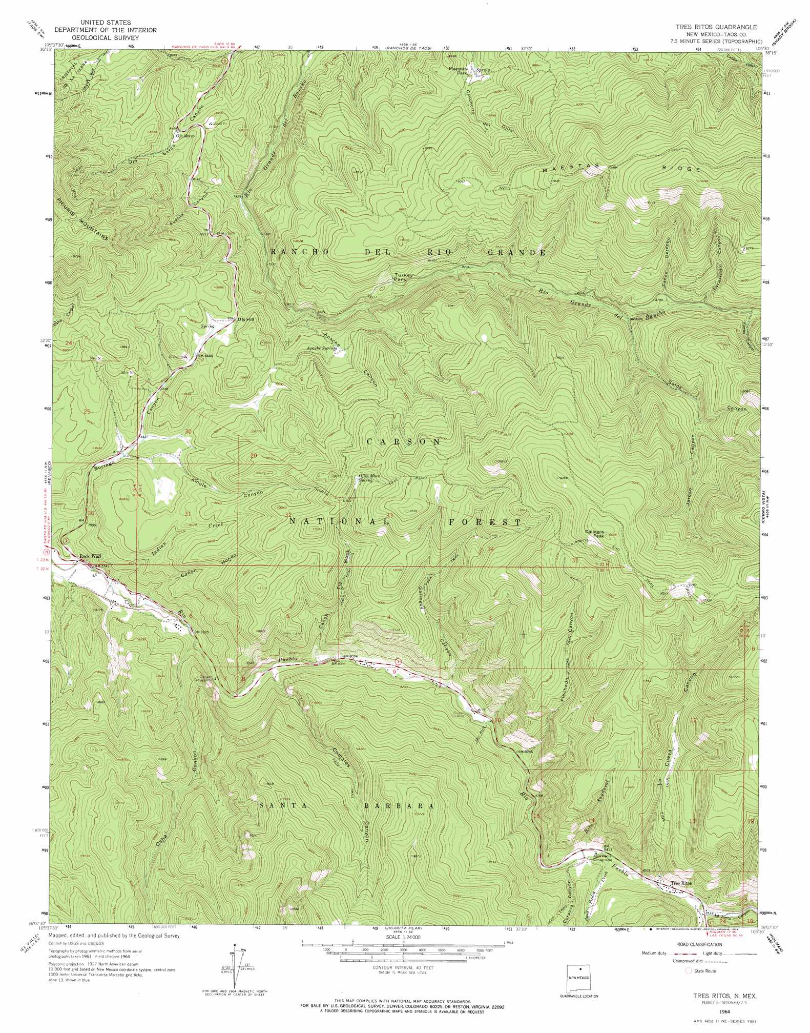
USGS Topo Quad 36105b5 - 1:24,000 scale
| Topo Map Name: | Tres Ritos |
| USGS Topo Quad ID: | 36105b5 |
| Print Size: | ca. 21 1/4" wide x 27" high |
| Southeast Coordinates: | 36.125° N latitude / 105.5° W longitude |
| Map Center Coordinates: | 36.1875° N latitude / 105.5625° W longitude |
| U.S. State: | NM |
| Filename: | o36105b5.jpg |
| Download Map JPG Image: | Tres Ritos topo map 1:24,000 scale |
| Map Type: | Topographic |
| Topo Series: | 7.5´ |
| Map Scale: | 1:24,000 |
| Source of Map Images: | United States Geological Survey (USGS) |
| Alternate Map Versions: |
Tres Ritos NM 1964, updated 1967 Download PDF Buy paper map Tres Ritos NM 1964, updated 1974 Download PDF Buy paper map Tres Ritos NM 1995, updated 1997 Download PDF Buy paper map Tres Ritos NM 2011 Download PDF Buy paper map Tres Ritos NM 2013 Download PDF Buy paper map |
| FStopo: | US Forest Service topo Tres Ritos is available: Download FStopo PDF Download FStopo TIF |
1:24,000 Topo Quads surrounding Tres Ritos
Tres Orejas |
Los Cordovas |
Taos |
Pueblo Peak |
Palo Flechado Pass |
Carson |
Taos Sw |
Ranchos De Taos |
Shady Brook |
Osha Mountain |
Trampas |
Penasco |
Tres Ritos |
Cerro Vista |
Chacon |
Truchas |
El Valle |
Jicarita Peak |
Holman |
Comanche Peak |
Sierra Mosca |
Truchas Peak |
Pecos Falls |
Gascon |
Mora |
> Back to 36105a1 at 1:100,000 scale
> Back to 36104a1 at 1:250,000 scale
> Back to U.S. Topo Maps home
Tres Ritos topo map: Gazetteer
Tres Ritos: Areas
Llanito Frio elevation 2478m 8129′Tres Ritos: Benches
Cuchillas Peladas elevation 2851m 9353′Tres Ritos: Flats
Gallegos Park elevation 3143m 10311′Maestas Park elevation 2547m 8356′
Turkey Park elevation 2634m 8641′
Tres Ritos: Mines
Limestone Quarry elevation 2624m 8608′Taos Mill elevation 2703m 8868′
Tojo Mine elevation 2648m 8687′
US Hill Mine elevation 2648m 8687′
Tres Ritos: Populated Places
Las Mochas elevation 2458m 8064′Rock Wall elevation 2355m 7726′
Sipapu elevation 2496m 8188′
Tres Ritos elevation 2582m 8471′
Tres Ritos: Post Offices
Tres Ritos Post Office (historical) elevation 2582m 8471′Tres Ritos: Reservoirs
Flechado Trick Tank elevation 3039m 9970′Fuente Trick Tank elevation 2636m 8648′
Rojo Tank elevation 2505m 8218′
Tres Ritos: Ridges
Maestas Ridge elevation 3012m 9881′Tres Ritos: Springs
Apache Springs elevation 2594m 8510′Maestas Spring elevation 2547m 8356′
Ojito Maes Spring elevation 2814m 9232′
Tres Ritos: Streams
Agua Piedra Creek elevation 2563m 8408′Indian Creek elevation 2357m 7732′
Rito la Presa elevation 2591m 8500′
Rito Sandoval elevation 2572m 8438′
Tres Ritos: Summits
Gallegos Peak elevation 3211m 10534′U S Hill elevation 2609m 8559′
Tres Ritos: Trails
Comales Sheep Driveway elevation 2615m 8579′North End Trail elevation 2804m 9199′
Tres Ritos: Valleys
Amole Canyon elevation 2494m 8182′Apache Canyon elevation 2458m 8064′
Cañon Derecho elevation 2649m 8690′
Cañon Hondo elevation 2375m 7791′
Cañon Tio Maes elevation 2443m 8015′
Comales Canyon elevation 2420m 7939′
Cordova Canyon elevation 2549m 8362′
Escarrodio Canyon elevation 2668m 8753′
Flechado Canyon elevation 2513m 8244′
Fowler Canyon elevation 2701m 8861′
Fuente Canyon elevation 2383m 7818′
Gallegos Canyon elevation 2491m 8172′
Jaroso Canyon elevation 2749m 9019′
La Cueva Canyon elevation 2572m 8438′
La Junta Canyon elevation 2597m 8520′
Osha Canyon elevation 2387m 7831′
Saloz Canyon elevation 2615m 8579′
Tres Ritos digital topo map on disk
Buy this Tres Ritos topo map showing relief, roads, GPS coordinates and other geographical features, as a high-resolution digital map file on DVD: