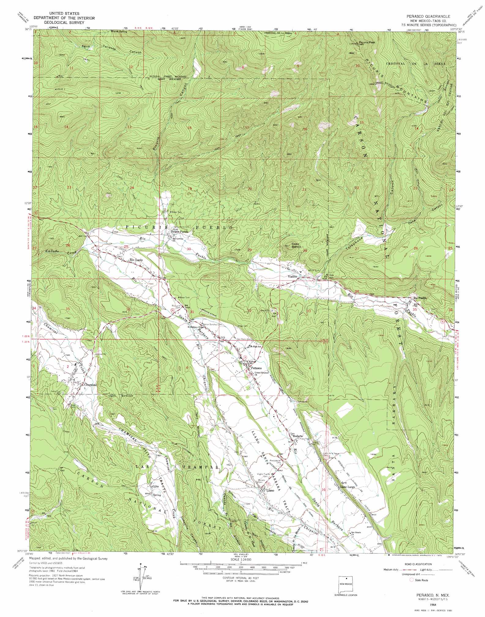
Penasco Topo Map New Mexico
To zoom in, hover over the map of Penasco
USGS Topo Quad 36105b6 - 1:24,000 scale
| Topo Map Name: | Penasco |
| USGS Topo Quad ID: | 36105b6 |
| Print Size: | ca. 21 1/4" wide x 27" high |
| Southeast Coordinates: | 36.125° N latitude / 105.625° W longitude |
| Map Center Coordinates: | 36.1875° N latitude / 105.6875° W longitude |
| U.S. State: | NM |
| Filename: | o36105b6.jpg |
| Download Map JPG Image: | Penasco topo map 1:24,000 scale |
| Map Type: | Topographic |
| Topo Series: | 7.5´ |
| Map Scale: | 1:24,000 |
| Source of Map Images: | United States Geological Survey (USGS) |
| Alternate Map Versions: |
Penasco NM 1964, updated 1967 Download PDF Buy paper map Penasco NM 1964, updated 1973 Download PDF Buy paper map Penasco NM 1995, updated 1997 Download PDF Buy paper map Penasco NM 2011 Download PDF Buy paper map Penasco NM 2013 Download PDF Buy paper map |
| FStopo: | US Forest Service topo Penasco is available: Download FStopo PDF Download FStopo TIF |
1:24,000 Topo Quads surrounding Penasco
Servilleta Plaza |
Tres Orejas |
Los Cordovas |
Taos |
Pueblo Peak |
Taos Junction |
Carson |
Taos Sw |
Ranchos De Taos |
Shady Brook |
Velarde |
Trampas |
Penasco |
Tres Ritos |
Cerro Vista |
Chimayo |
Truchas |
El Valle |
Jicarita Peak |
Holman |
Cundiyo |
Sierra Mosca |
Truchas Peak |
Pecos Falls |
Gascon |
> Back to 36105a1 at 1:100,000 scale
> Back to 36104a1 at 1:250,000 scale
> Back to U.S. Topo Maps home
Penasco topo map: Gazetteer
Penasco: Canals
Acequia del Llano de la Yegua elevation 2522m 8274′Acequia Madre de Llano San Juan elevation 2477m 8126′
Acequia Madre de Santa Barbara elevation 2395m 7857′
Acequia Monte elevation 2499m 8198′
Chamizal Ditch elevation 2530m 8300′
Penasco: Mines
Green Mountain Group elevation 2532m 8307′Penasco: Parks
Pueblo of Picuris Historical Marker elevation 2232m 7322′Penasco: Populated Places
Chamisal elevation 2278m 7473′Llano elevation 2455m 8054′
Llano Largo elevation 2464m 8083′
Ojito elevation 2443m 8015′
Peñasco elevation 2343m 7687′
Picuris Pueblo elevation 2232m 7322′
Rio Lucio elevation 2210m 7250′
Rio Pueblo elevation 2328m 7637′
Rodarte elevation 2411m 7910′
Vadito elevation 2271m 7450′
Penasco: Post Offices
Chamisal Post Office elevation 2278m 7473′Llano Post Office (historical) elevation 2455m 8054′
Peñasco Post Office elevation 2343m 7687′
Rio Lucio Post Office (historical) elevation 2210m 7250′
Rio Pueblo Post Office (historical) elevation 2328m 7637′
Rodarte Post Office (historical) elevation 2411m 7910′
Vadito Post Office elevation 2271m 7450′
Penasco: Ridges
Picuris Mountains elevation 2967m 9734′Penasco: Streams
Cañada de la Plaza elevation 2498m 8195′Cañada los Alamos elevation 2409m 7903′
Cañada los Moras elevation 2499m 8198′
Rio Chiquito elevation 2285m 7496′
Rio Pueblo elevation 2183m 7162′
Rio Santa Barbara elevation 2183m 7162′
Penasco: Summits
Cerro Blanco elevation 2420m 7939′Picuris Peak elevation 3292m 10800′
Penasco: Valleys
Borrego Canyon elevation 2350m 7709′Cañada de las Moras elevation 2499m 8198′
Cebadilla Canyon elevation 2444m 8018′
Osha Canyon elevation 2435m 7988′
Picuris Canyon elevation 2233m 7326′
Telephone Canyon elevation 2292m 7519′
Penasco: Wells
10043 Water Well elevation 2352m 7716′10044 Water Well elevation 2221m 7286′
Number 1 Water Well elevation 2373m 7785′
RG 32550 Water Well elevation 2291m 7516′
RG-26430 Water Well elevation 2405m 7890′
RG-26474 Water Well elevation 2478m 8129′
Penasco digital topo map on disk
Buy this Penasco topo map showing relief, roads, GPS coordinates and other geographical features, as a high-resolution digital map file on DVD: