Findlay Tank Topo Map Arizona
To zoom in, hover over the map of Findlay Tank
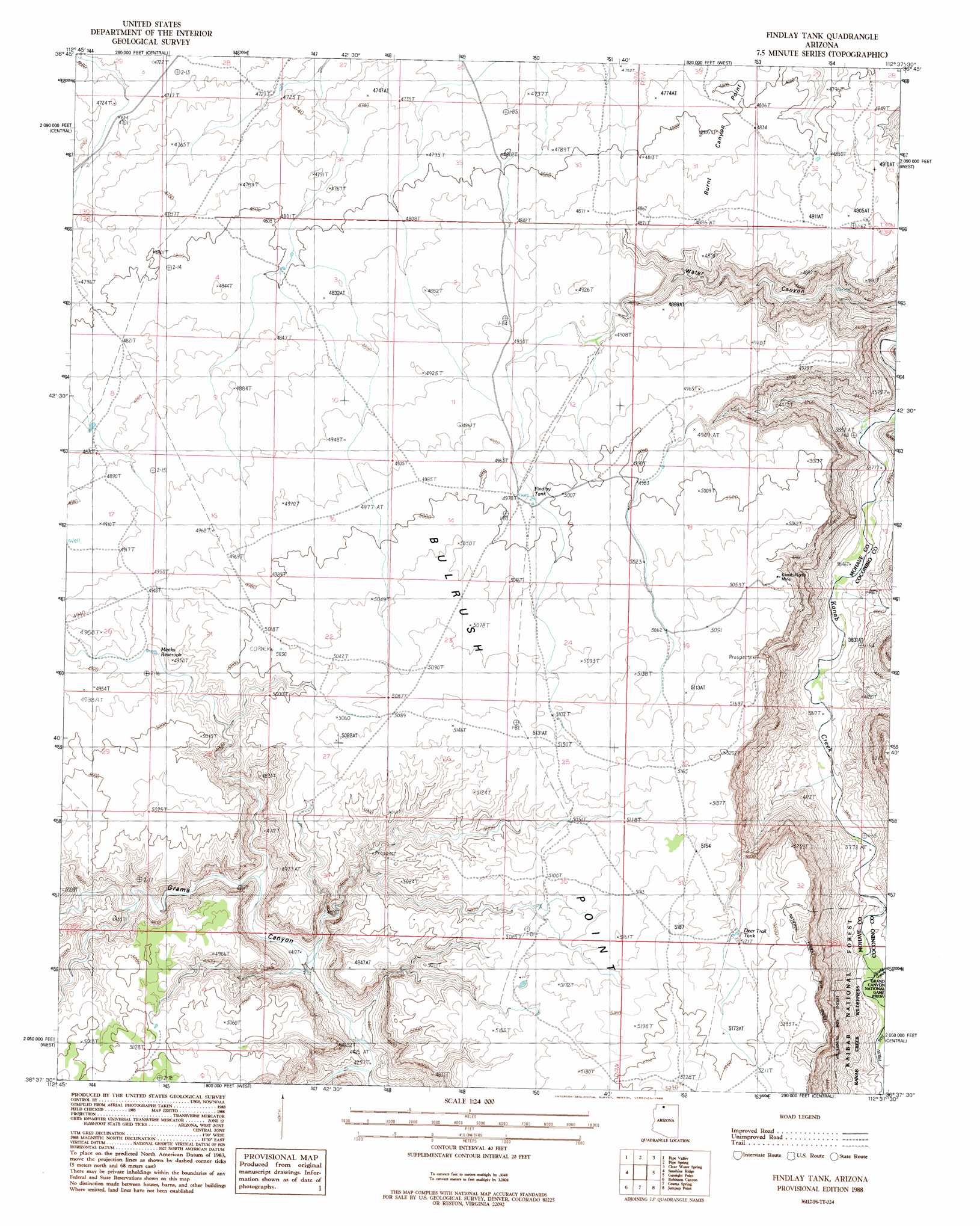
USGS Topo Quad 36112f6 - 1:24,000 scale
| Topo Map Name: | Findlay Tank |
| USGS Topo Quad ID: | 36112f6 |
| Print Size: | ca. 21 1/4" wide x 27" high |
| Southeast Coordinates: | 36.625° N latitude / 112.625° W longitude |
| Map Center Coordinates: | 36.6875° N latitude / 112.6875° W longitude |
| U.S. State: | AZ |
| Filename: | o36112f6.jpg |
| Download Map JPG Image: | Findlay Tank topo map 1:24,000 scale |
| Map Type: | Topographic |
| Topo Series: | 7.5´ |
| Map Scale: | 1:24,000 |
| Source of Map Images: | United States Geological Survey (USGS) |
| Alternate Map Versions: |
Findlay Tank AZ 1988, updated 1988 Download PDF Buy paper map Findlay Tank AZ 2012 Download PDF Buy paper map Findlay Tank AZ 2014 Download PDF Buy paper map |
| FStopo: | US Forest Service topo Findlay Tank is available: Download FStopo PDF Download FStopo TIF |
1:24,000 Topo Quads surrounding Findlay Tank
Colorado City |
Moccasin |
Kaibab |
Fredonia |
Shinarump Point |
Maroney Well |
Pipe Valley |
Pipe Spring |
Clear Water Spring |
White Sage Flat |
Wild Band Pockets |
Sunshine Ridge |
Findlay Tank |
Gunsight Point |
Toothpick Ridge |
Heaton Knolls |
Robinson Canyon |
Grama Spring |
Jumpup Point |
Sowats Spring |
Hancock Knolls |
Hitson Tank |
Kanab Point |
Fishtail Mesa |
Tapeats Amphitheater |
> Back to 36112e1 at 1:100,000 scale
> Back to 36112a1 at 1:250,000 scale
> Back to U.S. Topo Maps home
Findlay Tank topo map: Gazetteer
Findlay Tank: Cliffs
Burnt Canyon Point elevation 1489m 4885′Findlay Tank: Mines
Kanab-North Mine elevation 1525m 5003′Findlay Tank: Reservoirs
Deer Trail Tank elevation 1560m 5118′Findlay Tank elevation 1519m 4983′
Meeks Reservoir elevation 1488m 4881′
Findlay Tank: Valleys
Water Canyon elevation 1233m 4045′Findlay Tank digital topo map on disk
Buy this Findlay Tank topo map showing relief, roads, GPS coordinates and other geographical features, as a high-resolution digital map file on DVD: