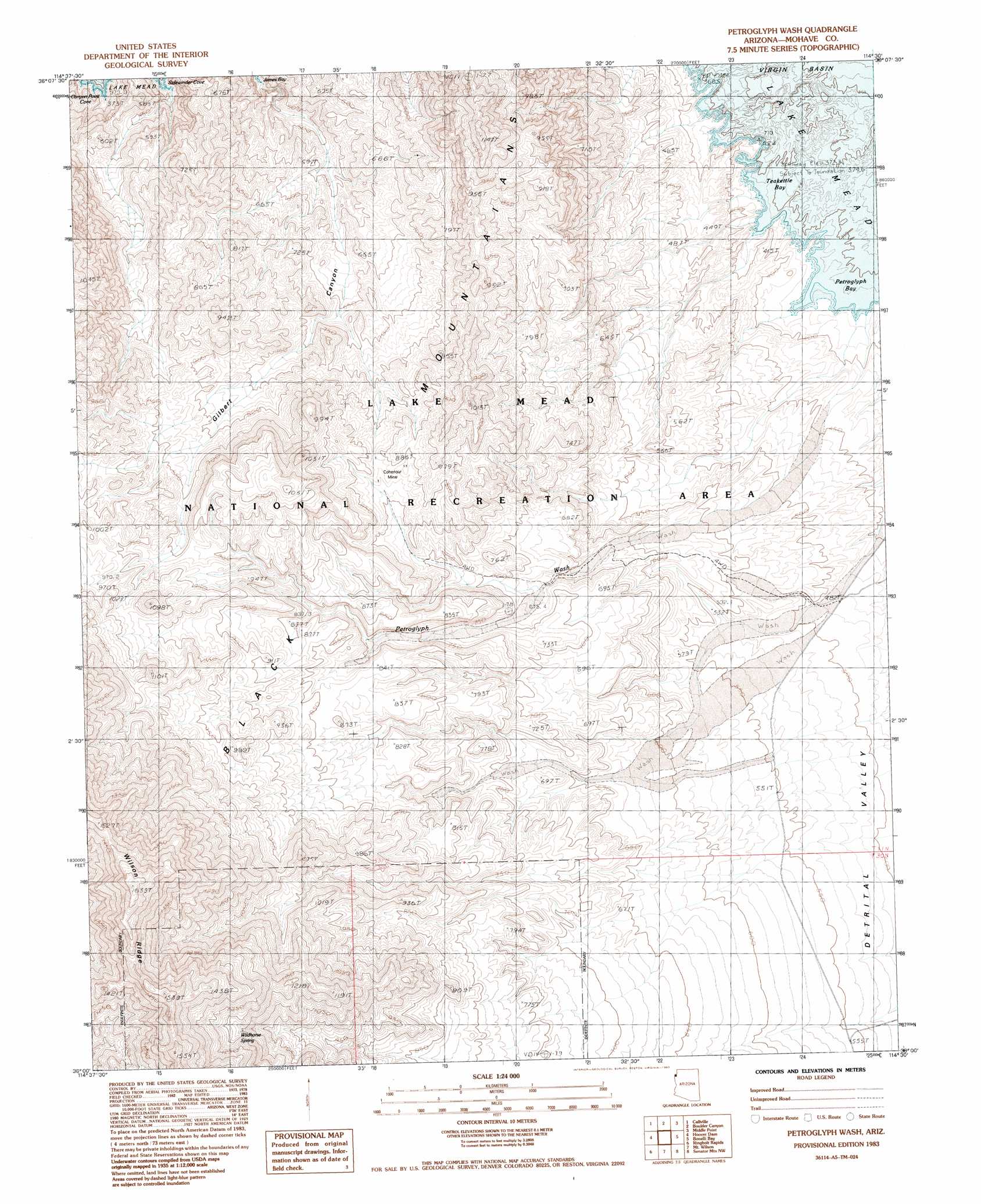
Petroglyph Wash Topo Map Arizona
To zoom in, hover over the map of Petroglyph Wash
USGS Topo Quad 36114a5 - 1:24,000 scale
| Topo Map Name: | Petroglyph Wash |
| USGS Topo Quad ID: | 36114a5 |
| Print Size: | ca. 21 1/4" wide x 27" high |
| Southeast Coordinates: | 36° N latitude / 114.5° W longitude |
| Map Center Coordinates: | 36.0625° N latitude / 114.5625° W longitude |
| U.S. State: | AZ |
| Filename: | o36114a5.jpg |
| Download Map JPG Image: | Petroglyph Wash topo map 1:24,000 scale |
| Map Type: | Topographic |
| Topo Series: | 7.5´ |
| Map Scale: | 1:24,000 |
| Source of Map Images: | United States Geological Survey (USGS) |
| Alternate Map Versions: |
Petroglyph Wash AZ 1983, updated 1983 Download PDF Buy paper map Petroglyph Wash AZ 2011 Download PDF Buy paper map Petroglyph Wash AZ 2014 Download PDF Buy paper map |
1:24,000 Topo Quads surrounding Petroglyph Wash
Dry Lake Se |
Muddy Peak |
Bitter Spring |
Echo Bay |
Lime Wash |
Government Wash |
Callville Bay |
Boulder Canyon |
Middle Point |
Garrett Butte |
Boulder Beach |
Hoover Dam |
Petroglyph Wash |
Bonelli Bay |
The Temple |
Boulder City |
Ringbolt Rapids |
Mount Wilson |
Senator Mountain Nw |
Senator Mountain Ne |
Boulder City Se |
Willow Beach |
Housholder Pass |
Senator Mountain Sw |
Senator Mountain |
> Back to 36114a1 at 1:100,000 scale
> Back to 36114a1 at 1:250,000 scale
> Back to U.S. Topo Maps home
Petroglyph Wash topo map: Gazetteer
Petroglyph Wash: Bays
Petroglyph Bay elevation 367m 1204′Teakettle Bay elevation 367m 1204′
Petroglyph Wash: Mines
Cohenour Mine elevation 841m 2759′Petroglyph Wash: Springs
Wildhorse Spring elevation 1177m 3861′Petroglyph Wash: Valleys
Gilbert Canyon elevation 447m 1466′Petroglyph Wash elevation 367m 1204′
Petroglyph Wash digital topo map on disk
Buy this Petroglyph Wash topo map showing relief, roads, GPS coordinates and other geographical features, as a high-resolution digital map file on DVD:
Southern Sierra Nevada, California & Southern Nevada
Buy digital topo maps: Southern Sierra Nevada, California & Southern Nevada