Boulder Canyon Topo Map Nevada
To zoom in, hover over the map of Boulder Canyon
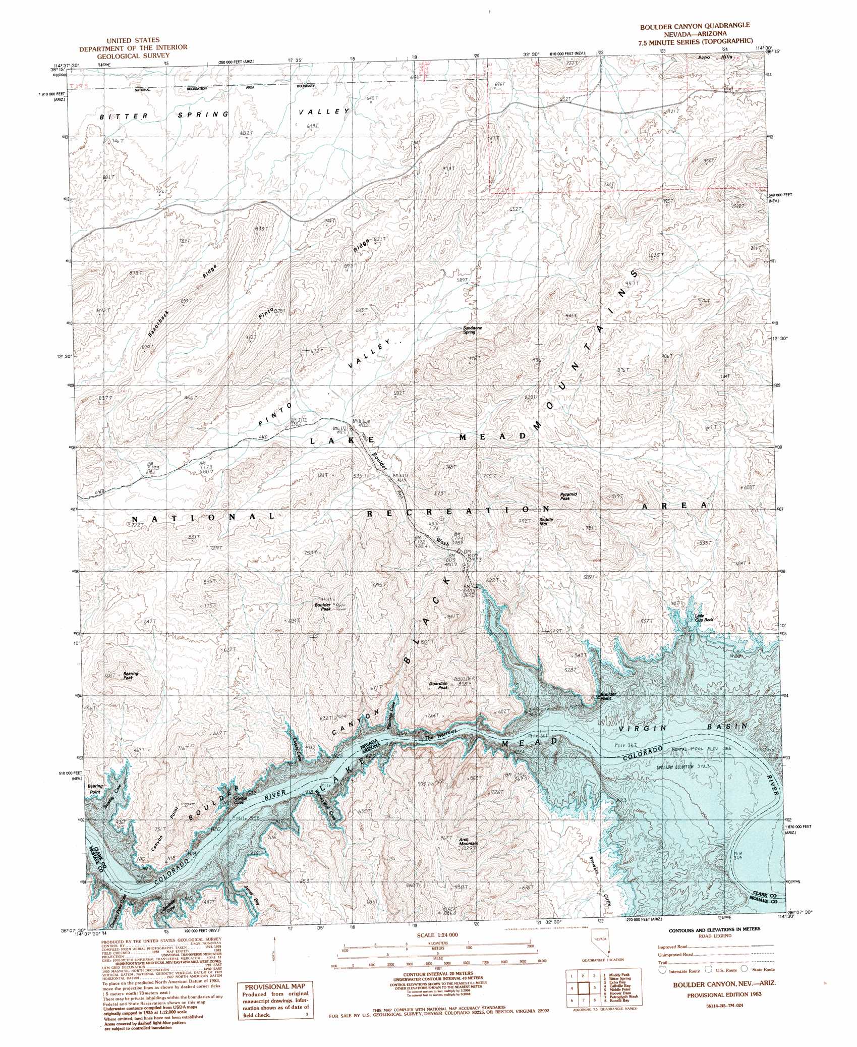
USGS Topo Quad 36114b5 - 1:24,000 scale
| Topo Map Name: | Boulder Canyon |
| USGS Topo Quad ID: | 36114b5 |
| Print Size: | ca. 21 1/4" wide x 27" high |
| Southeast Coordinates: | 36.125° N latitude / 114.5° W longitude |
| Map Center Coordinates: | 36.1875° N latitude / 114.5625° W longitude |
| U.S. States: | NV, AZ |
| Filename: | o36114b5.jpg |
| Download Map JPG Image: | Boulder Canyon topo map 1:24,000 scale |
| Map Type: | Topographic |
| Topo Series: | 7.5´ |
| Map Scale: | 1:24,000 |
| Source of Map Images: | United States Geological Survey (USGS) |
| Alternate Map Versions: |
Boulder Canyon NV 1983, updated 1984 Download PDF Buy paper map Boulder Canyon NV 2012 Download PDF Buy paper map Boulder Canyon NV 2014 Download PDF Buy paper map |
1:24,000 Topo Quads surrounding Boulder Canyon
Dry Lake |
Piute Point |
Valley Of Fire West |
Valley Of Fire East |
Overton Beach |
Dry Lake Se |
Muddy Peak |
Bitter Spring |
Echo Bay |
Lime Wash |
Government Wash |
Callville Bay |
Boulder Canyon |
Middle Point |
Garrett Butte |
Boulder Beach |
Hoover Dam |
Petroglyph Wash |
Bonelli Bay |
The Temple |
Boulder City |
Ringbolt Rapids |
Mount Wilson |
Senator Mountain Nw |
Senator Mountain Ne |
> Back to 36114a1 at 1:100,000 scale
> Back to 36114a1 at 1:250,000 scale
> Back to U.S. Topo Maps home
Boulder Canyon topo map: Gazetteer
Boulder Canyon: Bars
Gypsum Beds elevation 367m 1204′Little Gyp Beds elevation 367m 1204′
Boulder Canyon: Basins
Bitter Spring Valley elevation 660m 2165′Pinto Valley elevation 536m 1758′
Boulder Canyon: Bays
Bearing Cove elevation 367m 1204′Boulder Wash Cove elevation 367m 1204′
Canyon Point Cove elevation 367m 1204′
Coyote Cove elevation 367m 1204′
Flamingo Cove elevation 367m 1204′
Gordys Cove elevation 367m 1204′
James Bay elevation 367m 1204′
Sidewinder Cove elevation 367m 1204′
Wishing Well Cove elevation 367m 1204′
Boulder Canyon: Capes
Bearing Point elevation 404m 1325′Boulder Point elevation 481m 1578′
Boulder Canyon: Channels
The Narrows elevation 367m 1204′Boulder Canyon: Cliffs
Stewart Cliffs elevation 398m 1305′Boulder Canyon: Rapids
Boulder Rapids (historical) elevation 367m 1204′Boulder Canyon: Ridges
Canyon Point elevation 725m 2378′Pinto Ridge elevation 816m 2677′
Razorback Ridge elevation 756m 2480′
Boulder Canyon: Springs
Sandstone Spring elevation 586m 1922′Boulder Canyon: Streams
Boulder Wash elevation 383m 1256′Boulder Canyon: Summits
Arch Mountain elevation 1001m 3284′Bearing Peak elevation 660m 2165′
Boulder Peak elevation 841m 2759′
Guardian Peak elevation 813m 2667′
Pyramid Peak elevation 886m 2906′
Saddle Mountain elevation 703m 2306′
Boulder Canyon: Valleys
Boulder Canyon elevation 367m 1204′Boulder Canyon elevation 367m 1204′
Boulder Canyon digital topo map on disk
Buy this Boulder Canyon topo map showing relief, roads, GPS coordinates and other geographical features, as a high-resolution digital map file on DVD:
Southern Sierra Nevada, California & Southern Nevada
Buy digital topo maps: Southern Sierra Nevada, California & Southern Nevada