Springville Topo Map California
To zoom in, hover over the map of Springville
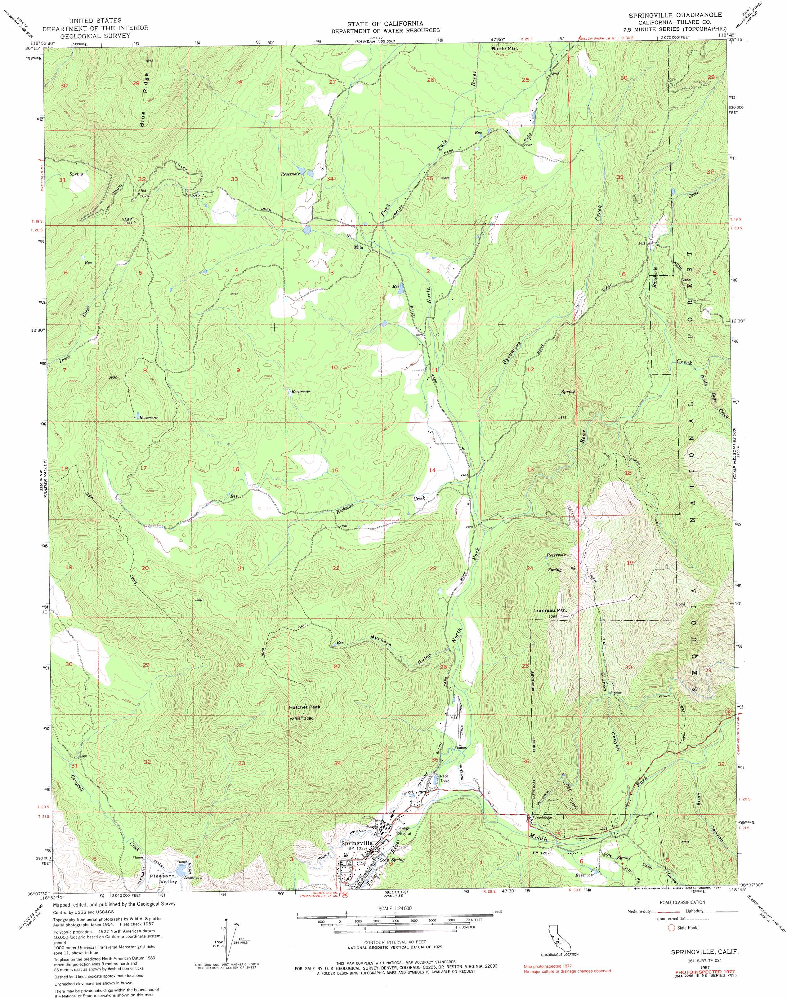
USGS Topo Quad 36118b7 - 1:24,000 scale
| Topo Map Name: | Springville |
| USGS Topo Quad ID: | 36118b7 |
| Print Size: | ca. 21 1/4" wide x 27" high |
| Southeast Coordinates: | 36.125° N latitude / 118.75° W longitude |
| Map Center Coordinates: | 36.1875° N latitude / 118.8125° W longitude |
| U.S. State: | CA |
| Filename: | o36118b7.jpg |
| Download Map JPG Image: | Springville topo map 1:24,000 scale |
| Map Type: | Topographic |
| Topo Series: | 7.5´ |
| Map Scale: | 1:24,000 |
| Source of Map Images: | United States Geological Survey (USGS) |
| Alternate Map Versions: |
Springville CA 1957, updated 1958 Download PDF Buy paper map Springville CA 1957, updated 1970 Download PDF Buy paper map Springville CA 1977, updated 1987 Download PDF Buy paper map Springville CA 2012 Download PDF Buy paper map Springville CA 2015 Download PDF Buy paper map |
| FStopo: | US Forest Service topo Springville is available: Download FStopo PDF Download FStopo TIF |
1:24,000 Topo Quads surrounding Springville
Woodlake |
Kaweah |
Case Mountain |
Silver City |
Mineral King |
Rocky Hill |
Chickencoop Canyon |
Dennison Peak |
Moses Mountain |
Quinn Peak |
Lindsay |
Frazier Valley |
Springville |
Camp Wishon |
Camp Nelson |
Porterville |
Success Dam |
Globe |
Solo Peak |
Sentinel Peak |
Ducor |
Fountain Springs |
Gibbon Peak |
California Hot Springs |
Johnsondale |
> Back to 36118a1 at 1:100,000 scale
> Back to 36118a1 at 1:250,000 scale
> Back to U.S. Topo Maps home
Springville topo map: Gazetteer
Springville: Airports
Sequoia Ranch Airport elevation 357m 1171′Springville: Canals
Mount Whitney Ditch elevation 333m 1092′Springville: Populated Places
Milo elevation 551m 1807′Springville elevation 312m 1023′
Springville: Post Offices
Springville Post Office elevation 308m 1010′Springville: Springs
Soda Spring elevation 300m 984′Springville: Streams
Bear Creek elevation 401m 1315′Hickman Creek elevation 427m 1400′
Middle Fork Tule River elevation 316m 1036′
North Fork Tule River elevation 316m 1036′
Rancheria Creek elevation 629m 2063′
South Bear Creek elevation 649m 2129′
Sycamore Creek elevation 422m 1384′
Springville: Summits
Hatchet Peak elevation 994m 3261′Lumreau Mountain elevation 937m 3074′
Springville: Valleys
Buckeye Gulch elevation 370m 1213′Deep Canyon elevation 392m 1286′
Long Canyon elevation 467m 1532′
Siphon Canyon elevation 425m 1394′
Ward Canyon elevation 367m 1204′
Springville digital topo map on disk
Buy this Springville topo map showing relief, roads, GPS coordinates and other geographical features, as a high-resolution digital map file on DVD:
Southern Sierra Nevada, California & Southern Nevada
Buy digital topo maps: Southern Sierra Nevada, California & Southern Nevada