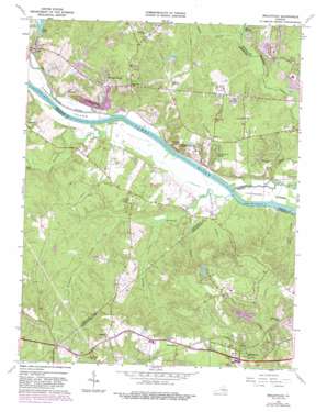
Midlothian Topo Map Virginia
To zoom in, hover over the map of Midlothian
USGS Topo Quad 37077e6 - 1:24,000 scale
| Topo Map Name: | Midlothian |
| USGS Topo Quad ID: | 37077e6 |
| Print Size: | ca. 21 1/4" wide x 27" high |
| Southeast Coordinates: | 37.5° N latitude / 77.625° W longitude |
| Map Center Coordinates: | 37.5625° N latitude / 77.6875° W longitude |
| U.S. State: | VA |
| Filename: | o37077e6.jpg |
| Download Map JPG Image: | Midlothian topo map 1:24,000 scale |
| Map Type: | Topographic |
| Topo Series: | 7.5´ |
| Map Scale: | 1:24,000 |
| Source of Map Images: | United States Geological Survey (USGS) |
| Alternate Map Versions: |
Midlothian VA 1943, updated 1961 Download PDF Buy paper map Midlothian VA 1964, updated 1965 Download PDF Buy paper map Midlothian VA 1964, updated 1972 Download PDF Buy paper map Midlothian VA 1964, updated 1976 Download PDF Buy paper map Midlothian VA 1964, updated 1982 Download PDF Buy paper map Midlothian VA 1964, updated 1987 Download PDF Buy paper map Midlothian VA 1974, updated 1977 Download PDF Buy paper map Midlothian VA 1994, updated 1996 Download PDF Buy paper map Midlothian VA 2010 Download PDF Buy paper map Midlothian VA 2013 Download PDF Buy paper map Midlothian VA 2016 Download PDF Buy paper map |
1:24,000 Topo Quads surrounding Midlothian
> Back to 37077e1 at 1:100,000 scale
> Back to 37076a1 at 1:250,000 scale
> Back to U.S. Topo Maps home
Midlothian topo map: Gazetteer
Midlothian: Dams
Dover Dam elevation 47m 154′Lake Patrick Henry Dam elevation 97m 318′
Salisbury Lake Dam elevation 94m 308′
Midlothian: Islands
Sabot Island elevation 38m 124′Midlothian: Lakes
Blackheath Pond elevation 83m 272′Midlothian: Populated Places
Ashwoods elevation 70m 229′Boscobel elevation 48m 157′
Boscobel Country elevation 74m 242′
Buckingham elevation 119m 390′
Edgehill elevation 65m 213′
Huguenot elevation 71m 232′
Huguenot Hills elevation 67m 219′
Huguenot Springs elevation 65m 213′
James River Estates elevation 70m 229′
Lower Tuckahoe elevation 69m 226′
Manakin elevation 90m 295′
Manakin Farms elevation 75m 246′
Midlothian elevation 111m 364′
Monacan Hill elevation 73m 239′
Pagebrook elevation 60m 196′
Partridge Hills elevation 69m 226′
Pembroke elevation 76m 249′
River Oaks elevation 70m 229′
Sabot elevation 41m 134′
Subletts elevation 75m 246′
Vinita elevation 75m 246′
Midlothian: Post Offices
Manakin Sabot Post Office elevation 88m 288′Midlothian: Reservoirs
Dover Lake elevation 47m 154′Dover Lake elevation 42m 137′
Lake Patrick Henry elevation 97m 318′
Salisbury Lake elevation 94m 308′
Midlothian: Streams
Bernards Creek elevation 38m 124′Broad Branch elevation 44m 144′
Dover Creek elevation 36m 118′
Dutoy Creek elevation 44m 144′
Little River elevation 36m 118′
Marine Spring Branch elevation 38m 124′
Michauk Creek elevation 46m 150′
Norwood Creek elevation 38m 124′
Roberts Branch elevation 42m 137′
Salles Creek elevation 37m 121′
Tuckahoe Creek elevation 39m 127′
Midlothian: Summits
Shooters Hill elevation 69m 226′Midlothian digital topo map on disk
Buy this Midlothian topo map showing relief, roads, GPS coordinates and other geographical features, as a high-resolution digital map file on DVD:
Atlantic Coast (NY, NJ, PA, DE, MD, VA, NC)
Buy digital topo maps: Atlantic Coast (NY, NJ, PA, DE, MD, VA, NC)


