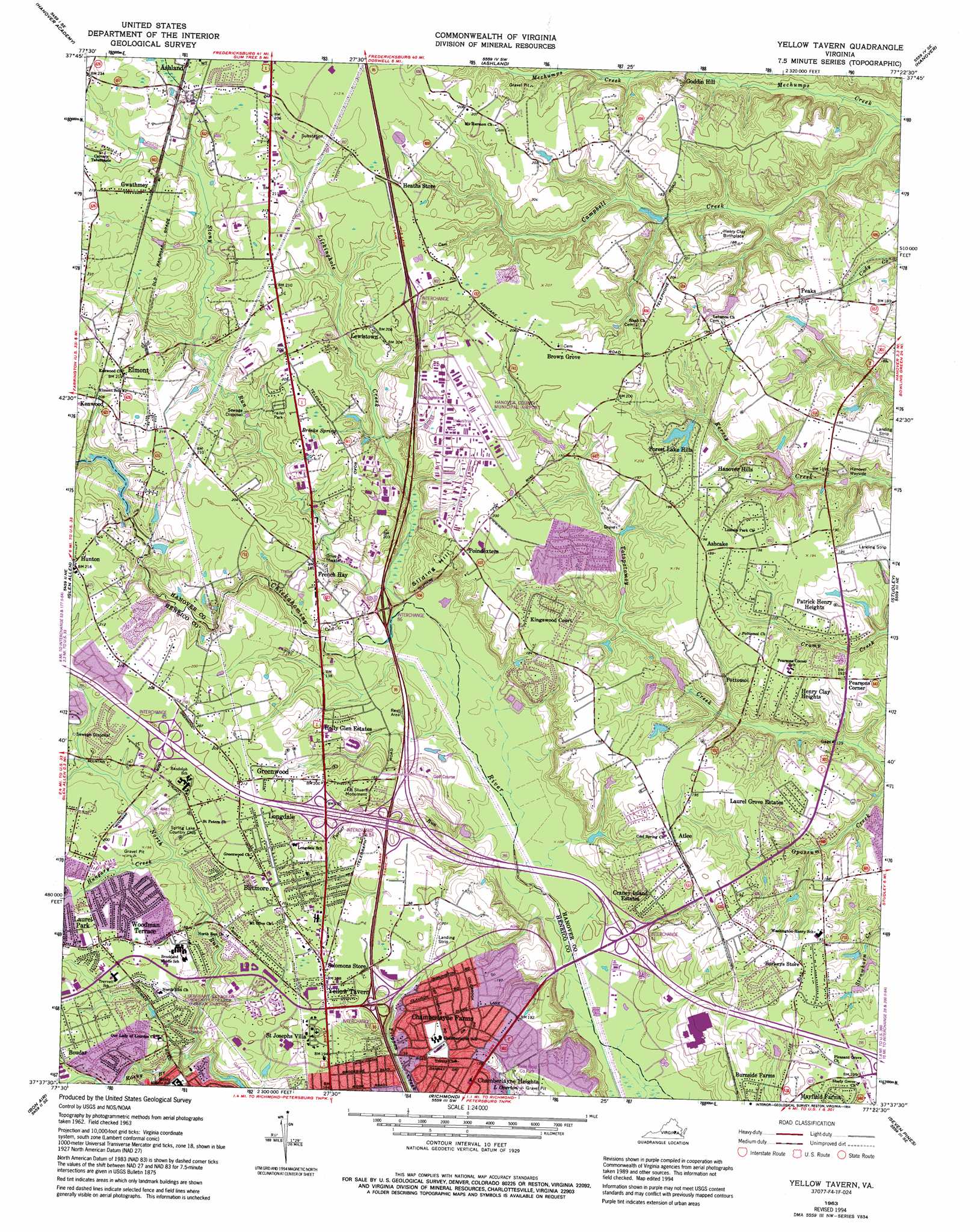
Yellow Tavern Topo Map Virginia
To zoom in, hover over the map of Yellow Tavern
USGS Topo Quad 37077f4 - 1:24,000 scale
| Topo Map Name: | Yellow Tavern |
| USGS Topo Quad ID: | 37077f4 |
| Print Size: | ca. 21 1/4" wide x 27" high |
| Southeast Coordinates: | 37.625° N latitude / 77.375° W longitude |
| Map Center Coordinates: | 37.6875° N latitude / 77.4375° W longitude |
| U.S. State: | VA |
| Filename: | o37077f4.jpg |
| Download Map JPG Image: | Yellow Tavern topo map 1:24,000 scale |
| Map Type: | Topographic |
| Topo Series: | 7.5´ |
| Map Scale: | 1:24,000 |
| Source of Map Images: | United States Geological Survey (USGS) |
| Alternate Map Versions: |
Yellow Tavern VA 1951 Download PDF Buy paper map Yellow Tavern VA 1963, updated 1965 Download PDF Buy paper map Yellow Tavern VA 1963, updated 1969 Download PDF Buy paper map Yellow Tavern VA 1963, updated 1975 Download PDF Buy paper map Yellow Tavern VA 1963, updated 1982 Download PDF Buy paper map Yellow Tavern VA 1963, updated 1987 Download PDF Buy paper map Yellow Tavern VA 1963, updated 1994 Download PDF Buy paper map Yellow Tavern VA 1974, updated 1977 Download PDF Buy paper map Yellow Tavern VA 2010 Download PDF Buy paper map Yellow Tavern VA 2013 Download PDF Buy paper map Yellow Tavern VA 2016 Download PDF Buy paper map |
1:24,000 Topo Quads surrounding Yellow Tavern
Beaverdam |
Hewlett |
Ruther Glen |
Penola |
Sparta |
Montpelier |
Hanover Academy |
Ashland |
Hanover |
Beulahville |
Hylas |
Glen Allen |
Yellow Tavern |
Studley |
Manquin |
Midlothian |
Bon Air |
Richmond |
Seven Pines |
Quinton |
Hallsboro |
Chesterfield |
Drewrys Bluff |
Dutch Gap |
Roxbury |
> Back to 37077e1 at 1:100,000 scale
> Back to 37076a1 at 1:250,000 scale
> Back to U.S. Topo Maps home
Yellow Tavern topo map: Gazetteer
Yellow Tavern: Airports
Hanover Air Park elevation 57m 187′Hanover County Municipal Airport elevation 58m 190′
North Field elevation 62m 203′
Yellow Tavern: Crossings
Interchange 41 elevation 32m 104′Interchange 43 elevation 53m 173′
Interchange 45 elevation 64m 209′
Interchange 83 elevation 58m 190′
Interchange 84 elevation 52m 170′
Interchange 86 elevation 40m 131′
Interchange 89 elevation 66m 216′
Yellow Tavern: Dams
Chickahominy Mill Dam elevation 46m 150′Forest Lake Hills Dam elevation 52m 170′
Miles Dam elevation 46m 150′
Wachter Dam elevation 53m 173′
Walden, Johnon, Nash and Smith Dam elevation 40m 131′
Yellow Tavern: Parks
Carter Park elevation 63m 206′Hanover Wayside elevation 42m 137′
Jeb Stuart Monument elevation 53m 173′
Longdale Recreation Center elevation 65m 213′
North Run Park elevation 57m 187′
Yellow Tavern: Populated Places
Ashcake elevation 59m 193′Atlee elevation 58m 190′
Atlee Manor elevation 59m 193′
Atlee Ridge elevation 64m 209′
Atlee Station elevation 52m 170′
Beechwood Farms elevation 53m 173′
Biltmore elevation 64m 209′
Blue Star Estates elevation 56m 183′
Boudar elevation 61m 200′
Brown Grove elevation 62m 203′
Burnside Farms elevation 53m 173′
Cedar Lane elevation 64m 209′
Chamberlayne elevation 50m 164′
Chamberlayne Farms elevation 56m 183′
Chamberlayne Heights elevation 45m 147′
Colonial Estates Trailer Park elevation 51m 167′
Craney Island Estates elevation 50m 164′
Dellwood elevation 61m 200′
Elmont elevation 63m 206′
Forest Lake Hills elevation 56m 183′
French Hay elevation 53m 173′
Greenwood elevation 62m 203′
Gwathmey elevation 63m 206′
Hanover Heights elevation 60m 196′
Hanover Heights South elevation 59m 193′
Hanover Hills elevation 54m 177′
Heaths Store elevation 64m 209′
Henry Clay Heights elevation 56m 183′
Holly Glen Estates elevation 48m 157′
Holly Ridge elevation 59m 193′
Huntington Heights elevation 57m 187′
Hunton elevation 64m 209′
Kenwood elevation 64m 209′
Kings Charter elevation 59m 193′
Kingswood Court elevation 59m 193′
Knollwood elevation 52m 170′
Kosmo Village Mobile Home Park elevation 60m 196′
Laurel Grove Estates elevation 54m 177′
Laurel Park elevation 63m 206′
Laurel West elevation 58m 190′
Lewistown elevation 63m 206′
Lincoln Park elevation 51m 167′
Longdale elevation 64m 209′
Lydell Heights elevation 57m 187′
Middleton elevation 62m 203′
Mimosa Hills elevation 48m 157′
Mount Hermon Heights elevation 64m 209′
Mountain Laurel elevation 61m 200′
North Run Estates elevation 56m 183′
Northfield elevation 61m 200′
Northwoods elevation 59m 193′
Patrick Henry Heights elevation 53m 173′
Peaks elevation 60m 196′
Pearsons Corner elevation 56m 183′
Poindexters elevation 62m 203′
Pottomoi elevation 47m 154′
Quail Walk elevation 60m 196′
Randolph Ridge elevation 60m 196′
Rapidan Woods elevation 62m 203′
Saint Josephs Villa elevation 61m 200′
Schrader Woods elevation 58m 190′
Sharon Park elevation 58m 190′
Slash Cottage elevation 66m 216′
Solomons Store elevation 58m 190′
Stapleton elevation 59m 193′
Stonewall Manor elevation 53m 173′
Stony Run Estates elevation 52m 170′
Totopotomoy elevation 59m 193′
Twin Oaks elevation 59m 193′
Woodman Terrace elevation 58m 190′
Yellow Tavern elevation 59m 193′
Yellow Tavern: Reservoirs
Forest Hills Lake elevation 52m 170′Wachter Pond elevation 53m 173′
Yellow Tavern: Springs
Brocks Spring elevation 61m 200′Yellow Tavern: Streams
Hungary Creek elevation 51m 167′Lickinghole Creek elevation 35m 114′
Rocky Branch elevation 42m 137′
Stony Run elevation 37m 121′
Stony Run elevation 56m 183′
Turner Run elevation 30m 98′
Yellow Tavern: Summits
Sliding Hill elevation 63m 206′Yellow Tavern digital topo map on disk
Buy this Yellow Tavern topo map showing relief, roads, GPS coordinates and other geographical features, as a high-resolution digital map file on DVD:
Atlantic Coast (NY, NJ, PA, DE, MD, VA, NC)
Buy digital topo maps: Atlantic Coast (NY, NJ, PA, DE, MD, VA, NC)
 map DVD")