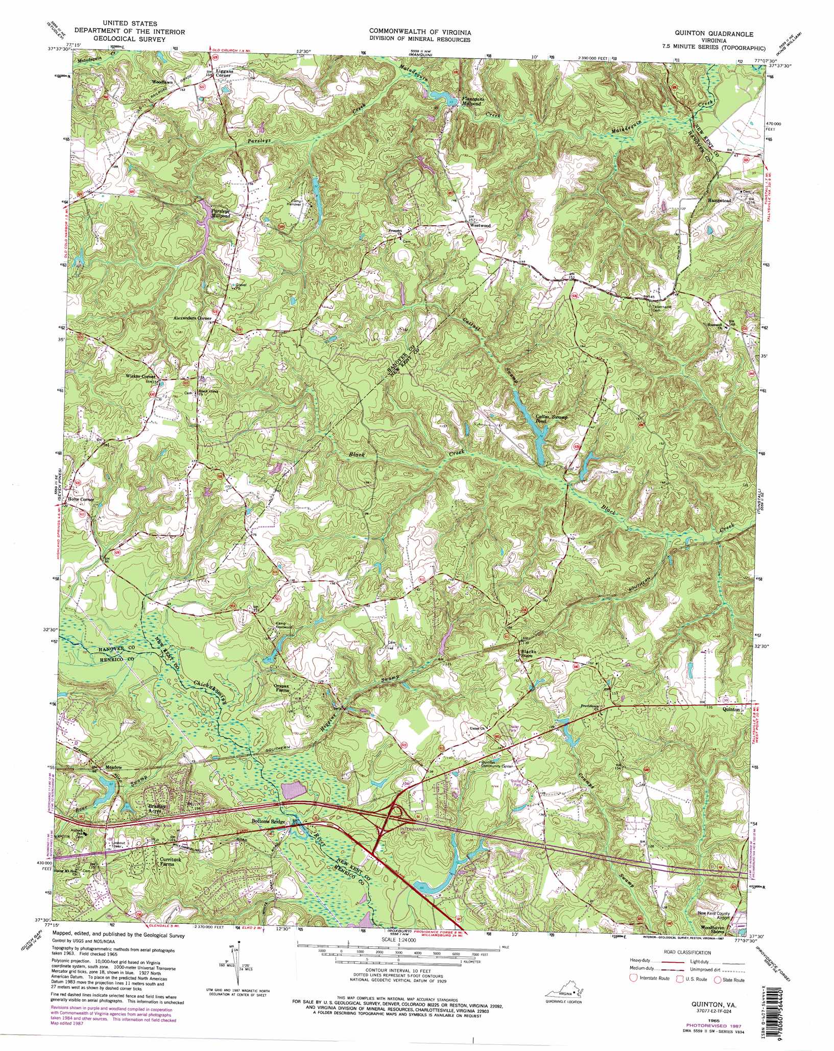
Quinton Topo Map Virginia
To zoom in, hover over the map of Quinton
USGS Topo Quad 37077e2 - 1:24,000 scale
| Topo Map Name: | Quinton |
| USGS Topo Quad ID: | 37077e2 |
| Print Size: | ca. 21 1/4" wide x 27" high |
| Southeast Coordinates: | 37.5° N latitude / 77.125° W longitude |
| Map Center Coordinates: | 37.5625° N latitude / 77.1875° W longitude |
| U.S. State: | VA |
| Filename: | o37077e2.jpg |
| Download Map JPG Image: | Quinton topo map 1:24,000 scale |
| Map Type: | Topographic |
| Topo Series: | 7.5´ |
| Map Scale: | 1:24,000 |
| Source of Map Images: | United States Geological Survey (USGS) |
| Alternate Map Versions: |
Quinton VA 1949 Download PDF Buy paper map Quinton VA 1949 Download PDF Buy paper map Quinton VA 1965, updated 1968 Download PDF Buy paper map Quinton VA 1965, updated 1975 Download PDF Buy paper map Quinton VA 1965, updated 1981 Download PDF Buy paper map Quinton VA 1965, updated 1987 Download PDF Buy paper map Quinton VA 1965, updated 1987 Download PDF Buy paper map Quinton VA 1974, updated 1977 Download PDF Buy paper map Quinton VA 2010 Download PDF Buy paper map Quinton VA 2013 Download PDF Buy paper map Quinton VA 2016 Download PDF Buy paper map |
1:24,000 Topo Quads surrounding Quinton
Ashland |
Hanover |
Beulahville |
Aylett |
Millers Tavern |
Yellow Tavern |
Studley |
Manquin |
King William |
King And Queen Court House |
Richmond |
Seven Pines |
Quinton |
Tunstall |
New Kent |
Drewrys Bluff |
Dutch Gap |
Roxbury |
Providence Forge |
Walkers |
Chester |
Hopewell |
Westover |
Charles City |
Brandon |
> Back to 37077e1 at 1:100,000 scale
> Back to 37076a1 at 1:250,000 scale
> Back to U.S. Topo Maps home
Quinton topo map: Gazetteer
Quinton: Airports
New Kent County Airport elevation 34m 111′Wharton Field elevation 52m 170′
Quinton: Bridges
Bottoms Bridge elevation 17m 55′Quinton: Crossings
Interchange 205 elevation 27m 88′Quinton: Dams
Beaties Millpond Dam elevation 28m 91′Camp Hanover Dam elevation 28m 91′
Cattail Swamp Dam elevation 25m 82′
Eberhard Dam elevation 24m 78′
Parsleys Mill Dam elevation 29m 95′
Tom Brooks Dam elevation 18m 59′
Walden Dam elevation 33m 108′
Quinton: Populated Places
Alexanders Corner elevation 53m 173′Bradley Acres elevation 38m 124′
Cant (historical) elevation 47m 154′
Currituck Farms elevation 48m 157′
Dispatch (historical) elevation 41m 134′
Five Lakes Subdivision elevation 34m 111′
Green Meadows elevation 37m 121′
Hampstead elevation 39m 127′
Holts Corner elevation 38m 124′
Liggans Corner elevation 47m 154′
Northbury elevation 32m 104′
Old Cannon Estates elevation 44m 144′
Orapax Farms elevation 41m 134′
Pine Knoll elevation 52m 170′
Sinclair Manor elevation 46m 150′
Waterloo elevation 46m 150′
Westwood elevation 51m 167′
Whites (historical) elevation 11m 36′
Wicker Corner elevation 49m 160′
Windsor elevation 41m 134′
Woodlawn elevation 45m 147′
Woodview Hills elevation 40m 131′
Quinton: Reservoirs
Beaties Millpond elevation 28m 91′Camp Hanover Lake elevation 28m 91′
Cattail Swamp Pond elevation 21m 68′
Eberhard Pond elevation 24m 78′
Flanagans Millpond elevation 14m 45′
Herman Lake elevation 25m 82′
Parsleys Millpond elevation 29m 95′
Tom Brooks Lake elevation 18m 59′
Walden Pond elevation 33m 108′
Quinton: Streams
Boar Swamp elevation 13m 42′Cattail Swamp elevation 20m 65′
Higgins Swamp elevation 17m 55′
Parsleys Creek elevation 17m 55′
Quinton digital topo map on disk
Buy this Quinton topo map showing relief, roads, GPS coordinates and other geographical features, as a high-resolution digital map file on DVD:
Atlantic Coast (NY, NJ, PA, DE, MD, VA, NC)
Buy digital topo maps: Atlantic Coast (NY, NJ, PA, DE, MD, VA, NC)
 map DVD")