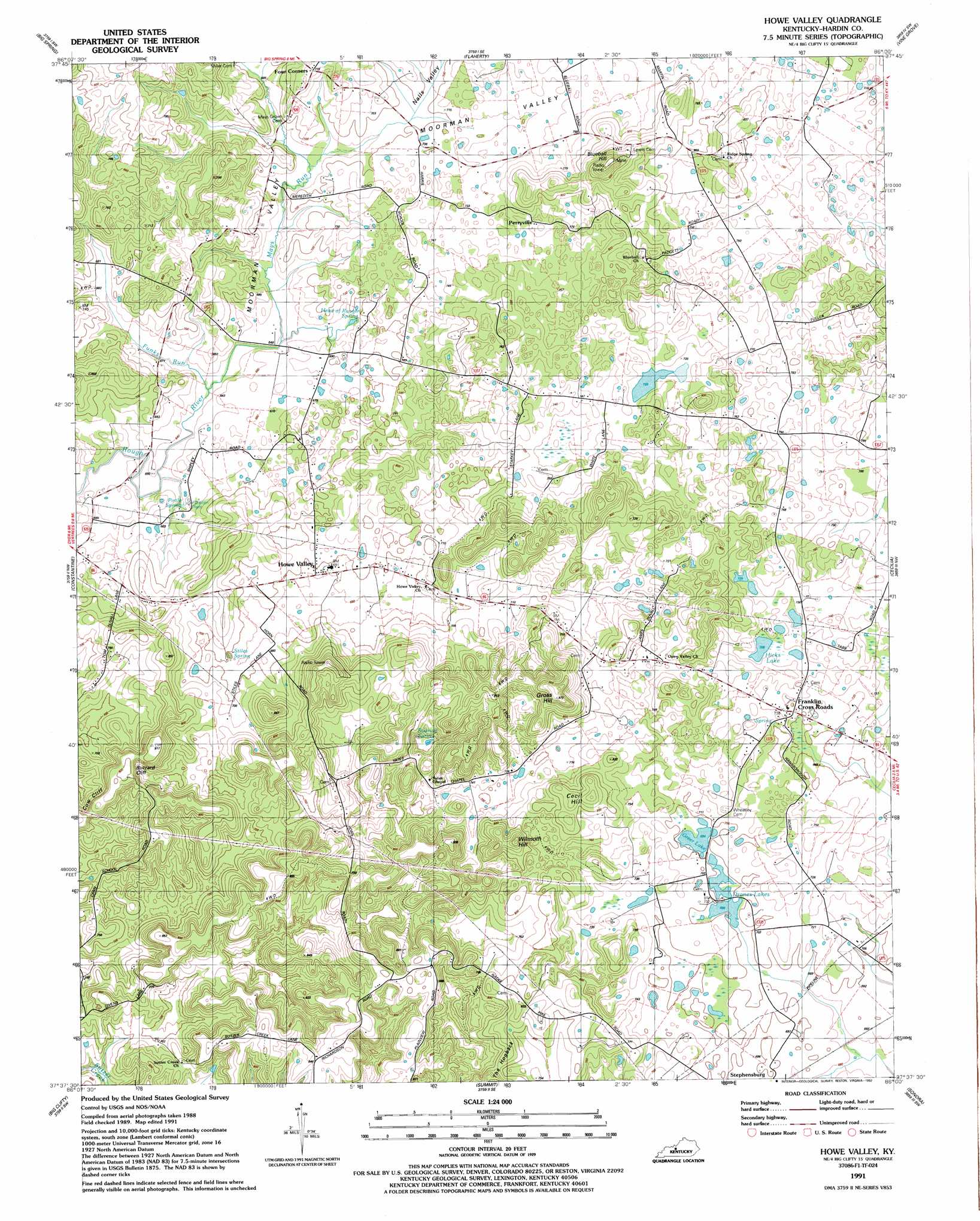
Howe Valley Topo Map Kentucky
To zoom in, hover over the map of Howe Valley
USGS Topo Quad 37086f1 - 1:24,000 scale
| Topo Map Name: | Howe Valley |
| USGS Topo Quad ID: | 37086f1 |
| Print Size: | ca. 21 1/4" wide x 27" high |
| Southeast Coordinates: | 37.625° N latitude / 86° W longitude |
| Map Center Coordinates: | 37.6875° N latitude / 86.0625° W longitude |
| U.S. State: | KY |
| Filename: | o37086f1.jpg |
| Download Map JPG Image: | Howe Valley topo map 1:24,000 scale |
| Map Type: | Topographic |
| Topo Series: | 7.5´ |
| Map Scale: | 1:24,000 |
| Source of Map Images: | United States Geological Survey (USGS) |
| Alternate Map Versions: |
Howe Valley KY 1949, updated 1952 Download PDF Buy paper map Howe Valley KY 1960, updated 1962 Download PDF Buy paper map Howe Valley KY 1991, updated 1992 Download PDF Buy paper map Howe Valley KY 2010 Download PDF Buy paper map Howe Valley KY 2013 Download PDF Buy paper map Howe Valley KY 2016 Download PDF Buy paper map |
1:24,000 Topo Quads surrounding Howe Valley
Irvington |
Guston |
Rock Haven |
Fort Knox |
Pitts Point |
Garfield |
Big Spring |
Flaherty |
Vine Grove |
Colesburg |
Custer |
Constantine |
Howe Valley |
Cecilia |
Elizabethtown |
Madrid |
Big Clifty |
Summit |
Sonora |
Tonieville |
Leitchfield |
Clarkson |
Millerstown |
Upton |
Hammonville |
> Back to 37086e1 at 1:100,000 scale
> Back to 37086a1 at 1:250,000 scale
> Back to U.S. Topo Maps home
Howe Valley topo map: Gazetteer
Howe Valley: Basins
Nalls Valley elevation 231m 757′Howe Valley: Cliffs
Buzzard Cliff elevation 244m 800′Cow Cliff elevation 266m 872′
Howe Valley: Lakes
Dranes elevation 212m 695′Greer Lake elevation 210m 688′
Hicks Lake elevation 216m 708′
Howe Valley: Populated Places
Four Corners elevation 235m 770′Franklin Cross Roads elevation 217m 711′
Howe Valley elevation 208m 682′
Perryville elevation 233m 764′
Howe Valley: Ridges
The Hogback elevation 253m 830′Howe Valley: Springs
Head of Rough Spring elevation 201m 659′Pirtle Spring elevation 194m 636′
Roaring Spring elevation 221m 725′
Stiles Spring elevation 208m 682′
Howe Valley: Streams
Funks Run elevation 192m 629′Mays Run elevation 195m 639′
Howe Valley: Summits
Blueball Hill elevation 304m 997′Cecil Hill elevation 267m 875′
Gross Hill elevation 294m 964′
Wilmoth Hill elevation 276m 905′
Howe Valley: Valleys
Moorman Valley elevation 203m 666′Howe Valley digital topo map on disk
Buy this Howe Valley topo map showing relief, roads, GPS coordinates and other geographical features, as a high-resolution digital map file on DVD: