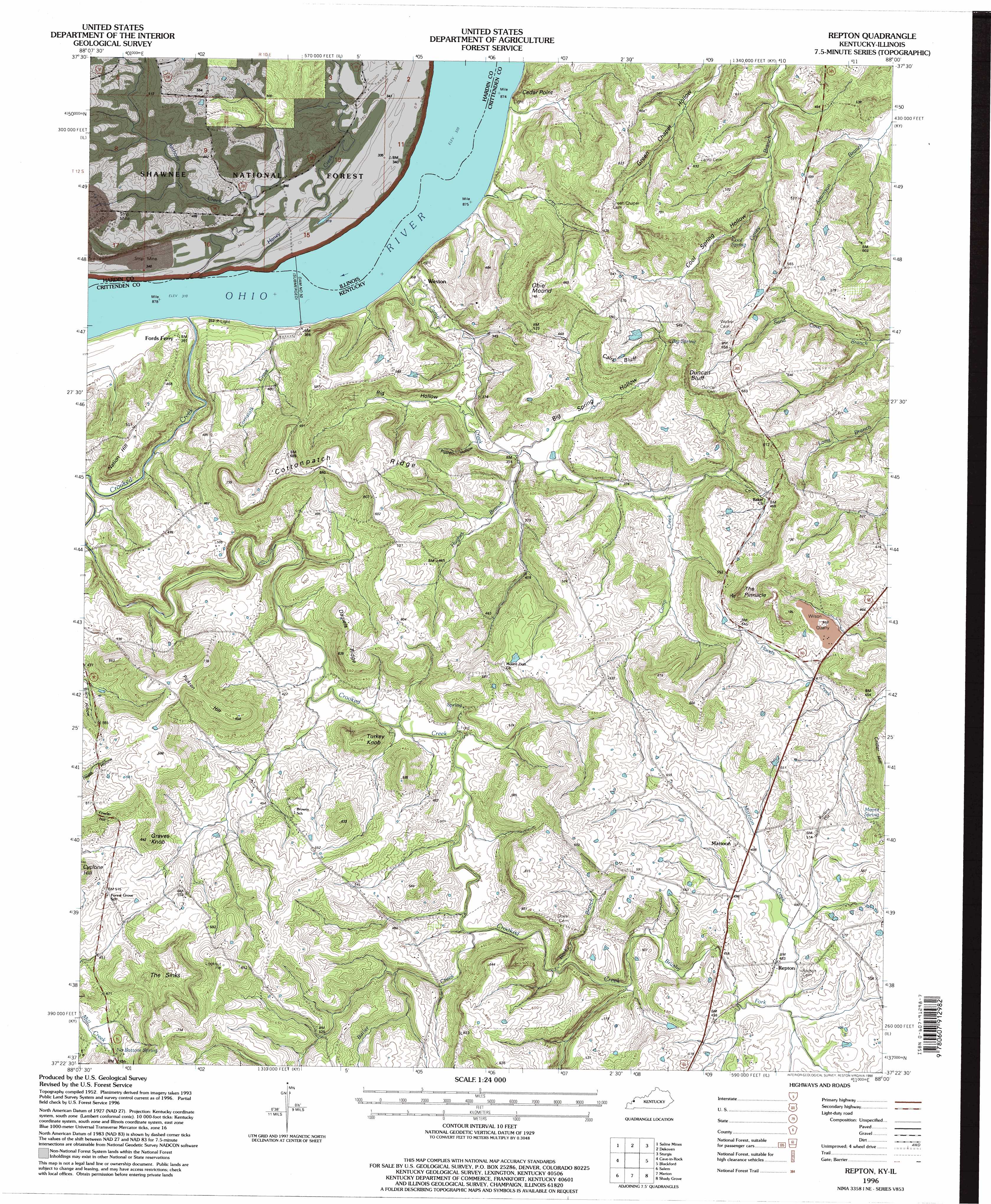
Repton Topo Map Kentucky
To zoom in, hover over the map of Repton
USGS Topo Quad 37088d1 - 1:24,000 scale
| Topo Map Name: | Repton |
| USGS Topo Quad ID: | 37088d1 |
| Print Size: | ca. 21 1/4" wide x 27" high |
| Southeast Coordinates: | 37.375° N latitude / 88° W longitude |
| Map Center Coordinates: | 37.4375° N latitude / 88.0625° W longitude |
| U.S. States: | KY, IL |
| Filename: | o37088d1.jpg |
| Download Map JPG Image: | Repton topo map 1:24,000 scale |
| Map Type: | Topographic |
| Topo Series: | 7.5´ |
| Map Scale: | 1:24,000 |
| Source of Map Images: | United States Geological Survey (USGS) |
| Alternate Map Versions: |
Repton KY 1954, updated 1955 Download PDF Buy paper map Repton KY 1954, updated 1973 Download PDF Buy paper map Repton KY 1954, updated 1990 Download PDF Buy paper map Repton KY 1996, updated 1998 Download PDF Buy paper map Repton KY 2011 Download PDF Buy paper map Repton KY 2013 Download PDF Buy paper map Repton KY 2016 Download PDF Buy paper map |
| FStopo: | US Forest Service topo Repton is available: Download FStopo PDF Download FStopo TIF |
1:24,000 Topo Quads surrounding Repton
Equality |
Shawneetown |
Grove Center |
Morganfield |
Waverley |
Karbers Ridge |
Saline Mines |
Dekoven |
Sturgis |
Bordley |
Rosiclare |
Cave In Rock |
Repton |
Blackford |
Providence |
Lola |
Salem |
Marion |
Shady Grove |
Dalton |
Burna |
Dycusburg |
Fredonia |
Crider |
Olney |
> Back to 37088a1 at 1:100,000 scale
> Back to 37088a1 at 1:250,000 scale
> Back to U.S. Topo Maps home
Repton topo map: Gazetteer
Repton: Basins
The Sinks elevation 137m 449′Repton: Cliffs
Cain Bluff elevation 177m 580′Cedar Point elevation 136m 446′
Duncan Bluff elevation 220m 721′
Repton: Dams
Dam Number 50 elevation 99m 324′Dam Number 50 elevation 99m 324′
Repton: Mines
Wilson Quarry elevation 165m 541′Repton: Pillars
The Pinnacle elevation 232m 761′Repton: Populated Places
Mattoon elevation 156m 511′Repton elevation 149m 488′
Weston elevation 110m 360′
Repton: Ridges
Cottonpatch Ridge elevation 194m 636′Daniels Ridge elevation 186m 610′
Repton: Springs
Moore Spring elevation 162m 531′No Bottom Spring elevation 132m 433′
Repton: Streams
Anthony Creek elevation 99m 324′Brushy Fork elevation 125m 410′
Butler Creek elevation 122m 400′
Camp Creek elevation 99m 324′
Cornstalk Creek elevation 99m 324′
Crooked Creek elevation 99m 324′
Haney Creek elevation 99m 324′
Hughes Branch elevation 108m 354′
Mattoon Creek elevation 140m 459′
Rocky Branch elevation 119m 390′
Repton: Summits
Graves Knob elevation 195m 639′Nation Hill elevation 163m 534′
Obie Mound elevation 226m 741′
Pickren Hill elevation 200m 656′
Turkey Knob elevation 175m 574′
Repton: Valleys
Big Hollow elevation 108m 354′Big Spring Hollow elevation 108m 354′
Cool Spring Hollow elevation 130m 426′
Pigpen Hollow elevation 108m 354′
Repton digital topo map on disk
Buy this Repton topo map showing relief, roads, GPS coordinates and other geographical features, as a high-resolution digital map file on DVD: