Saline Mines Topo Map Illinois
To zoom in, hover over the map of Saline Mines
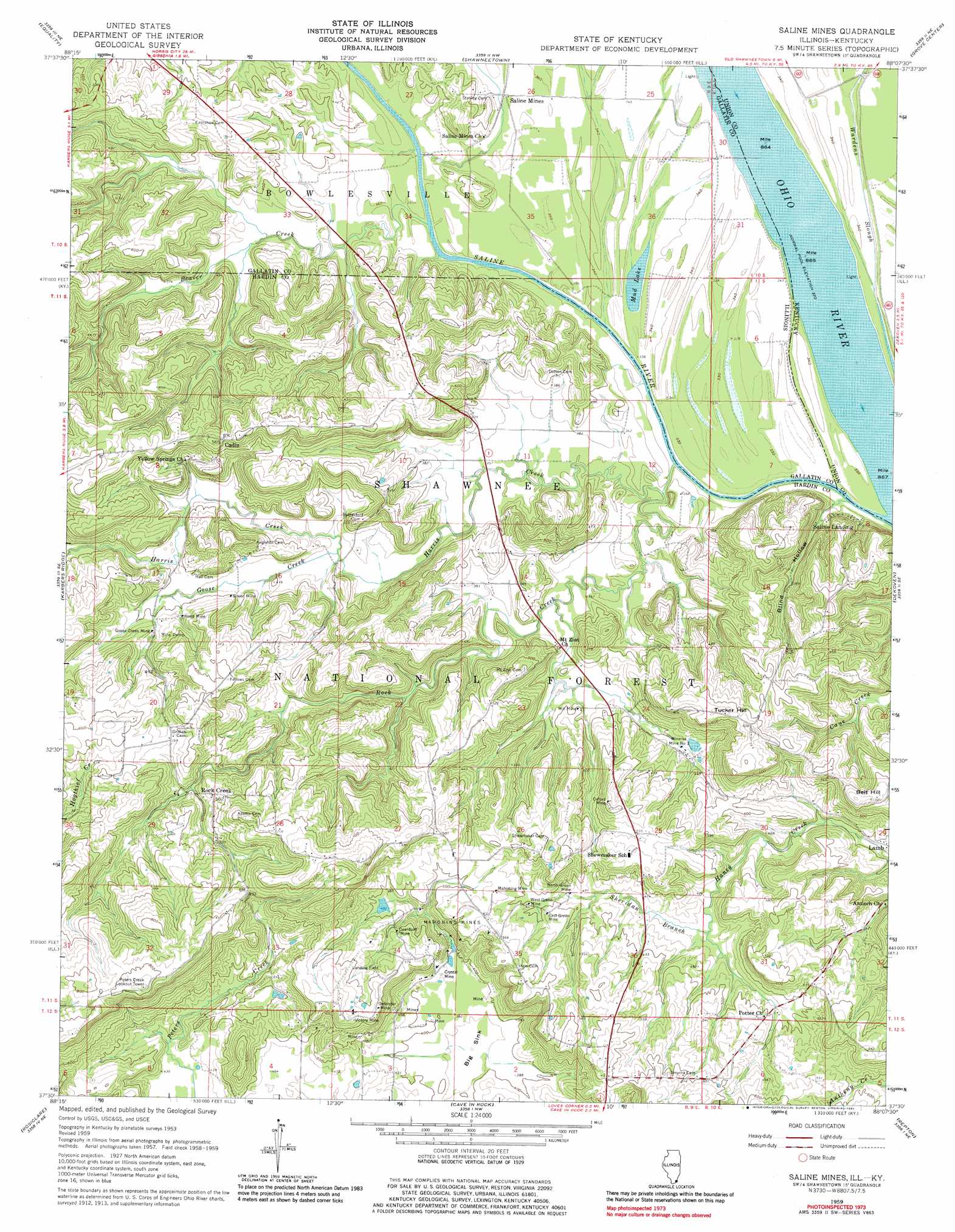
USGS Topo Quad 37088e2 - 1:24,000 scale
| Topo Map Name: | Saline Mines |
| USGS Topo Quad ID: | 37088e2 |
| Print Size: | ca. 21 1/4" wide x 27" high |
| Southeast Coordinates: | 37.5° N latitude / 88.125° W longitude |
| Map Center Coordinates: | 37.5625° N latitude / 88.1875° W longitude |
| U.S. States: | IL, KY |
| Filename: | o37088e2.jpg |
| Download Map JPG Image: | Saline Mines topo map 1:24,000 scale |
| Map Type: | Topographic |
| Topo Series: | 7.5´ |
| Map Scale: | 1:24,000 |
| Source of Map Images: | United States Geological Survey (USGS) |
| Alternate Map Versions: |
Saline Mines IL 1959, updated 1960 Download PDF Buy paper map Saline Mines IL 1959, updated 1969 Download PDF Buy paper map Saline Mines IL 1959, updated 1981 Download PDF Buy paper map Saline Mines IL 1996, updated 1998 Download PDF Buy paper map Saline Mines IL 2011 Download PDF Buy paper map Saline Mines IL 2015 Download PDF Buy paper map |
| FStopo: | US Forest Service topo Saline Mines is available: Download FStopo PDF Download FStopo TIF |
1:24,000 Topo Quads surrounding Saline Mines
Eldorado |
Ridgway |
New Haven Sw |
Wabash Island |
Uniontown |
Rudement |
Equality |
Shawneetown |
Grove Center |
Morganfield |
Herod |
Karbers Ridge |
Saline Mines |
Dekoven |
Sturgis |
Shetlerville |
Rosiclare |
Cave In Rock |
Repton |
Blackford |
Golconda |
Lola |
Salem |
Marion |
Shady Grove |
> Back to 37088e1 at 1:100,000 scale
> Back to 37088a1 at 1:250,000 scale
> Back to U.S. Topo Maps home
Saline Mines topo map: Gazetteer
Saline Mines: Basins
Big Sink elevation 116m 380′Saline Mines: Crossings
Saline Rocks Ferry (historical) elevation 99m 324′Saline Tip Ferry (historical) elevation 100m 328′
Saline Mines: Dams
Schneider Pond Dam elevation 121m 396′Saline Mines: Lakes
Mud Lake elevation 101m 331′Saline Mines: Mines
Crystal Mine elevation 130m 426′Deardorff Mine elevation 155m 508′
Defender Mine elevation 189m 620′
East Green Mine elevation 159m 521′
Goose Creek Mine elevation 128m 419′
Green Mine elevation 131m 429′
Hill Mine elevation 123m 403′
Hoeb Mine elevation 130m 426′
Mahoning Mine elevation 159m 521′
Mahoning Mines elevation 155m 508′
Minerva Mine Number 1 elevation 126m 413′
North Green Mine elevation 144m 472′
Oxford Mine elevation 181m 593′
Victory Mine elevation 195m 639′
West Green Mine elevation 155m 508′
Saline Mines: Populated Places
Cadiz elevation 171m 561′Rock Creek elevation 175m 574′
Saline Landing elevation 116m 380′
Saline Mines: Reservoirs
Schneider Pond elevation 121m 396′Saline Mines: Streams
Beaver Creek elevation 102m 334′Goose Creek elevation 106m 347′
Harris Creek elevation 103m 337′
Rock Creek elevation 103m 337′
Saline River elevation 99m 324′
Sheridan Branch elevation 130m 426′
Saline Mines: Summits
Belt Hill elevation 200m 656′Lead Hill elevation 197m 646′
Tucker Hill elevation 195m 639′
Saline Mines: Trails
Beaver Trail elevation 159m 521′Beaver Trail elevation 112m 367′
River to River Trail elevation 186m 610′
Saline Mines: Valleys
Blind Hollow elevation 104m 341′Hooven Hollow elevation 150m 492′
Saline Mines digital topo map on disk
Buy this Saline Mines topo map showing relief, roads, GPS coordinates and other geographical features, as a high-resolution digital map file on DVD: