Clear Springs Topo Map Missouri
To zoom in, hover over the map of Clear Springs
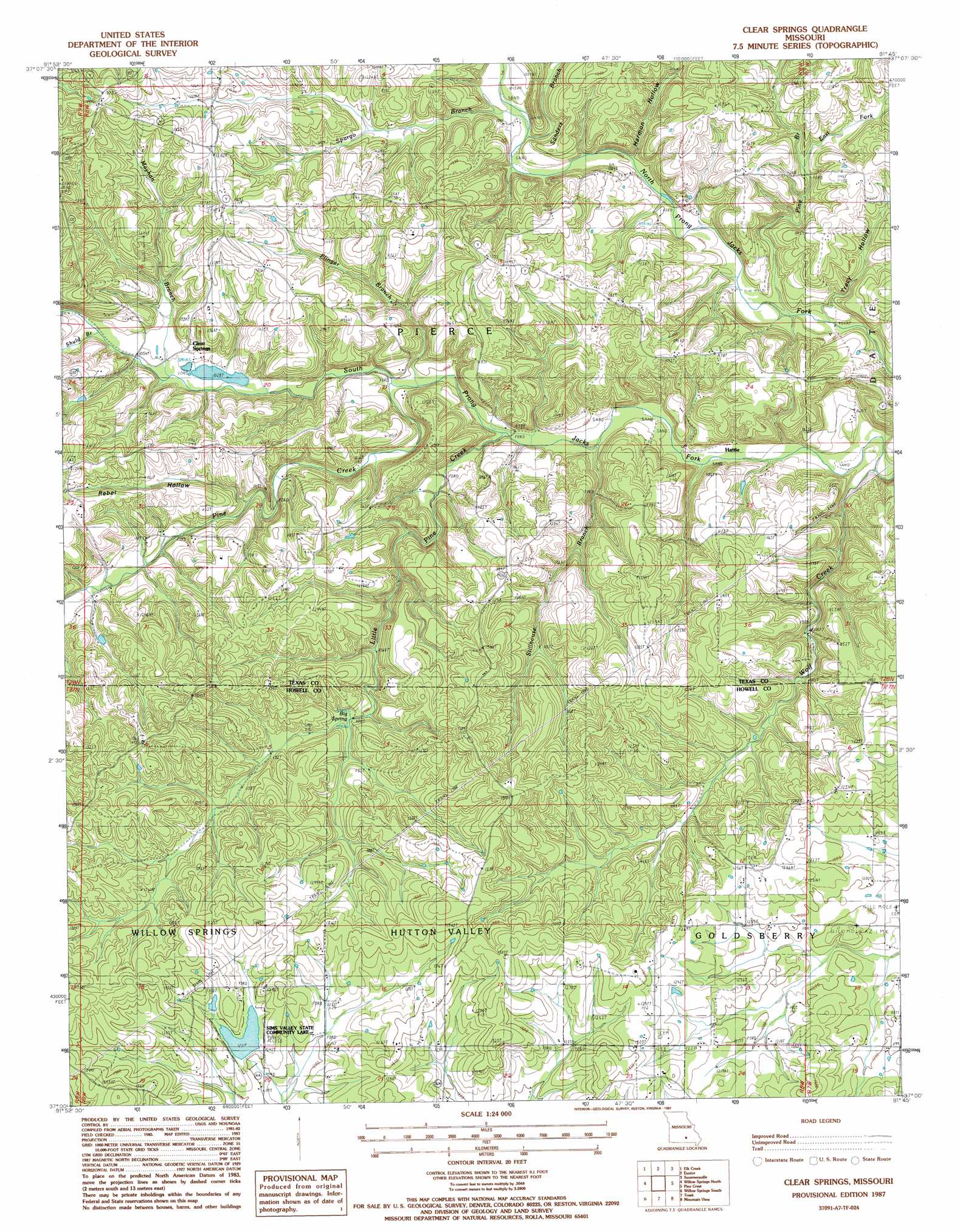
USGS Topo Quad 37091a7 - 1:24,000 scale
| Topo Map Name: | Clear Springs |
| USGS Topo Quad ID: | 37091a7 |
| Print Size: | ca. 21 1/4" wide x 27" high |
| Southeast Coordinates: | 37° N latitude / 91.75° W longitude |
| Map Center Coordinates: | 37.0625° N latitude / 91.8125° W longitude |
| U.S. State: | MO |
| Filename: | o37091a7.jpg |
| Download Map JPG Image: | Clear Springs topo map 1:24,000 scale |
| Map Type: | Topographic |
| Topo Series: | 7.5´ |
| Map Scale: | 1:24,000 |
| Source of Map Images: | United States Geological Survey (USGS) |
| Alternate Map Versions: |
Clear Springs MO 1987, updated 1987 Download PDF Buy paper map Clear Springs MO 2012 Download PDF Buy paper map Clear Springs MO 2015 Download PDF Buy paper map |
1:24,000 Topo Quads surrounding Clear Springs
Bucyrus |
Houston |
Raymondville |
Hartshorn |
Lewis Hollow |
Cabool Ne |
Elk Creek |
Eunice |
Summersville |
Summersville Ne |
Cabool Se |
Willow Springs North |
Clear Springs |
Pine Crest |
Jam Up Cave |
Dyestone Mountain |
Willow Springs South |
Trask |
Mountain View |
Montier |
Siloam Springs |
Pomona |
White Church |
Peace Valley |
Thomasville |
> Back to 37091a1 at 1:100,000 scale
> Back to 37090a1 at 1:250,000 scale
> Back to U.S. Topo Maps home
Clear Springs topo map: Gazetteer
Clear Springs: Dams
Sims Valley Community Lake Dam elevation 372m 1220′Clear Springs: Populated Places
Clear Springs elevation 394m 1292′Guild elevation 366m 1200′
Hattie elevation 308m 1010′
Clear Springs: Post Offices
Hattie Post Office (historical) elevation 315m 1033′Clear Springs: Reservoirs
Sims Valley Community Lake elevation 372m 1220′Sims Valley State Community Lake elevation 373m 1223′
Clear Springs: Springs
Big Spring elevation 339m 1112′Clear Springs: Streams
Big Spring Creek elevation 338m 1108′East Fork Pine Branch elevation 315m 1033′
Flinger Branch elevation 304m 997′
Little Pine Creek elevation 298m 977′
Mayhan Branch elevation 314m 1030′
Pine Branch elevation 293m 961′
Pine Creek elevation 305m 1000′
Sanders Branch elevation 310m 1017′
Shuld Branch elevation 321m 1053′
Spargo Branch elevation 317m 1040′
Stillhouse Branch elevation 293m 961′
Wolf Creek elevation 281m 921′
Clear Springs: Valleys
Harmon Hollow elevation 331m 1085′Rebel Hollow elevation 317m 1040′
Scales Valley elevation 366m 1200′
Tracy Hollow elevation 293m 961′
Clear Springs digital topo map on disk
Buy this Clear Springs topo map showing relief, roads, GPS coordinates and other geographical features, as a high-resolution digital map file on DVD: