Colorado City Topo Map Colorado
To zoom in, hover over the map of Colorado City
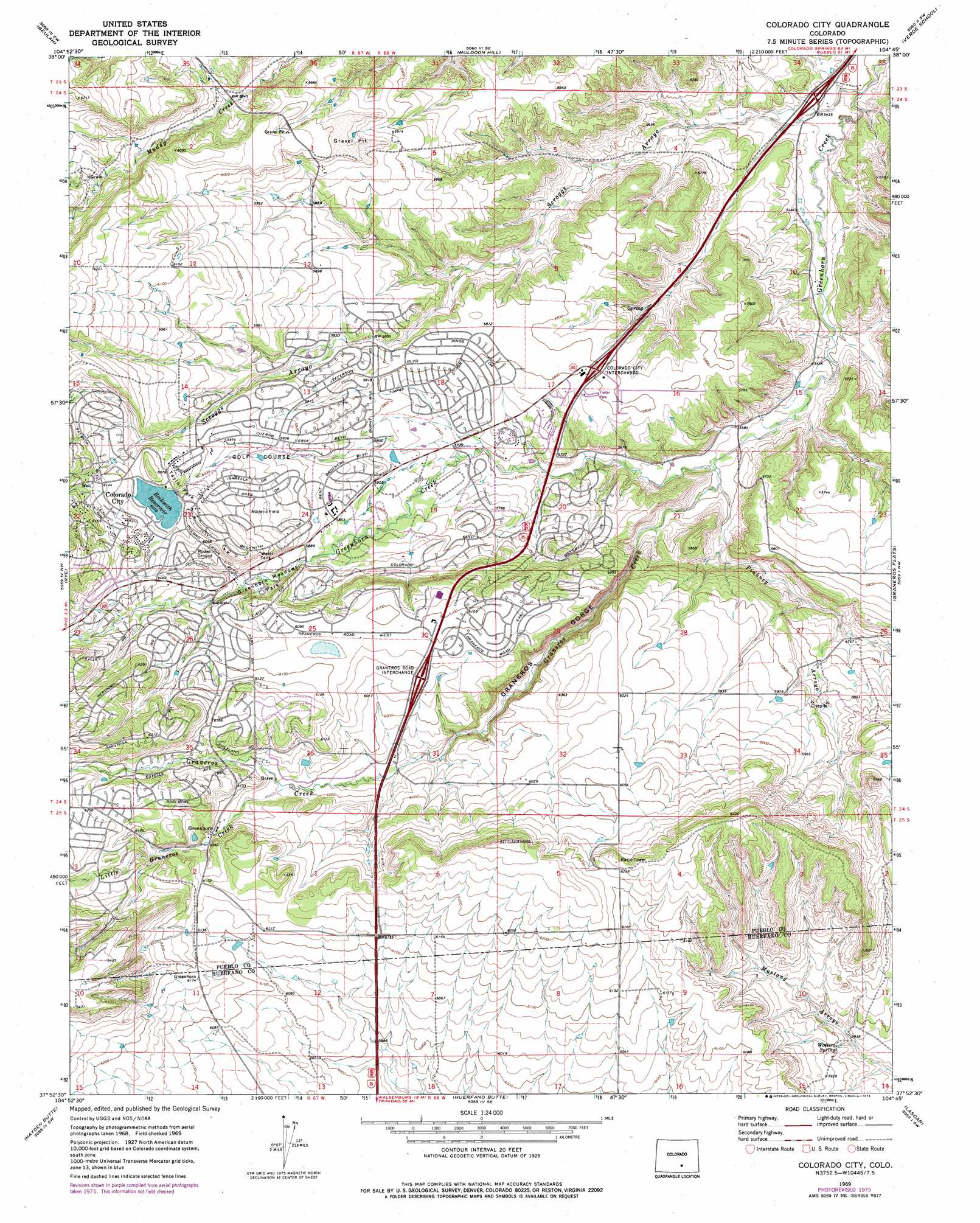
USGS Topo Quad 37104h7 - 1:24,000 scale
| Topo Map Name: | Colorado City |
| USGS Topo Quad ID: | 37104h7 |
| Print Size: | ca. 21 1/4" wide x 27" high |
| Southeast Coordinates: | 37.875° N latitude / 104.75° W longitude |
| Map Center Coordinates: | 37.9375° N latitude / 104.8125° W longitude |
| U.S. State: | CO |
| Filename: | o37104h7.jpg |
| Download Map JPG Image: | Colorado City topo map 1:24,000 scale |
| Map Type: | Topographic |
| Topo Series: | 7.5´ |
| Map Scale: | 1:24,000 |
| Source of Map Images: | United States Geological Survey (USGS) |
| Alternate Map Versions: |
Colorado City CO 1969, updated 1972 Download PDF Buy paper map Colorado City CO 1969, updated 1972 Download PDF Buy paper map Colorado City CO 1969, updated 1976 Download PDF Buy paper map Colorado City CO 2010 Download PDF Buy paper map Colorado City CO 2013 Download PDF Buy paper map Colorado City CO 2016 Download PDF Buy paper map |
1:24,000 Topo Quads surrounding Colorado City
Wetmore |
Owl Canyon |
Beulah Ne |
Southwest Pueblo |
Southeast Pueblo |
Saint Charles Peak |
Beulah |
Muldoon Hill |
Verde School |
Goat Butte |
San Isabel |
Rye |
Colorado City |
Graneros Flats |
Cedarwood |
Badito Cone |
Hayden Butte |
Huerfano Butte |
Lascar |
Capps Springs |
Farisita |
Black Hills |
Walsenburg North |
Maria Reservoir |
Cucharas Reservoir |
> Back to 37104e1 at 1:100,000 scale
> Back to 37104a1 at 1:250,000 scale
> Back to U.S. Topo Maps home
Colorado City topo map: Gazetteer
Colorado City: Airports
Greenhorn Valley Airport elevation 1768m 5800′Colorado City: Dams
Beckwith Dam elevation 1854m 6082′Bonnie Meade Dam elevation 1854m 6082′
Colorado City: Mines
Cedarwood Clay Mine elevation 1824m 5984′Colorado City: Parks
Greenhorn Meadows Park elevation 1801m 5908′Taylor Park elevation 1837m 6026′
Colorado City: Populated Places
Colorado City elevation 1784m 5853′Greenhorn elevation 1856m 6089′
Colorado City: Post Offices
Colorado City Post Office elevation 1787m 5862′Colorado City: Reservoirs
Beckwith Reservoir elevation 1854m 6082′Bonnie Meade Reservoir elevation 1854m 6082′
Colorado City: Springs
Walters Spring elevation 1791m 5875′Colorado City: Streams
Graneros Creek elevation 1698m 5570′Little Graneros Creek elevation 1830m 6003′
Mills Arroyo elevation 1670m 5479′
Pinkney Arroyo elevation 1700m 5577′
Scroggs Arroyo elevation 1642m 5387′
Colorado City: Valleys
Graneros Gorge elevation 1702m 5583′Colorado City digital topo map on disk
Buy this Colorado City topo map showing relief, roads, GPS coordinates and other geographical features, as a high-resolution digital map file on DVD: