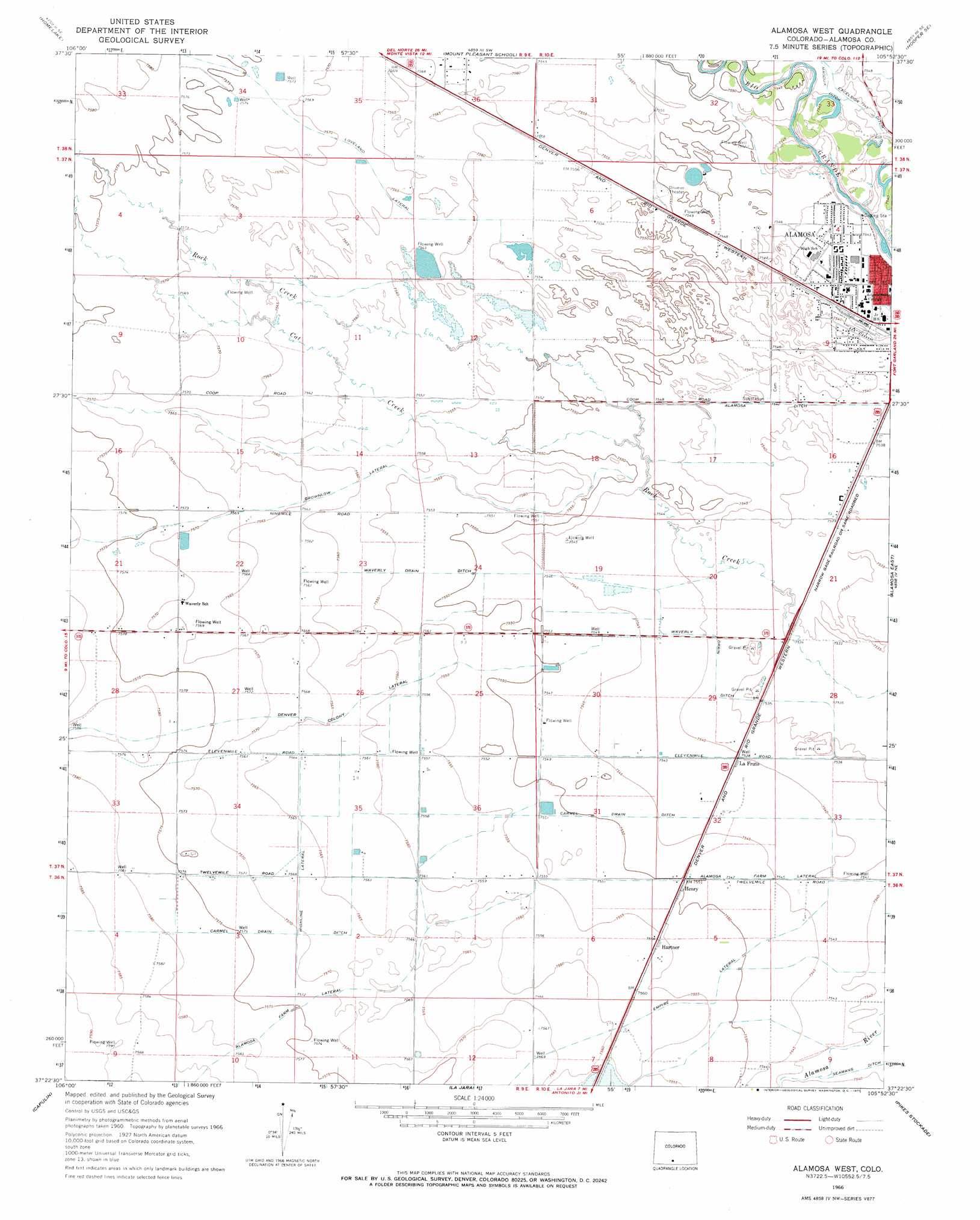
Alamosa West Topo Map Colorado
To zoom in, hover over the map of Alamosa West
USGS Topo Quad 37105d8 - 1:24,000 scale
| Topo Map Name: | Alamosa West |
| USGS Topo Quad ID: | 37105d8 |
| Print Size: | ca. 21 1/4" wide x 27" high |
| Southeast Coordinates: | 37.375° N latitude / 105.875° W longitude |
| Map Center Coordinates: | 37.4375° N latitude / 105.9375° W longitude |
| U.S. State: | CO |
| Filename: | o37105d8.jpg |
| Download Map JPG Image: | Alamosa West topo map 1:24,000 scale |
| Map Type: | Topographic |
| Topo Series: | 7.5´ |
| Map Scale: | 1:24,000 |
| Source of Map Images: | United States Geological Survey (USGS) |
| Alternate Map Versions: |
Alamosa West CO 1966, updated 1969 Download PDF Buy paper map Alamosa West CO 1966, updated 1969 Download PDF Buy paper map Alamosa West CO 1966, updated 1971 Download PDF Buy paper map Alamosa West CO 2010 Download PDF Buy paper map Alamosa West CO 2013 Download PDF Buy paper map Alamosa West CO 2016 Download PDF Buy paper map |
1:24,000 Topo Quads surrounding Alamosa West
Sevenmile Plaza |
Center South |
Hooper West |
Hooper East |
Medano Ranch |
Monte Vista |
Homelake |
Mount Pleasant School |
Hooper Se |
Dry Lakes |
Fulcher Gulch |
Waverly |
Alamosa West |
Alamosa East |
Baldy |
Centro |
Capulin |
La Jara |
Pikes Stockade |
Lasauses |
Vicente Canyon |
Goshawk Dam |
Manassa |
Manassa Ne |
Mesito Reservoir |
> Back to 37105a1 at 1:100,000 scale
> Back to 37104a1 at 1:250,000 scale
> Back to U.S. Topo Maps home
Alamosa West topo map: Gazetteer
Alamosa West: Canals
Alamosa Farm Lateral elevation 2304m 7559′Brownlow Lateral elevation 2306m 7565′
Carmel Drain Ditch elevation 2305m 7562′
Denver Colony Lateral elevation 2307m 7568′
Waverly Drain Ditch elevation 2298m 7539′
Alamosa West: Mines
Harmony Pit elevation 2300m 7545′Alamosa West: Populated Places
Hartner elevation 2304m 7559′Henry elevation 2303m 7555′
La Fruto elevation 2300m 7545′
Alamosa West: Streams
Cat Creek elevation 2301m 7549′Alamosa West digital topo map on disk
Buy this Alamosa West topo map showing relief, roads, GPS coordinates and other geographical features, as a high-resolution digital map file on DVD: