Feliciana Mountain Topo Map California
To zoom in, hover over the map of Feliciana Mountain
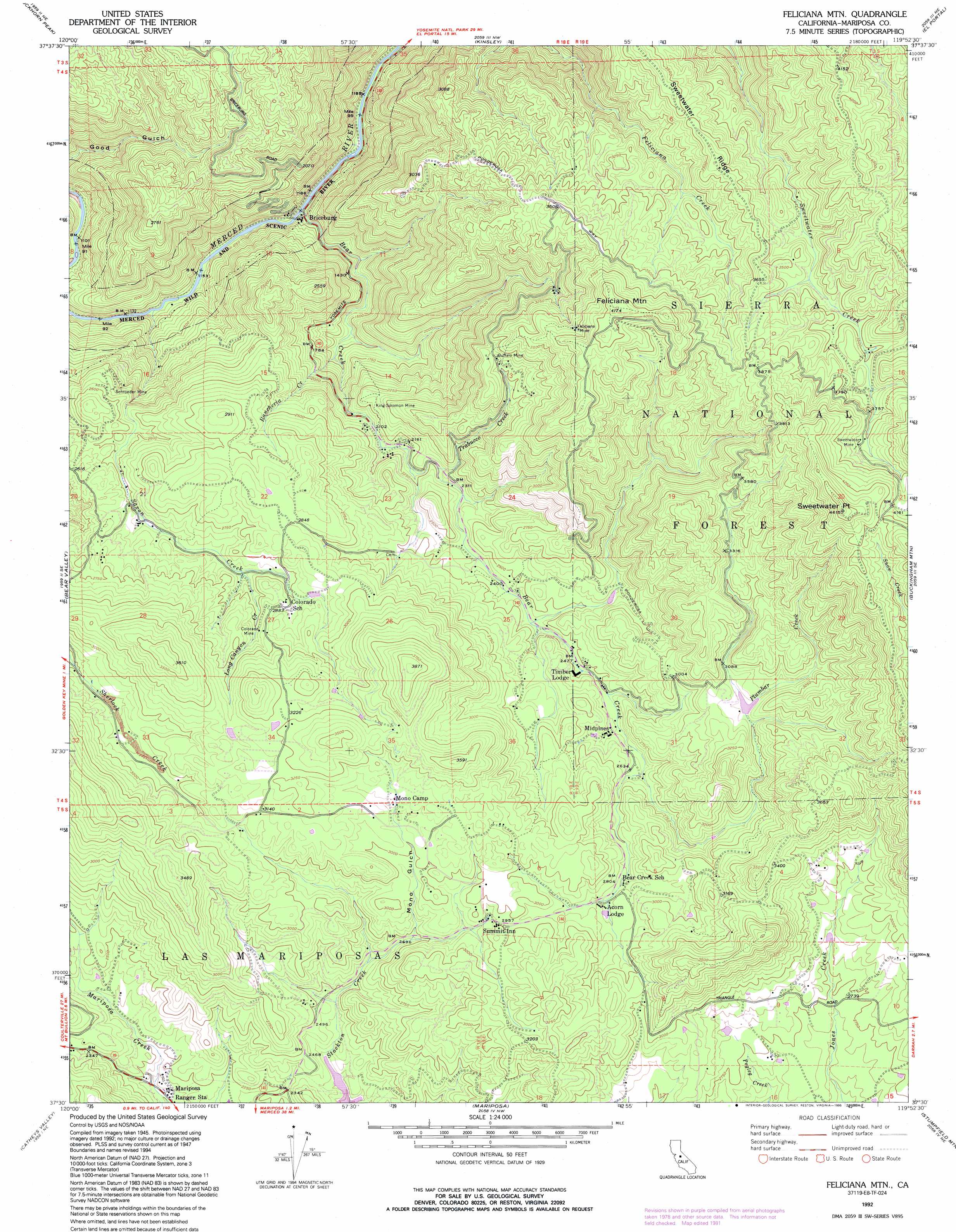
USGS Topo Quad 37119e8 - 1:24,000 scale
| Topo Map Name: | Feliciana Mountain |
| USGS Topo Quad ID: | 37119e8 |
| Print Size: | ca. 21 1/4" wide x 27" high |
| Southeast Coordinates: | 37.5° N latitude / 119.875° W longitude |
| Map Center Coordinates: | 37.5625° N latitude / 119.9375° W longitude |
| U.S. State: | CA |
| Filename: | o37119e8.jpg |
| Download Map JPG Image: | Feliciana Mountain topo map 1:24,000 scale |
| Map Type: | Topographic |
| Topo Series: | 7.5´ |
| Map Scale: | 1:24,000 |
| Source of Map Images: | United States Geological Survey (USGS) |
| Alternate Map Versions: |
Feliciana Mtn. CA 1947, updated 1965 Download PDF Buy paper map Feliciana Mtn. CA 1947, updated 1971 Download PDF Buy paper map Feliciana Mtn. CA 1947, updated 1981 Download PDF Buy paper map Feliciana Mtn. CA 1948, updated 1948 Download PDF Buy paper map Feliciana Mtn. CA 1992, updated 1995 Download PDF Buy paper map Feliciana Mountain CA 2004, updated 2007 Download PDF Buy paper map Feliciana Mountain CA 2012 Download PDF Buy paper map Feliciana Mountain CA 2015 Download PDF Buy paper map |
| FStopo: | US Forest Service topo Feliciana Mountain is available: Download FStopo PDF Download FStopo TIF |
1:24,000 Topo Quads surrounding Feliciana Mountain
Groveland |
Jawbone Ridge |
Ascension Mountain |
Ackerson Mountain |
Tamarack Flat |
Coulterville |
Buckhorn Peak |
Kinsley |
El Portal |
El Capitan |
Hornitos |
Bear Valley |
Feliciana Mountain |
Buckingham Mountain |
Wawona |
Indian Gulch |
Catheys Valley |
Mariposa |
Stumpfield Mountain |
Fish Camp |
Owens Reservoir |
Illinois Hill |
Ben Hur |
Horsecamp Mountain |
Ahwahnee |
> Back to 37119e1 at 1:100,000 scale
> Back to 37118a1 at 1:250,000 scale
> Back to U.S. Topo Maps home
Feliciana Mountain topo map: Gazetteer
Feliciana Mountain: Mines
Buffalo Mine elevation 961m 3152′Colorado Mine elevation 882m 2893′
Feliciana Mine elevation 1118m 3667′
King Solomon Mine elevation 696m 2283′
Schroeder Mine elevation 673m 2208′
Sweetwater Mine elevation 1160m 3805′
Feliciana Mountain: Parks
Midpines Park elevation 856m 2808′Feliciana Mountain: Populated Places
Briceburg elevation 347m 1138′Midpines elevation 788m 2585′
Feliciana Mountain: Ridges
Sweetwater Ridge elevation 1116m 3661′Feliciana Mountain: Streams
Bear Creek elevation 355m 1164′Long Canyon Creek elevation 799m 2621′
Plumbar Creek elevation 793m 2601′
Rancheria Creek elevation 460m 1509′
Saxon Creek elevation 325m 1066′
Trabucco Creek elevation 699m 2293′
Feliciana Mountain: Summits
Feliciana Mountain elevation 1250m 4101′Sweetwater Point elevation 1406m 4612′
Feliciana Mountain: Valleys
Mono Gulch elevation 823m 2700′Feliciana Mountain digital topo map on disk
Buy this Feliciana Mountain topo map showing relief, roads, GPS coordinates and other geographical features, as a high-resolution digital map file on DVD: