Hornitos Topo Map California
To zoom in, hover over the map of Hornitos
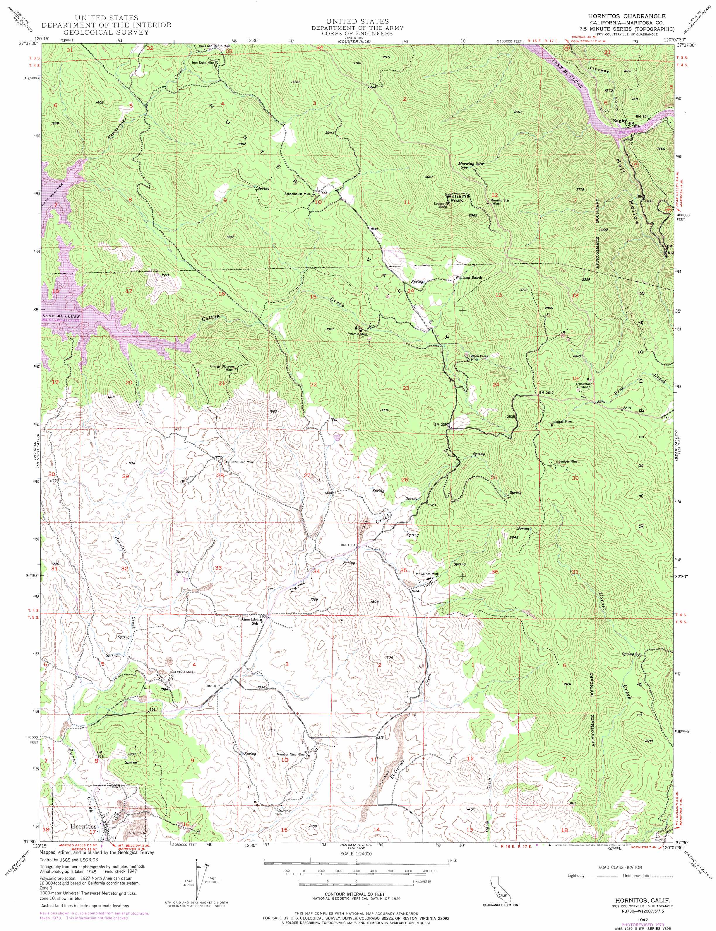
USGS Topo Quad 37120e2 - 1:24,000 scale
| Topo Map Name: | Hornitos |
| USGS Topo Quad ID: | 37120e2 |
| Print Size: | ca. 21 1/4" wide x 27" high |
| Southeast Coordinates: | 37.5° N latitude / 120.125° W longitude |
| Map Center Coordinates: | 37.5625° N latitude / 120.1875° W longitude |
| U.S. State: | CA |
| Filename: | o37120e2.jpg |
| Download Map JPG Image: | Hornitos topo map 1:24,000 scale |
| Map Type: | Topographic |
| Topo Series: | 7.5´ |
| Map Scale: | 1:24,000 |
| Source of Map Images: | United States Geological Survey (USGS) |
| Alternate Map Versions: |
Hornitos CA 1947, updated 1964 Download PDF Buy paper map Hornitos CA 1947, updated 1973 Download PDF Buy paper map Hornitos CA 1947, updated 1977 Download PDF Buy paper map Hornitos CA 1949 Download PDF Buy paper map Hornitos CA 2012 Download PDF Buy paper map Hornitos CA 2015 Download PDF Buy paper map |
1:24,000 Topo Quads surrounding Hornitos
Chinese Camp |
Moccasin |
Groveland |
Jawbone Ridge |
Ascension Mountain |
La Grange |
Penon Blanco Peak |
Coulterville |
Buckhorn Peak |
Kinsley |
Snelling |
Merced Falls |
Hornitos |
Bear Valley |
Feliciana Mountain |
Yosemite Lake |
Haystack Mountain |
Indian Gulch |
Catheys Valley |
Mariposa |
Merced |
Planada |
Owens Reservoir |
Illinois Hill |
Ben Hur |
> Back to 37120e1 at 1:100,000 scale
> Back to 37120a1 at 1:250,000 scale
> Back to U.S. Topo Maps home
Hornitos topo map: Gazetteer
Hornitos: Bays
Cotton Arm elevation 251m 823′Hornitos: Mines
Brill and Herley Prospect elevation 402m 1318′Cotton Creek Mine elevation 525m 1722′
Iron Duke Mine elevation 473m 1551′
Juniper Mine elevation 917m 3008′
Juniper Mine elevation 814m 2670′
Morning Star Mine elevation 814m 2670′
Mount Gaines Mine elevation 460m 1509′
Number Nine Mine elevation 352m 1154′
Oaks and Reese Mine elevation 479m 1571′
Orange Blossom Mine elevation 427m 1400′
Pyramid Mine elevation 482m 1581′
Queen Specimen Mine elevation 451m 1479′
Red Cloud Mines elevation 318m 1043′
Schoolhouse Mine elevation 528m 1732′
Silver-Lead Mine elevation 382m 1253′
Yellowstone Mine elevation 730m 2395′
Hornitos: Parks
Bagby Recreation Area elevation 259m 849′Hornitos Park elevation 257m 843′
Hornitos: Populated Places
Bagby elevation 253m 830′Hornitos elevation 257m 843′
Hornitos: Post Offices
Hornitos Post Office elevation 257m 843′Hornitos: Ridges
Juniper Ridge elevation 946m 3103′Hornitos: Springs
Morning Star Spring elevation 731m 2398′Hornitos: Streams
Cotton Creek elevation 269m 882′Hornitos Creek elevation 262m 859′
Temperance Creek elevation 251m 823′
Hornitos: Summits
Williams Peak elevation 942m 3090′Hornitos: Valleys
Flyaway Gulch elevation 258m 846′Hell Hollow elevation 252m 826′
Hunter Valley elevation 516m 1692′
Hornitos digital topo map on disk
Buy this Hornitos topo map showing relief, roads, GPS coordinates and other geographical features, as a high-resolution digital map file on DVD: