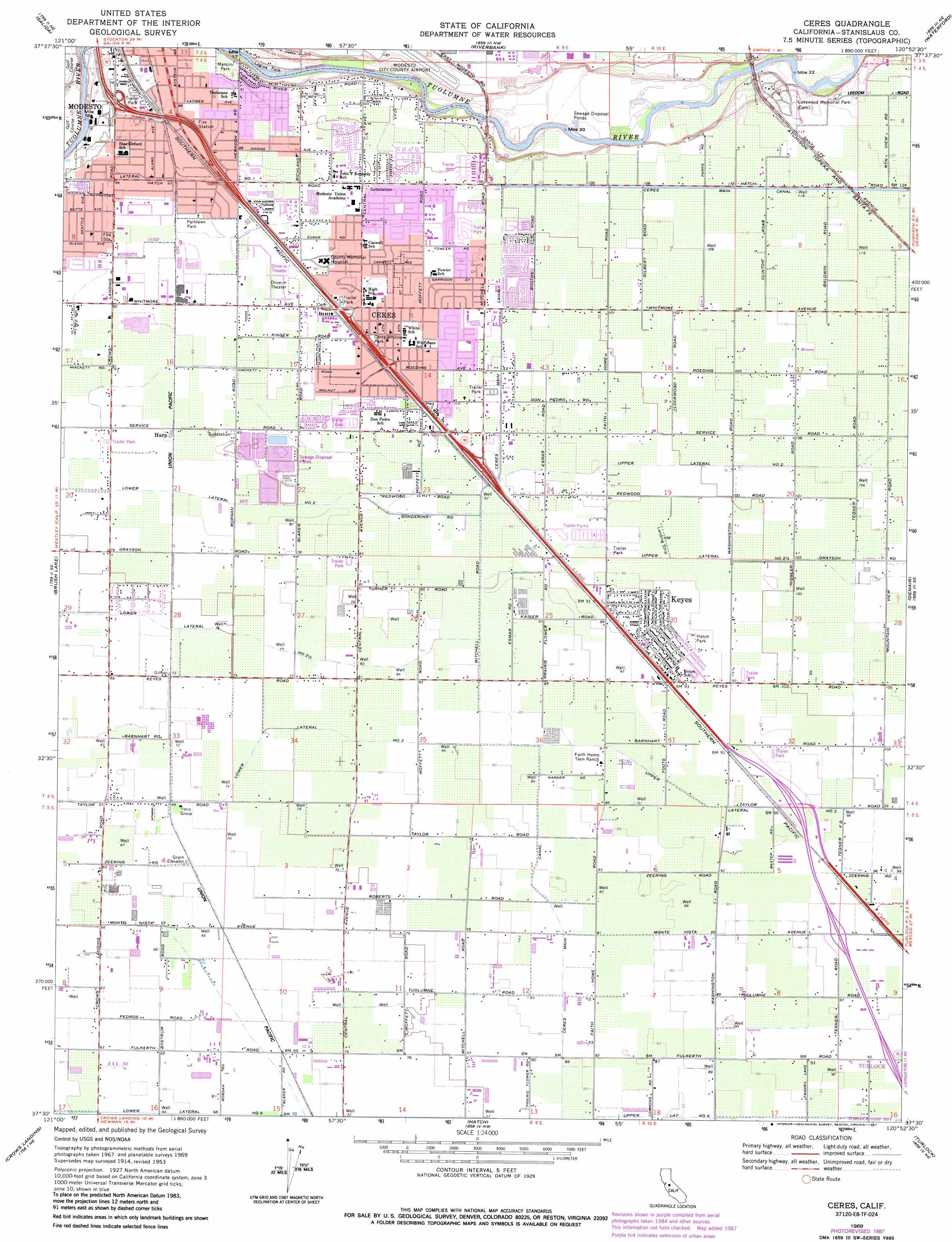
Ceres Topo Map California
To zoom in, hover over the map of Ceres
USGS Topo Quad 37120e8 - 1:24,000 scale
| Topo Map Name: | Ceres |
| USGS Topo Quad ID: | 37120e8 |
| Print Size: | ca. 21 1/4" wide x 27" high |
| Southeast Coordinates: | 37.5° N latitude / 120.875° W longitude |
| Map Center Coordinates: | 37.5625° N latitude / 120.9375° W longitude |
| U.S. State: | CA |
| Filename: | o37120e8.jpg |
| Download Map JPG Image: | Ceres topo map 1:24,000 scale |
| Map Type: | Topographic |
| Topo Series: | 7.5´ |
| Map Scale: | 1:24,000 |
| Source of Map Images: | United States Geological Survey (USGS) |
| Alternate Map Versions: |
Ceres CA 1953, updated 1954 Download PDF Buy paper map Ceres CA 1953, updated 1954 Download PDF Buy paper map Ceres CA 1969, updated 1971 Download PDF Buy paper map Ceres CA 1969, updated 1971 Download PDF Buy paper map Ceres CA 1969, updated 1978 Download PDF Buy paper map Ceres CA 1969, updated 1978 Download PDF Buy paper map Ceres CA 1969, updated 1987 Download PDF Buy paper map Ceres CA 2012 Download PDF Buy paper map Ceres CA 2015 Download PDF Buy paper map |
1:24,000 Topo Quads surrounding Ceres
Manteca |
Avena |
Escalon |
Oakdale |
Knights Ferry |
Ripon |
Salida |
Riverbank |
Waterford |
Paulsell |
Westley |
Brush Lake |
Ceres |
Denair |
Montpelier |
Patterson |
Crows Landing |
Hatch |
Turlock |
Cressey |
Orestimba Peak |
Newman |
Gustine |
Stevinson |
Arena |
> Back to 37120e1 at 1:100,000 scale
> Back to 37120a1 at 1:250,000 scale
> Back to U.S. Topo Maps home
Ceres topo map: Gazetteer
Ceres: Canals
Lower Lateral Number Four elevation 19m 62′Lower Lateral Number Three elevation 25m 82′
Upper Lateral Number Four elevation 29m 95′
Ceres: Parks
Atch Pedretti Park elevation 30m 98′Berry Grove Park elevation 30m 98′
Ceres-Whitmore Park elevation 32m 104′
Hatch Park elevation 29m 95′
Independence Park elevation 28m 91′
Legion Park elevation 19m 62′
Mancini Park elevation 28m 91′
Parklawn Park elevation 27m 88′
Persehone Park elevation 30m 98′
Redwood Park elevation 28m 91′
Roeding Heights Park elevation 29m 95′
Smyrna Park elevation 29m 95′
Ceres: Populated Places
Bystrom elevation 27m 88′Ceres elevation 28m 91′
Esmar (historical) elevation 29m 95′
Harp elevation 25m 82′
Keyes elevation 28m 91′
Shackelford elevation 25m 82′
Ceres: Post Offices
Ceres Post Office elevation 28m 91′Ceres: Woods
Yoris Grove elevation 21m 68′Ceres digital topo map on disk
Buy this Ceres topo map showing relief, roads, GPS coordinates and other geographical features, as a high-resolution digital map file on DVD: