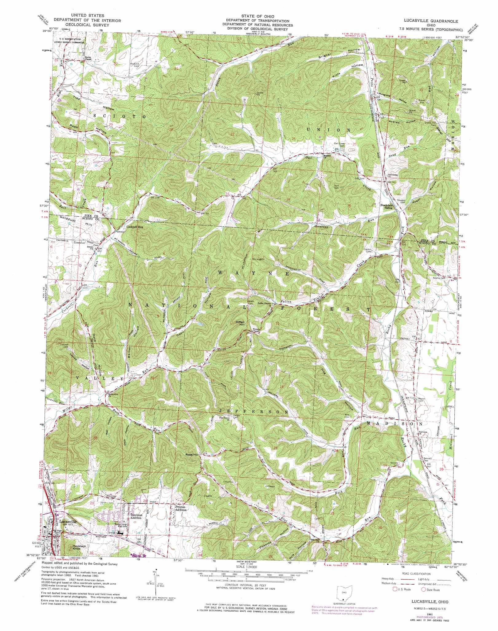
Lucasville Topo Map Ohio
To zoom in, hover over the map of Lucasville
USGS Topo Quad 38082h8 - 1:24,000 scale
| Topo Map Name: | Lucasville |
| USGS Topo Quad ID: | 38082h8 |
| Print Size: | ca. 21 1/4" wide x 27" high |
| Southeast Coordinates: | 38.875° N latitude / 82.875° W longitude |
| Map Center Coordinates: | 38.9375° N latitude / 82.9375° W longitude |
| U.S. State: | OH |
| Filename: | o38082h8.jpg |
| Download Map JPG Image: | Lucasville topo map 1:24,000 scale |
| Map Type: | Topographic |
| Topo Series: | 7.5´ |
| Map Scale: | 1:24,000 |
| Source of Map Images: | United States Geological Survey (USGS) |
| Alternate Map Versions: |
Lucasville OH 1961, updated 1962 Download PDF Buy paper map Lucasville OH 1961, updated 1977 Download PDF Buy paper map Lucasville OH 1961, updated 1977 Download PDF Buy paper map Lucasville OH 2010 Download PDF Buy paper map Lucasville OH 2013 Download PDF Buy paper map Lucasville OH 2016 Download PDF Buy paper map |
1:24,000 Topo Quads surrounding Lucasville
Morgantown |
Summithill |
Waverly North |
Richmond Dale |
Byer |
Latham |
Piketon |
Waverly South |
Beaver |
Jackson |
Rarden |
Wakefield |
Lucasville |
Stockdale |
Petersburg |
Otway |
West Portsmouth |
New Boston |
Minford |
South Webster |
Pond Run |
Friendship |
Portsmouth |
Wheelersburg |
Pedro |
> Back to 38082e1 at 1:100,000 scale
> Back to 38082a1 at 1:250,000 scale
> Back to U.S. Topo Maps home
Lucasville topo map: Gazetteer
Lucasville: Populated Places
Cockrell Run elevation 208m 682′Lucasville elevation 167m 547′
Preston Addition elevation 223m 731′
Tomlison Addition elevation 207m 679′
Lucasville: Post Offices
Lucasville Post Office elevation 166m 544′Lucasville: Streams
Back Run elevation 195m 639′Blue Run elevation 188m 616′
Buck Run elevation 207m 679′
Bull Run elevation 201m 659′
Cockrell Run elevation 172m 564′
Fallen Timber Creek elevation 213m 698′
Hockenberry Hollow elevation 175m 574′
Hunting Run elevation 213m 698′
Owl Creek elevation 214m 702′
Sand Run elevation 213m 698′
Lucasville: Summits
Diffen Hill elevation 332m 1089′Gravel Hill elevation 306m 1003′
Haystack Knob elevation 279m 915′
Rose Hill elevation 334m 1095′
Lucasville: Valleys
Andrew Hollow elevation 225m 738′Barker Hollow elevation 184m 603′
Brigner Hollow elevation 207m 679′
Cook Hollow elevation 196m 643′
Coon Hollow elevation 189m 620′
Dace Hollow elevation 177m 580′
Hockenberry Hollow elevation 180m 590′
Hog Hollow elevation 207m 679′
Howards Hollow elevation 228m 748′
Koger Hollow elevation 217m 711′
Luckett Hollow elevation 196m 643′
Musgrave Hollow elevation 221m 725′
Nail Hollow elevation 183m 600′
Pyle Hollow elevation 221m 725′
Tidd Hollow elevation 186m 610′
Lucasville digital topo map on disk
Buy this Lucasville topo map showing relief, roads, GPS coordinates and other geographical features, as a high-resolution digital map file on DVD:
Western Virginia & Southern West Virginia
Buy digital topo maps: Western Virginia & Southern West Virginia