Nye Canyon Topo Map Nevada
To zoom in, hover over the map of Nye Canyon
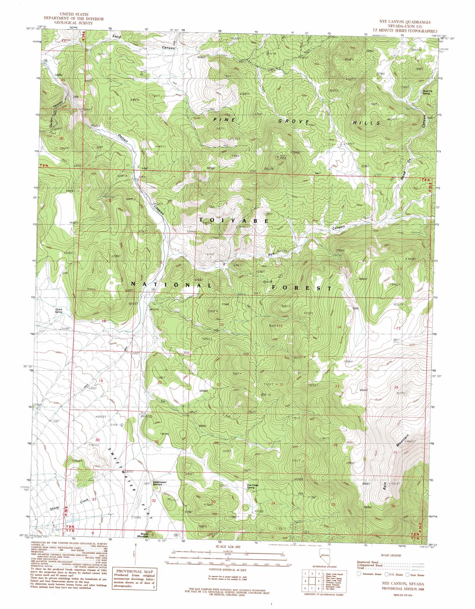
USGS Topo Quad 38119e2 - 1:24,000 scale
| Topo Map Name: | Nye Canyon |
| USGS Topo Quad ID: | 38119e2 |
| Print Size: | ca. 21 1/4" wide x 27" high |
| Southeast Coordinates: | 38.5° N latitude / 119.125° W longitude |
| Map Center Coordinates: | 38.5625° N latitude / 119.1875° W longitude |
| U.S. State: | NV |
| Filename: | o38119e2.jpg |
| Download Map JPG Image: | Nye Canyon topo map 1:24,000 scale |
| Map Type: | Topographic |
| Topo Series: | 7.5´ |
| Map Scale: | 1:24,000 |
| Source of Map Images: | United States Geological Survey (USGS) |
| Alternate Map Versions: |
Nye Canyon NV 1988, updated 1989 Download PDF Buy paper map Nye Canyon NV 2012 Download PDF Buy paper map Nye Canyon NV 2014 Download PDF Buy paper map |
| FStopo: | US Forest Service topo Nye Canyon is available: Download FStopo PDF Download FStopo TIF |
1:24,000 Topo Quads surrounding Nye Canyon
Oreana Peak |
Smith |
Wilson Canyon |
Yerington Se |
Buck Brush Spring |
Long Dry Canyon |
Desert Creek Ranch |
Mount Etna |
Pine Grove Spring |
Butler Mountain |
Risue Canyon |
Desert Creek Peak |
Nye Canyon |
Wichman Canyon |
Mitchell Spring |
Chris Flat |
Mount Patterson |
Sweetwater Creek |
The Elbow |
Ninemile Ranch |
Fales Hot Springs |
Mount Jackson |
Bridgeport |
Dome Hill |
Aurora |
> Back to 38119e1 at 1:100,000 scale
> Back to 38118a1 at 1:250,000 scale
> Back to U.S. Topo Maps home
Nye Canyon topo map: Gazetteer
Nye Canyon: Canals
Wiley Ditch elevation 2117m 6945′Nye Canyon: Gaps
Sweetwater Summit elevation 2078m 6817′Nye Canyon: Mines
Big Crystal Mine elevation 1983m 6505′Nye Canyon: Springs
Dead Ox Spring elevation 2349m 7706′Garden Canyon Spring elevation 1801m 5908′
Gulch Spring elevation 2031m 6663′
Rye Grass Spring elevation 2119m 6952′
Sand Canyon Spring elevation 2095m 6873′
Nye Canyon: Streams
Sheep Creek elevation 2100m 6889′Nye Canyon: Valleys
Dead Ox Canyon elevation 2377m 7798′Garden Canyon elevation 1946m 6384′
Nye Canyon elevation 1939m 6361′
Sand Canyon elevation 1814m 5951′
Nye Canyon digital topo map on disk
Buy this Nye Canyon topo map showing relief, roads, GPS coordinates and other geographical features, as a high-resolution digital map file on DVD: