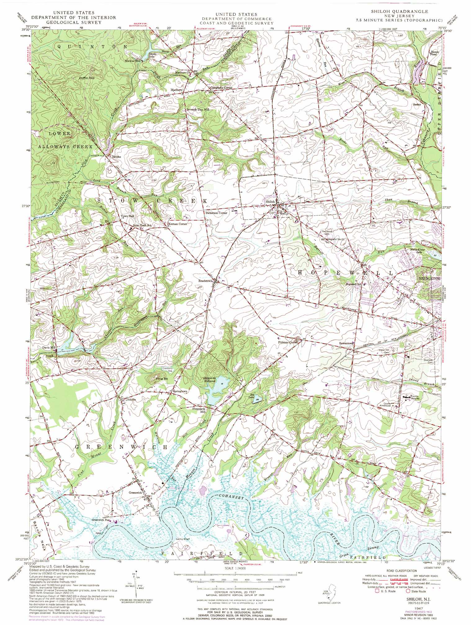
Shiloh Topo Map New Jersey
To zoom in, hover over the map of Shiloh
USGS Topo Quad 39075d3 - 1:24,000 scale
| Topo Map Name: | Shiloh |
| USGS Topo Quad ID: | 39075d3 |
| Print Size: | ca. 21 1/4" wide x 27" high |
| Southeast Coordinates: | 39.375° N latitude / 75.25° W longitude |
| Map Center Coordinates: | 39.4375° N latitude / 75.3125° W longitude |
| U.S. State: | NJ |
| Filename: | o39075d3.jpg |
| Download Map JPG Image: | Shiloh topo map 1:24,000 scale |
| Map Type: | Topographic |
| Topo Series: | 7.5´ |
| Map Scale: | 1:24,000 |
| Source of Map Images: | United States Geological Survey (USGS) |
| Alternate Map Versions: |
Shiloh NJ 1947, updated 1964 Download PDF Buy paper map Shiloh NJ 1947, updated 1969 Download PDF Buy paper map Shiloh NJ 1947, updated 1972 Download PDF Buy paper map Shiloh NJ 1947, updated 1985 Download PDF Buy paper map Shiloh NJ 1947, updated 1993 Download PDF Buy paper map Shiloh NJ 1949 Download PDF Buy paper map Shiloh NJ 2011 Download PDF Buy paper map Shiloh NJ 2014 Download PDF Buy paper map Shiloh NJ 2016 Download PDF Buy paper map |
1:24,000 Topo Quads surrounding Shiloh
Wilmington South |
Penns Grove |
Woodstown |
Pitman West |
Pitman East |
Delaware City |
Salem |
Alloway |
Elmer |
Newfield |
Taylors Bridge |
Canton |
Shiloh |
Bridgeton |
Millville |
Smyrna |
Bombay Hook |
Ben Davis Point |
Cedarville |
Dividing Creek |
Dover |
Little Creek |
Fortescue |
Port Norris |
> Back to 39075a1 at 1:100,000 scale
> Back to 39074a1 at 1:250,000 scale
> Back to U.S. Topo Maps home
Shiloh topo map: Gazetteer
Shiloh: Airports
B J Farms Airport elevation 25m 82′Oakland Farms elevation 32m 104′
Wide Sky Airpark elevation 32m 104′
Shiloh: Dams
Davis Millpond Dam elevation 3m 9′Elk Lake Dam elevation 8m 26′
Jericho Pond Dam elevation 4m 13′
Mickles Mill Dam elevation 12m 39′
Sheppards Millpond Dam elevation 3m 9′
Shiloh: Populated Places
Bowentown elevation 25m 82′Campbells Corner elevation 34m 111′
Davis Mill elevation 6m 19′
Dickerson Corner elevation 34m 111′
Fithians Corner elevation 29m 95′
Greenwich elevation 3m 9′
Harmony elevation 36m 118′
Jericho elevation 9m 29′
Kernan Corner elevation 37m 121′
Marlboro elevation 22m 72′
Mickles Mill elevation 18m 59′
Othello elevation 6m 19′
Roadstown elevation 33m 108′
Schepps Valley elevation 14m 45′
Seeley elevation 21m 68′
Sheppards Mill elevation 6m 19′
Shiloh elevation 34m 111′
Springtown elevation 11m 36′
Shiloh: Reservoirs
Davis Millpond elevation 5m 16′Elk Lake elevation 8m 26′
Hands Pond elevation 16m 52′
Jericho Pond elevation 4m 13′
Larkspur Lake elevation 3m 9′
Rhodo Lake elevation 12m 39′
Seeley Pond elevation 12m 39′
Sheppards Millpond elevation 3m 9′
Shiloh: Streams
Barrett Run elevation 10m 32′Beebe Run elevation 8m 26′
Bishop Run elevation 2m 6′
Browns Run elevation 0m 0′
Chestnut Run elevation 5m 16′
Harrow Run elevation 13m 42′
Harrow Run elevation 23m 75′
Horse Run elevation 13m 42′
Long Branch Run elevation 2m 6′
Macanippuck Run elevation 9m 29′
Mill Creek elevation 3m 9′
Mounce Creek elevation 1m 3′
Parsonage Run elevation 10m 32′
Pine Mount Creek elevation 2m 6′
Sarah Run elevation 10m 32′
West Branch Cohansey River elevation 12m 39′
Wheaton Run elevation 2m 6′
Shiloh: Summits
Coffin Hill elevation 31m 101′Pine Mount elevation 28m 91′
Shiloh: Swamps
Green Swamp elevation 0m 0′Shiloh digital topo map on disk
Buy this Shiloh topo map showing relief, roads, GPS coordinates and other geographical features, as a high-resolution digital map file on DVD:
Atlantic Coast (NY, NJ, PA, DE, MD, VA, NC)
Buy digital topo maps: Atlantic Coast (NY, NJ, PA, DE, MD, VA, NC)
 map DVD")