Alloway Topo Map New Jersey
To zoom in, hover over the map of Alloway
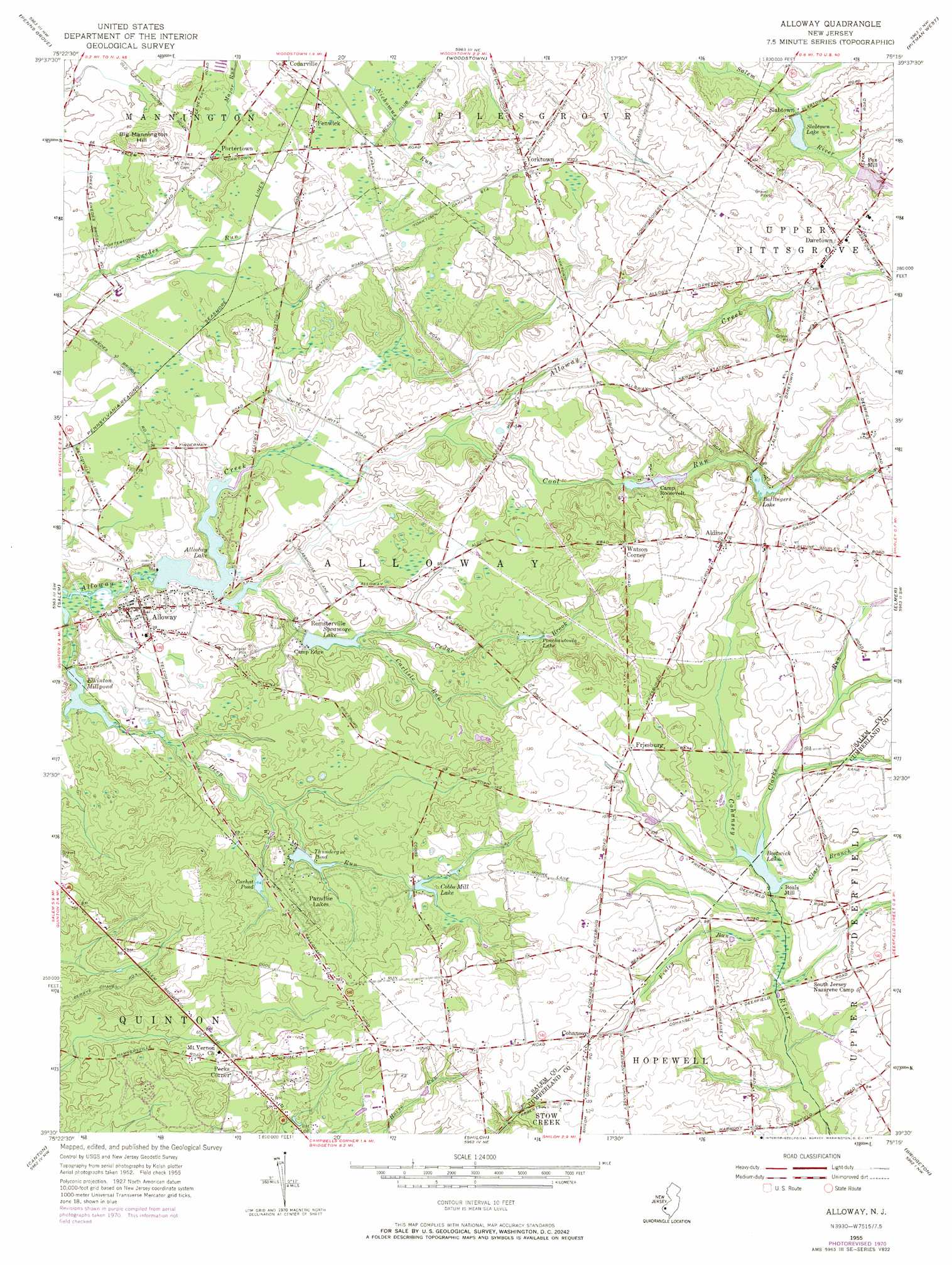
USGS Topo Quad 39075e3 - 1:24,000 scale
| Topo Map Name: | Alloway |
| USGS Topo Quad ID: | 39075e3 |
| Print Size: | ca. 21 1/4" wide x 27" high |
| Southeast Coordinates: | 39.5° N latitude / 75.25° W longitude |
| Map Center Coordinates: | 39.5625° N latitude / 75.3125° W longitude |
| U.S. State: | NJ |
| Filename: | o39075e3.jpg |
| Download Map JPG Image: | Alloway topo map 1:24,000 scale |
| Map Type: | Topographic |
| Topo Series: | 7.5´ |
| Map Scale: | 1:24,000 |
| Source of Map Images: | United States Geological Survey (USGS) |
| Alternate Map Versions: |
Alloway NJ 1955, updated 1956 Download PDF Buy paper map Alloway NJ 1955, updated 1968 Download PDF Buy paper map Alloway NJ 1955, updated 1971 Download PDF Buy paper map Alloway NJ 2011 Download PDF Buy paper map Alloway NJ 2014 Download PDF Buy paper map Alloway NJ 2016 Download PDF Buy paper map |
1:24,000 Topo Quads surrounding Alloway
Wilmington North |
Marcus Hook |
Bridgeport |
Woodbury |
Runnemede |
Wilmington South |
Penns Grove |
Woodstown |
Pitman West |
Pitman East |
Delaware City |
Salem |
Alloway |
Elmer |
Newfield |
Taylors Bridge |
Canton |
Shiloh |
Bridgeton |
Millville |
Smyrna |
Bombay Hook |
Ben Davis Point |
Cedarville |
Dividing Creek |
> Back to 39075e1 at 1:100,000 scale
> Back to 39074a1 at 1:250,000 scale
> Back to U.S. Topo Maps home
Alloway topo map: Gazetteer
Alloway: Airports
Alloway Airfield elevation 41m 134′Alloway: Dams
Alloway Lake Dam elevation 2m 6′Ballingers Mill Pond Dam elevation 24m 78′
Bostwicks Pond Dam elevation 21m 68′
Cobbs Mill Dam elevation 18m 59′
Coxhat Pond Dam elevation 18m 59′
Daretown Lake Dam elevation 24m 78′
Thundergut Pond Dam elevation 12m 39′
Wentzell-Wilson Dam elevation 34m 111′
Alloway: Lakes
Elkinton Millpond elevation 3m 9′Houses Pond elevation 6m 19′
Alloway: Populated Places
Aldine elevation 39m 127′Alloway elevation 12m 39′
Alloway Junction elevation 8m 26′
Ballingers Mill elevation 25m 82′
Beals Mill elevation 23m 75′
Cedarville elevation 18m 59′
Cobbs Mill elevation 15m 49′
Cohansey elevation 33m 108′
Daretown elevation 40m 131′
Fenwick elevation 20m 65′
Foxs Mill elevation 31m 101′
Friesburg elevation 33m 108′
Mowers elevation 9m 29′
Oakland elevation 17m 55′
Paradise Lakes elevation 28m 91′
Paulding elevation 42m 137′
Pecks Corner elevation 31m 101′
Portertown elevation 22m 72′
Remsterville elevation 11m 36′
Riddleton elevation 13m 42′
Slabtown elevation 27m 88′
Stockington elevation 16m 52′
Watson Corner elevation 42m 137′
Watsons Corner elevation 31m 101′
Woods Mills elevation 34m 111′
Yorktown elevation 33m 108′
Alloway: Reservoirs
Alloway Lake elevation 2m 6′Ballingers Lake elevation 24m 78′
Bostwick Lake elevation 21m 68′
Cobbs Mill Lake elevation 18m 59′
Coxhat Pond elevation 18m 59′
Daretown Lake elevation 24m 78′
Ponchantoula Lake elevation 18m 59′
Slabtown Lake elevation 21m 68′
Sycamore Lake elevation 8m 26′
Thundergut Pond elevation 12m 39′
Watsons Mill Pond elevation 19m 62′
Wentzell-Wilson Pond elevation 34m 111′
Alloway: Streams
Carlisle Run elevation 9m 29′Cedar Brook elevation 3m 9′
Clark Branch elevation 22m 72′
Clarks Run elevation 21m 68′
Cool Run elevation 10m 32′
Deep Run elevation 3m 9′
Finley Run elevation 21m 68′
Alloway: Summits
Big Mannington Hill elevation 36m 118′Alloway digital topo map on disk
Buy this Alloway topo map showing relief, roads, GPS coordinates and other geographical features, as a high-resolution digital map file on DVD:
Atlantic Coast (NY, NJ, PA, DE, MD, VA, NC)
Buy digital topo maps: Atlantic Coast (NY, NJ, PA, DE, MD, VA, NC)
 map DVD")