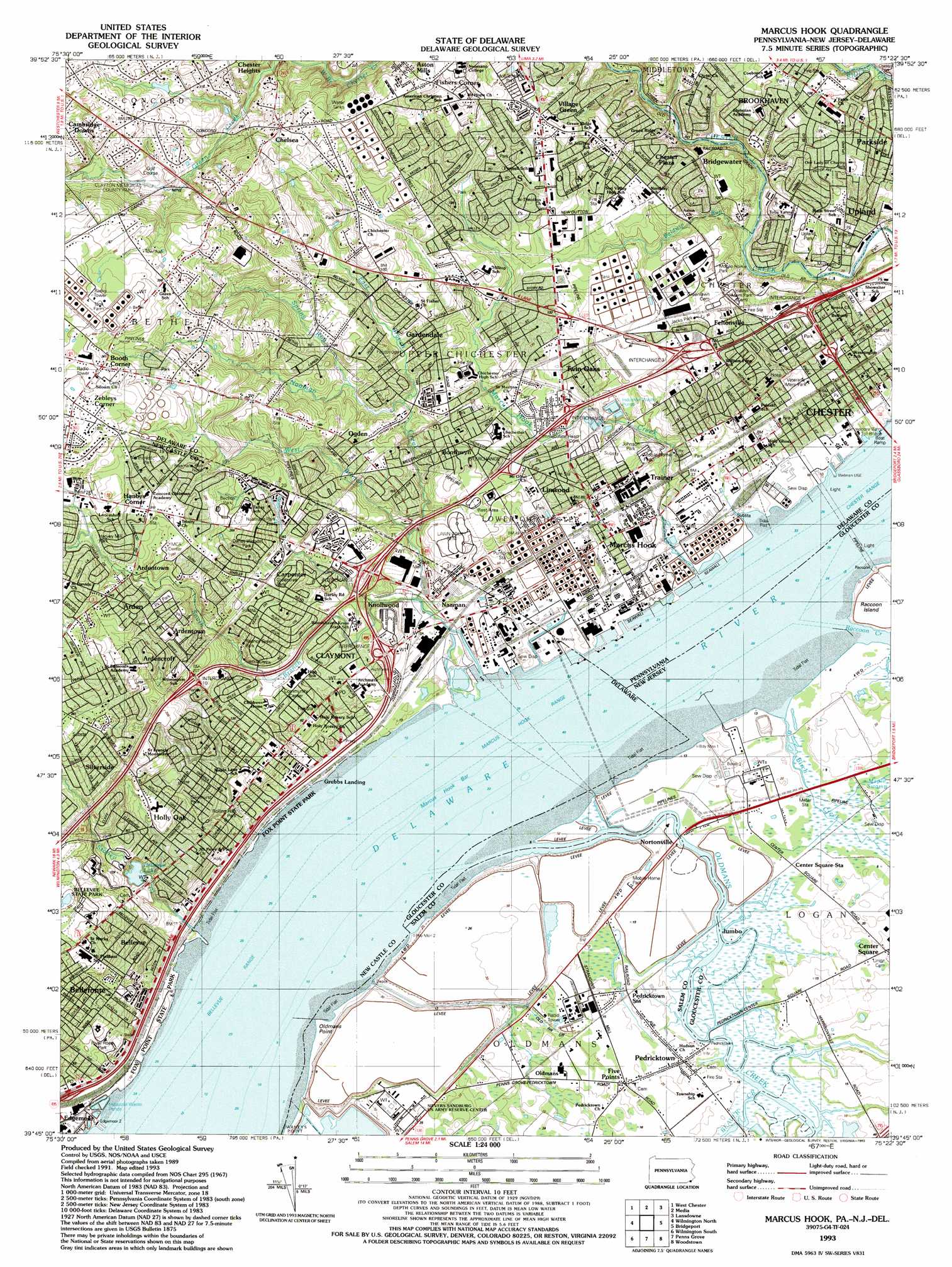
Marcus Hook Topo Map Pennsylvania
To zoom in, hover over the map of Marcus Hook
USGS Topo Quad 39075g4 - 1:24,000 scale
| Topo Map Name: | Marcus Hook |
| USGS Topo Quad ID: | 39075g4 |
| Print Size: | ca. 21 1/4" wide x 27" high |
| Southeast Coordinates: | 39.75° N latitude / 75.375° W longitude |
| Map Center Coordinates: | 39.8125° N latitude / 75.4375° W longitude |
| U.S. States: | PA, NJ, DE |
| Filename: | o39075g4.jpg |
| Download Map JPG Image: | Marcus Hook topo map 1:24,000 scale |
| Map Type: | Topographic |
| Topo Series: | 7.5´ |
| Map Scale: | 1:24,000 |
| Source of Map Images: | United States Geological Survey (USGS) |
| Alternate Map Versions: |
Marcus Hook PA 1953, updated 1956 Download PDF Buy paper map Marcus Hook PA 1953, updated 1964 Download PDF Buy paper map Marcus Hook PA 1967, updated 1970 Download PDF Buy paper map Marcus Hook PA 1967, updated 1987 Download PDF Buy paper map Marcus Hook PA 1967, updated 1991 Download PDF Buy paper map Marcus Hook PA 1993, updated 1993 Download PDF Buy paper map Marcus Hook PA 1993, updated 1993 Download PDF Buy paper map Marcus Hook PA 1995, updated 2000 Download PDF Buy paper map Marcus Hook PA 2011 Download PDF Buy paper map Marcus Hook PA 2013 Download PDF Buy paper map Marcus Hook PA 2016 Download PDF Buy paper map |
1:24,000 Topo Quads surrounding Marcus Hook
Downingtown |
Malvern |
Valley Forge |
Norristown |
Germantown |
Unionville |
West Chester |
Media |
Lansdowne |
Philadelphia |
Kennett Square |
Wilmington North |
Marcus Hook |
Bridgeport |
Woodbury |
Newark East |
Wilmington South |
Penns Grove |
Woodstown |
Pitman West |
Saint Georges |
Delaware City |
Salem |
Alloway |
Elmer |
> Back to 39075e1 at 1:100,000 scale
> Back to 39074a1 at 1:250,000 scale
> Back to U.S. Topo Maps home
Marcus Hook topo map: Gazetteer
Marcus Hook: Areas
Chichester Rest Area elevation 31m 101′The Bought (historical) elevation 9m 29′
Marcus Hook: Bars
Marcus Hook Bar elevation 0m 0′Marcus Hook: Bridges
Naamans Bridge elevation 10m 32′Marcus Hook: Capes
Oldmans Point elevation 2m 6′Marcus Hook: Channels
Bellevue Range elevation 0m 0′Marcus Hook Range elevation 0m 0′
Marcus Hook: Crossings
Interchange 1 elevation 22m 72′Interchange 10 elevation 56m 183′
Interchange 11 elevation 22m 72′
Interchange 2 elevation 25m 82′
Interchange 3A elevation 30m 98′
Interchange 3B elevation 26m 85′
Interchange 4 elevation 27m 88′
Interchange 5 elevation 17m 55′
Marcus Hook: Dams
Bellevue Lake Dam elevation 25m 82′Llewellen Mill Dam elevation 53m 173′
Marcus Hook: Guts
Birch Creek elevation 2m 6′Marcus Hook: Parks
Bellevue State Park elevation 58m 190′Betchtel Park elevation 83m 272′
Caleb Pusey Historic Site elevation 5m 16′
Camp Upland Park elevation 24m 78′
Crozier Park elevation 3m 9′
Knollwood Park elevation 11m 36′
Naamans North Park elevation 80m 262′
Nelson D Clayton Memorial Park elevation 70m 229′
Veterans Memorial Park elevation 12m 39′
Worrilow Park elevation 12m 39′
Marcus Hook: Populated Places
Addick Estates elevation 11m 36′Afton elevation 88m 288′
Analine Village elevation 21m 68′
Aniline Village elevation 20m 65′
Arden elevation 78m 255′
Ardencroft elevation 87m 285′
Ardentown elevation 72m 236′
Ashbourne Hills elevation 50m 164′
Aston Arms elevation 63m 206′
Aston Mills elevation 73m 239′
Ballymeade elevation 97m 318′
Bellevue elevation 4m 13′
Bellevue Hills elevation 41m 134′
Beverly Woods elevation 86m 282′
Bigger Tract elevation 31m 101′
Booths Corner elevation 119m 390′
Boothwyn elevation 30m 98′
Brandywine Estates elevation 34m 111′
Bridgewater elevation 12m 39′
Brookhaven elevation 30m 98′
Brookview elevation 30m 98′
Buckingham Heights elevation 97m 318′
Carpenter elevation 48m 157′
Cavagrado elevation 90m 295′
Cedartree elevation 97m 318′
Chelsea elevation 91m 298′
Chester Plaza elevation 32m 104′
Clair Manor elevation 101m 331′
Claymont elevation 22m 72′
Claymont Addition elevation 33m 108′
Claymont Heights elevation 33m 108′
Claymont Manor elevation 15m 49′
Claymont Terrace elevation 31m 101′
Claymont Village elevation 15m 49′
Cragmere elevation 37m 121′
Cragmere Woods elevation 11m 36′
Creekside Village at Naamans elevation 45m 147′
Crestfield elevation 88m 288′
Darley Woods elevation 62m 203′
Delaire elevation 24m 78′
Duponts Landing elevation 1m 3′
Edgemoor elevation 10m 32′
Edgemoor Gardens elevation 24m 78′
Feltonville elevation 28m 91′
Fisher Corners elevation 94m 308′
Five Points elevation 5m 16′
Gardendale elevation 36m 118′
Garnet Oaks elevation 92m 301′
Garnet Valley elevation 20m 65′
Glen Estates elevation 39m 127′
Goodley Manor elevation 89m 291′
Green Acres elevation 70m 229′
Green Ridge elevation 47m 154′
Greenbrooke elevation 85m 278′
Greenmount elevation 12m 39′
Greenshire elevation 33m 108′
Greentree elevation 38m 124′
Grubbs Corner elevation 101m 331′
Grubbs Corner elevation 78m 255′
Grubbs Landing elevation 3m 9′
Gwinhurst elevation 30m 98′
Hanbys Corner elevation 94m 308′
Hiddencreek elevation 66m 216′
Highland Woods elevation 86m 282′
Hillendale elevation 61m 200′
Hilltop Manor elevation 27m 88′
Holly Hills elevation 62m 203′
Holly Oak elevation 25m 82′
Holly Oak Terrace elevation 36m 118′
Indian Field elevation 66m 216′
Jumbo elevation 3m 9′
Kings Ridge elevation 98m 321′
KynLyn Apartments elevation 28m 91′
Lancashire elevation 93m 305′
Lennox Park Mobile Home Park elevation 25m 82′
Lindamere elevation 28m 91′
Linwood elevation 31m 101′
Log Run elevation 89m 291′
Longview Farms elevation 71m 232′
Maplechase elevation 101m 331′
Marcus Hook elevation 9m 29′
Morgan elevation 62m 203′
Munsee elevation 90m 295′
Naaman elevation 13m 42′
Northcrest elevation 113m 370′
Northhurst elevation 7m 22′
Nortonville elevation 3m 9′
Ogden elevation 37m 121′
Oldmans elevation 3m 9′
Overlook Colony elevation 30m 98′
Parkridge at Bellevue elevation 9m 29′
Parkside elevation 29m 95′
Pedricktown elevation 3m 9′
Penrock elevation 47m 154′
Princeton Estates elevation 42m 137′
Quarryville elevation 18m 59′
Radnor Green elevation 43m 141′
Ramble Woods elevation 67m 219′
Riverside elevation 19m 62′
Riverside Addition elevation 8m 26′
Riverview Gardens elevation 43m 141′
Riviera at Concord elevation 87m 285′
Rolling Park elevation 7m 22′
Scots Glen elevation 89m 291′
Seton elevation 7m 22′
Seton Villa elevation 25m 82′
Silverside elevation 58m 190′
Silverside Heights elevation 26m 85′
South Chester elevation 12m 39′
Stockdale elevation 25m 82′
Talley Farms elevation 112m 367′
The Hills at Bethel elevation 87m 285′
The Timbers elevation 87m 285′
Trainer elevation 22m 72′
Twin Oaks elevation 33m 108′
Upland elevation 10m 32′
Valley Run elevation 60m 196′
Village Green elevation 67m 219′
Wembly elevation 58m 190′
Westerloo elevation 113m 370′
White Village elevation 34m 111′
Whites Village elevation 33m 108′
Windy Bush elevation 82m 269′
Woodacres elevation 32m 104′
Woodside Hills elevation 43m 141′
Woodstream Gardens elevation 31m 101′
Worthland elevation 25m 82′
Wycliff elevation 56m 183′
Zebleys Corner elevation 116m 380′
Marcus Hook: Post Offices
Aston Post Office elevation 55m 180′Brookhaven Post Office elevation 32m 104′
Marcus Hook Post Office elevation 9m 29′
Pedricktown Post Office elevation 5m 16′
Marcus Hook: Reservoirs
Bellevue Lake elevation 25m 82′Marcus Hook: Streams
Baldwin Run elevation 4m 13′Beaver Creek elevation 0m 0′
Dutton Run elevation 31m 101′
East Branch Naaman Creek elevation 17m 55′
Marcus Hook Creek elevation 4m 13′
Naaman Creek elevation 3m 9′
Oldmans Creek elevation 0m 0′
Perkins Run elevation 3m 9′
Raccoon Creek elevation 0m 0′
Shepard Run elevation 7m 22′
South Branch Naaman Creek elevation 9m 29′
Spring Run elevation 26m 85′
Stoney Creek elevation 1m 3′
Stoney Creek elevation 0m 0′
Trimble Run (historical) elevation 12m 39′
West Branch Naaman Creek elevation 17m 55′
Marcus Hook digital topo map on disk
Buy this Marcus Hook topo map showing relief, roads, GPS coordinates and other geographical features, as a high-resolution digital map file on DVD:
Atlantic Coast (NY, NJ, PA, DE, MD, VA, NC)
Buy digital topo maps: Atlantic Coast (NY, NJ, PA, DE, MD, VA, NC)
 map DVD")