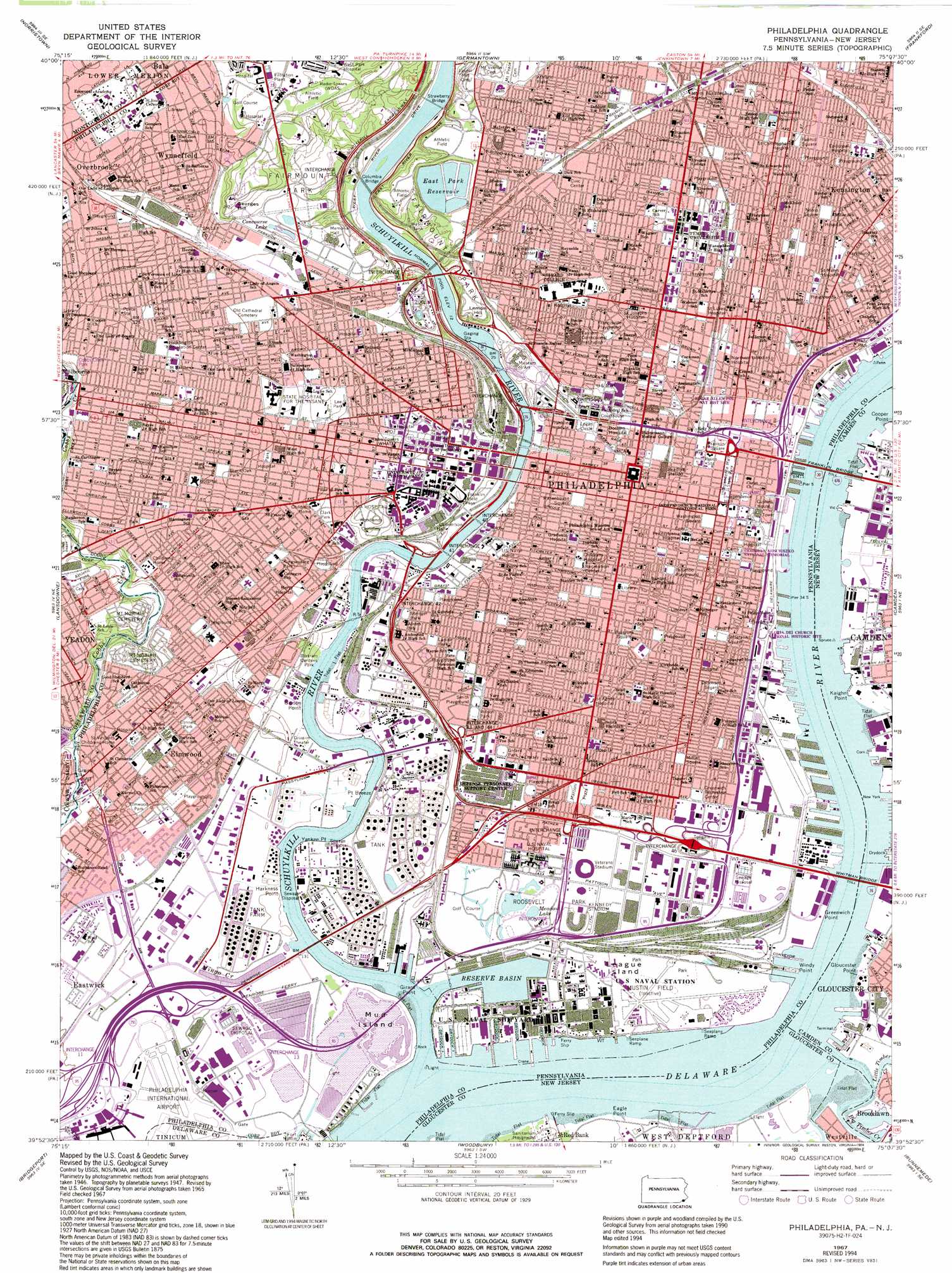
Philadelphia Topo Map Pennsylvania
To zoom in, hover over the map of Philadelphia
USGS Topo Quad 39075h2 - 1:24,000 scale
| Topo Map Name: | Philadelphia |
| USGS Topo Quad ID: | 39075h2 |
| Print Size: | ca. 21 1/4" wide x 27" high |
| Southeast Coordinates: | 39.875° N latitude / 75.125° W longitude |
| Map Center Coordinates: | 39.9375° N latitude / 75.1875° W longitude |
| U.S. States: | PA, NJ |
| Filename: | o39075h2.jpg |
| Download Map JPG Image: | Philadelphia topo map 1:24,000 scale |
| Map Type: | Topographic |
| Topo Series: | 7.5´ |
| Map Scale: | 1:24,000 |
| Source of Map Images: | United States Geological Survey (USGS) |
| Alternate Map Versions: |
Philadelphia PA 1949, updated 1953 Download PDF Buy paper map Philadelphia PA 1949, updated 1959 Download PDF Buy paper map Philadelphia PA 1967, updated 1970 Download PDF Buy paper map Philadelphia PA 1967, updated 1974 Download PDF Buy paper map Philadelphia PA 1967, updated 1985 Download PDF Buy paper map Philadelphia PA 1967, updated 1987 Download PDF Buy paper map Philadelphia PA 1967, updated 1994 Download PDF Buy paper map Philadelphia PA 1967, updated 1994 Download PDF Buy paper map Philadelphia PA 1995, updated 1999 Download PDF Buy paper map Philadelphia PA 2011 Download PDF Buy paper map Philadelphia PA 2013 Download PDF Buy paper map Philadelphia PA 2016 Download PDF Buy paper map |
1:24,000 Topo Quads surrounding Philadelphia
Collegeville |
Lansdale |
Ambler |
Hatboro |
Langhorne |
Valley Forge |
Norristown |
Germantown |
Frankford |
Beverly |
Media |
Lansdowne |
Philadelphia |
Camden |
Moorestown |
Marcus Hook |
Bridgeport |
Woodbury |
Runnemede |
Clementon |
Penns Grove |
Woodstown |
Pitman West |
Pitman East |
Williamstown |
> Back to 39075e1 at 1:100,000 scale
> Back to 39074a1 at 1:250,000 scale
> Back to U.S. Topo Maps home
Philadelphia topo map: Gazetteer
Philadelphia: Airports
Copter PNB Philadelphia Airport elevation 9m 29′Eighth and Master Streets Yard Airport elevation 7m 22′
Federal Reserve Bank Heliport elevation 7m 22′
Girard Helistop elevation 6m 19′
Penns Landing Pier 36 Heliport elevation 5m 16′
Philadelphia Fire Department Heliport elevation 27m 88′
Philadelphia Market Street Airport elevation 6m 19′
S and C 8th and Market Helistop elevation 10m 32′
S and C Distribution Center Heliport elevation 2m 6′
Seaplane Dock of Philadelphia Airport elevation 10m 32′
Stadium-Hilton Airport elevation 6m 19′
Thomas Jefferson University Hospital Heliport elevation 6m 19′
Philadelphia: Bars
Horseshoe Shoal elevation 0m 0′Philadelphia: Bays
Reserve Basin elevation 10m 32′Philadelphia: Bridges
Benjamin Franklin Bridge elevation 0m 0′Columbia Bridge elevation 3m 9′
Franklin Bridge elevation 0m 0′
Girard Avenue Bridge elevation 3m 9′
Girard Bridge elevation 3m 9′
Girard Point Bridge elevation 0m 0′
Platt Memorial Bridge elevation 0m 0′
Strawberry Bridge elevation 3m 9′
University Avenue Bridge elevation 1m 3′
Walt Whitman Bridge elevation 0m 0′
Whitman Bridge elevation 0m 0′
Philadelphia: Capes
Eagle Point elevation 0m 0′Gibson Point elevation 4m 13′
Girard Point elevation 0m 0′
Gloucester Point elevation 3m 9′
Greenwich Point elevation 6m 19′
Harkness Point elevation 1m 3′
Kaighn Point elevation 2m 6′
Point Breeze elevation 5m 16′
Windy Point elevation 6m 19′
Yankee Point elevation 5m 16′
Philadelphia: Channels
Eagle Point Range elevation 0m 0′Eagle Point Range elevation 0m 0′
Horseshoe Bend elevation 0m 0′
Horseshoe Range elevation 0m 0′
Reach M elevation 0m 0′
Philadelphia: Crossings
Interchange 13 elevation 3m 9′Interchange 14 elevation 4m 13′
Interchange 15 elevation 4m 13′
Interchange 17 elevation 6m 19′
Interchange 19 elevation 6m 19′
Interchange 20 elevation 6m 19′
Interchange 23 elevation 6m 19′
Interchange 341 elevation 23m 75′
Interchange 342 elevation 8m 26′
Interchange 343 elevation 7m 22′
Interchange 344 elevation 6m 19′
Interchange 345 elevation 4m 13′
Interchange 346A elevation 6m 19′
Interchange 346B elevation 7m 22′
Interchange 346C elevation 8m 26′
Interchange 347A elevation 12m 39′
Interchange 347B elevation 12m 39′
Interchange 348 elevation 6m 19′
Interchange 349 elevation 6m 19′
Interchange 350 elevation 6m 19′
Interchange 351 elevation 6m 19′
Philadelphia: Dams
Fairmount Dam elevation 6m 19′Pa-237 Dam elevation 0m 0′
Philadelphia: Flats
League Island elevation 6m 19′Mud Island elevation 5m 16′
Philadelphia: Islands
Greenwich Island elevation 6m 19′Province Island elevation 3m 9′
Smith Island (historical) elevation 0m 0′
Wind Mill Island (historical) elevation 0m 0′
Philadelphia: Lakes
Centennial Lake elevation 31m 101′Concourse Lake elevation 37m 121′
Meadow Lake elevation 2m 6′
Philadelphia: Parks
Angora Park elevation 26m 85′Bartram Gardens Park elevation 10m 32′
Benjamin Franklin National Memorial elevation 7m 22′
Bird Lake Picnic Area elevation 17m 55′
Black Oak Park elevation 30m 98′
Citizens Bank Park elevation 6m 19′
Clark Park elevation 16m 52′
Comegys Playground elevation 23m 75′
Connie Mack Stadium elevation 35m 114′
Dickinson Square elevation 6m 19′
Durham Park elevation 29m 95′
Edgar Allan Poe National Historic Site elevation 13m 42′
Elmwood Park elevation 13m 42′
Fairhill Square elevation 24m 78′
Fairmount Park Athletic Field elevation 33m 108′
Fotterall Square elevation 25m 82′
Francisville Playground elevation 30m 98′
Franklin Field elevation 6m 19′
Franklin Square elevation 12m 39′
Girard Park elevation 7m 22′
Gloria Dei-Old Swedes Church National Historic Site elevation 5m 16′
Greenwich Recreation Center elevation 5m 16′
Haddington Park elevation 34m 111′
Haddington Recreation Center elevation 34m 111′
Independence Mall State Park elevation 9m 29′
Independence National Historical Park elevation 7m 22′
Independence Visitor Center elevation 9m 29′
Jefferson Square elevation 7m 22′
John F Kennedy Stadium (historical) elevation 6m 19′
Kennedy Stadium elevation 6m 19′
Kingsessing Park elevation 24m 78′
Kingsessing Playground elevation 23m 75′
Lanier Park elevation 10m 32′
Lee Park elevation 26m 85′
Lincoln Financial Field elevation 6m 19′
Mifflin Square elevation 5m 16′
National Constitution Center elevation 10m 32′
Palumbo Playground elevation 9m 29′
Paschall Playground elevation 9m 29′
Passyunk Square elevation 9m 29′
Pennsylvania Treaty Park elevation 5m 16′
Philadelphia Zoological Garden elevation 13m 42′
Point Breeze Park elevation 6m 19′
Reyburn Park elevation 32m 104′
Rittenhouse Square elevation 13m 42′
Roosevelt Park elevation 7m 22′
Seger Recreation Center elevation 10m 32′
Smith Playground elevation 10m 32′
Starr Garden Park elevation 9m 29′
Starr Garden Recreation Center elevation 8m 26′
Stringer Park elevation 9m 29′
Suffolk Park elevation 5m 16′
Thaddeus Kosciuszko National Memorial elevation 7m 22′
Tiptop Playground elevation 5m 16′
Tomb of Unknown Soldier of Revolution (historical) elevation 8m 26′
Vare Playground elevation 11m 36′
Veterans Stadium (historical) elevation 5m 16′
Wachovia Center elevation 6m 19′
Wachovia Spectrum elevation 6m 19′
Washington Square elevation 9m 29′
Wharton Square elevation 11m 36′
Wilson Park elevation 10m 32′
Philadelphia: Populated Places
Angora elevation 26m 85′Bala elevation 77m 252′
Bartram Village elevation 12m 39′
Bell Road (historical) elevation 5m 16′
Bella Vista elevation 8m 26′
Belmont elevation 31m 101′
Brewerytown elevation 28m 91′
Cardington elevation 29m 95′
Carroll Park elevation 36m 118′
Carroll Park elevation 32m 104′
Cedar Park elevation 30m 98′
Chinatown elevation 12m 39′
Cobbs Creek elevation 30m 98′
Eastwick elevation 1m 3′
Elmwood elevation 7m 22′
Fairmount elevation 25m 82′
Fishtown elevation 4m 13′
Francisville elevation 31m 101′
Garden Court elevation 31m 101′
Girard Estate elevation 9m 29′
Grays Ferry elevation 11m 36′
Haddington elevation 35m 114′
Haddington elevation 26m 85′
Hartranft elevation 23m 75′
Hawthorne elevation 10m 32′
Kensington elevation 12m 39′
Kingsessing elevation 23m 75′
Ludlow elevation 10m 32′
Mantua elevation 31m 101′
Merion elevation 77m 252′
Mill Creek elevation 25m 82′
North Central elevation 30m 98′
Northern Liberties elevation 9m 29′
Old City elevation 6m 19′
Olde Kensington elevation 6m 19′
Overbrook elevation 74m 242′
Packer Park elevation 6m 19′
Parkside elevation 37m 121′
Paschall elevation 23m 75′
Passyunk Homes elevation 7m 22′
Pennsport elevation 6m 19′
Philadelphia elevation 12m 39′
Point Breeze elevation 10m 32′
Poplar elevation 14m 45′
Powelton elevation 26m 85′
Queen Village elevation 6m 19′
Rittenhouse elevation 12m 39′
Schuylkill elevation 9m 29′
Sharswood elevation 32m 104′
Society Hill elevation 7m 22′
Southwest Center City elevation 12m 39′
Southwest Schuylkill elevation 12m 39′
Spring Garden elevation 26m 85′
Spruce Hill elevation 28m 91′
Stenton elevation 28m 91′
Strawberry Mansion elevation 30m 98′
Tasker Homes elevation 11m 36′
University City elevation 6m 19′
West Kensington elevation 18m 59′
Wharton elevation 7m 22′
Whitman elevation 5m 16′
Wynnefield elevation 60m 196′
Yorktown elevation 17m 55′
Philadelphia: Post Offices
Franklin Post Office elevation 8m 26′John Wanamaker Post Office elevation 13m 42′
Kingsessing Post Office elevation 30m 98′
Middle City Post Office elevation 12m 39′
North Philadelphia West Post Office elevation 31m 101′
Overbrook Station Post Office elevation 49m 160′
Paschall Post Office elevation 8m 26′
Philadelphia Main Post Office elevation 6m 19′
Point Breeze Post Office elevation 10m 32′
Schuylkill Post Office elevation 12m 39′
Southwark Post Office elevation 8m 26′
University City Post Office elevation 25m 82′
West Market Street Post Office elevation 33m 108′
West Park Station Post Office elevation 43m 141′
William Penn Post Office elevation 11m 36′
Philadelphia: Reservoirs
East Park Reservoir elevation 43m 141′Fort Mifflin Disposal Area elevation 0m 0′
Schuylkill Rowing Basin elevation 6m 19′
Philadelphia: Streams
Big Timber Creek elevation 0m 0′Bow Creek (historical) elevation 5m 16′
Cohocksink Creek (historical) elevation 36m 118′
Georges Run (historical) elevation 66m 216′
Hollanders Creek (historical) elevation 1m 3′
Little Timber Creek elevation 0m 0′
Mingo Creek elevation 6m 19′
Mingo Creek elevation 2m 6′
Newton Creek elevation 0m 0′
Schuylkill River elevation 0m 0′
Shed Brook elevation 5m 16′
Philadelphia: Summits
Georges Hill elevation 64m 209′Lemon Hill elevation 26m 85′
Philadelphia digital topo map on disk
Buy this Philadelphia topo map showing relief, roads, GPS coordinates and other geographical features, as a high-resolution digital map file on DVD:
Atlantic Coast (NY, NJ, PA, DE, MD, VA, NC)
Buy digital topo maps: Atlantic Coast (NY, NJ, PA, DE, MD, VA, NC)
 map DVD")