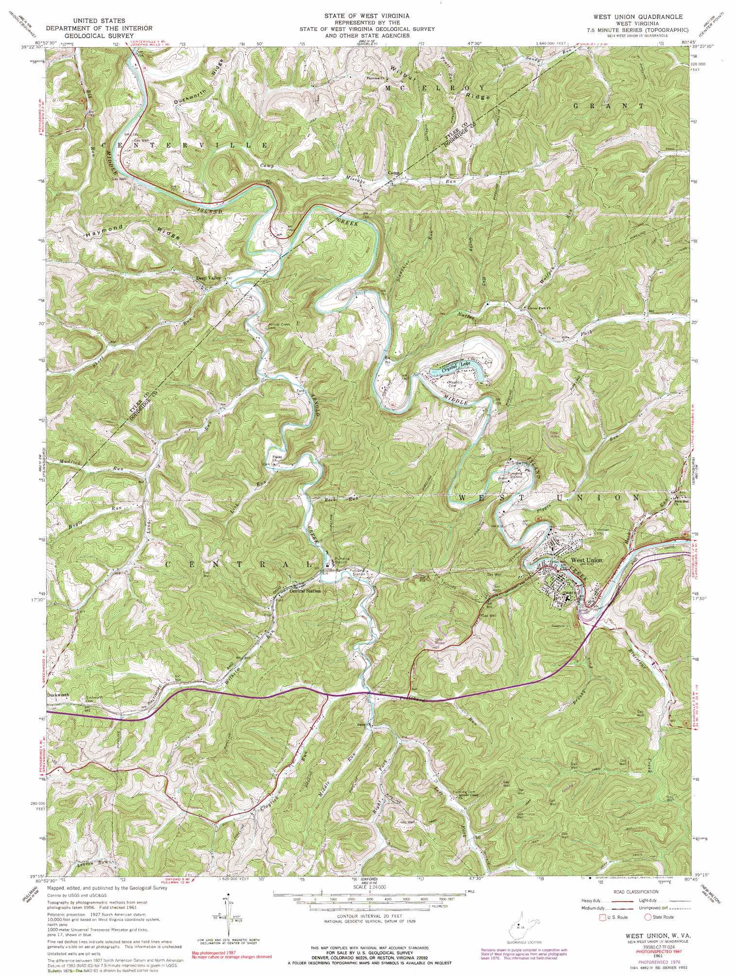
West Union Topo Map West Virginia
To zoom in, hover over the map of West Union
USGS Topo Quad 39080c7 - 1:24,000 scale
| Topo Map Name: | West Union |
| USGS Topo Quad ID: | 39080c7 |
| Print Size: | ca. 21 1/4" wide x 27" high |
| Southeast Coordinates: | 39.25° N latitude / 80.75° W longitude |
| Map Center Coordinates: | 39.3125° N latitude / 80.8125° W longitude |
| U.S. State: | WV |
| Filename: | o39080c7.jpg |
| Download Map JPG Image: | West Union topo map 1:24,000 scale |
| Map Type: | Topographic |
| Topo Series: | 7.5´ |
| Map Scale: | 1:24,000 |
| Source of Map Images: | United States Geological Survey (USGS) |
| Alternate Map Versions: |
West Union WV 1961, updated 1963 Download PDF Buy paper map West Union WV 1961, updated 1977 Download PDF Buy paper map West Union WV 1961, updated 1992 Download PDF Buy paper map West Union WV 1976, updated 1978 Download PDF Buy paper map West Union WV 2011 Download PDF Buy paper map West Union WV 2014 Download PDF Buy paper map West Union WV 2016 Download PDF Buy paper map |
1:24,000 Topo Quads surrounding West Union
New Matamoras |
Paden City |
Porters Falls |
Pine Grove |
Big Run |
Bens Run |
Middlebourne |
Shirley |
Center Point |
Folsom |
Ellenboro |
Pennsboro |
West Union |
Smithburg |
Salem |
Harrisville |
Pullman |
Oxford |
New Milton |
Big Isaac |
Smithville |
Burnt House |
Auburn |
Vadis |
Camden |
> Back to 39080a1 at 1:100,000 scale
> Back to 39080a1 at 1:250,000 scale
> Back to U.S. Topo Maps home
West Union topo map: Gazetteer
West Union: Dams
Crystal Lake Dam elevation 344m 1128′West Union: Lakes
Crystal Lake elevation 232m 761′West Union: Populated Places
Central Station elevation 244m 800′Deep Valley elevation 228m 748′
West Union elevation 240m 787′
West Union: Reservoirs
Crystal Lake elevation 344m 1128′West Union: Ridges
Duckworth Ridge elevation 301m 987′Haymond Ridge elevation 359m 1177′
Wilbur Ridge elevation 376m 1233′
West Union: Springs
Hunter Stansberry Spring elevation 237m 777′West Union: Streams
Arnold Creek elevation 222m 728′Bluestone Creek elevation 234m 767′
Brushy Fork elevation 246m 807′
Camp Mistake Run elevation 218m 715′
Claylick Run elevation 250m 820′
Gorby Run elevation 234m 767′
Hugle Run elevation 241m 790′
Left Fork Arnold Creek elevation 252m 826′
Lick Run elevation 231m 757′
Long Run elevation 226m 741′
Middle Run elevation 246m 807′
Mudlick Run elevation 239m 784′
Nutter Fork elevation 225m 738′
Piggin Run elevation 230m 754′
Pritchard Run elevation 249m 816′
Right Fork Arnold Creek elevation 252m 826′
Rock Run elevation 235m 770′
Rock Run elevation 236m 774′
Short Run elevation 222m 728′
Slaughter Run elevation 223m 731′
Wilhelm Run elevation 238m 780′
Wolfpen Run elevation 239m 784′
West Union digital topo map on disk
Buy this West Union topo map showing relief, roads, GPS coordinates and other geographical features, as a high-resolution digital map file on DVD:
 map DVD")