Parachute Topo Map Colorado
To zoom in, hover over the map of Parachute
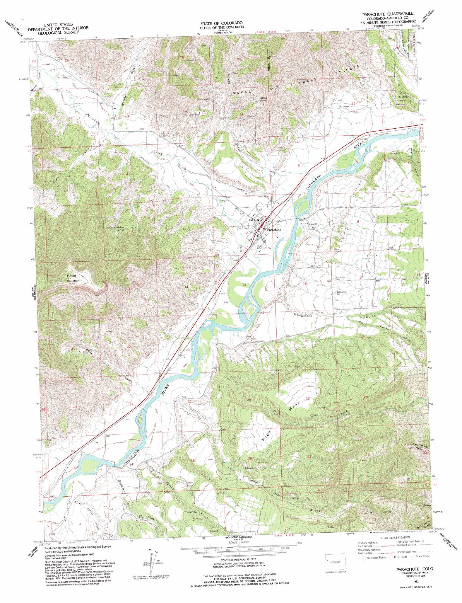
USGS Topo Quad 39108d1 - 1:24,000 scale
| Topo Map Name: | Parachute |
| USGS Topo Quad ID: | 39108d1 |
| Print Size: | ca. 21 1/4" wide x 27" high |
| Southeast Coordinates: | 39.375° N latitude / 108° W longitude |
| Map Center Coordinates: | 39.4375° N latitude / 108.0625° W longitude |
| U.S. State: | CO |
| Filename: | o39108d1.jpg |
| Download Map JPG Image: | Parachute topo map 1:24,000 scale |
| Map Type: | Topographic |
| Topo Series: | 7.5´ |
| Map Scale: | 1:24,000 |
| Source of Map Images: | United States Geological Survey (USGS) |
| Alternate Map Versions: |
Grand Valley CO 1962, updated 1964 Download PDF Buy paper map Grand Valley CO 1962, updated 1971 Download PDF Buy paper map Parachute CO 1962, updated 1992 Download PDF Buy paper map Parachute CO 2010 Download PDF Buy paper map Parachute CO 2013 Download PDF Buy paper map Parachute CO 2016 Download PDF Buy paper map |
1:24,000 Topo Quads surrounding Parachute
Bull Fork |
Cutoff Gulch |
Mccarthy Gulch |
Rio Blanco |
Horse Mountain |
Mount Blaine |
Circle Dot Gulch |
Forked Gulch |
Anvil Points |
Rifle |
Long Point |
Red Pinnacle |
Parachute |
Rulison |
North Mamm Peak |
Wagon Track Ridge |
De Beque |
Housetop Mountain |
Hawxhurst Creek |
South Mamm Peak |
Cameo |
Mesa |
Molina |
Collbran |
The Meadows |
> Back to 39108a1 at 1:100,000 scale
> Back to 39108a1 at 1:250,000 scale
> Back to U.S. Topo Maps home
Parachute topo map: Gazetteer
Parachute: Airports
Grand Valley Heliport elevation 1669m 5475′Parachute: Canals
Cornell Ditch elevation 1584m 5196′Daisy Ditch elevation 1565m 5134′
Diamond Ditch elevation 1556m 5104′
Low Cost Ditch elevation 1675m 5495′
Parachute Ditch elevation 1612m 5288′
Parachute: Populated Places
Battlement Mesa elevation 1673m 5488′Parachute elevation 1552m 5091′
Una elevation 1529m 5016′
Parachute: Springs
Mount Callahan Spring elevation 1880m 6167′Parachute: Streams
Allenwater Creek elevation 1547m 5075′Battlement Creek elevation 1555m 5101′
Dry Creek elevation 1530m 5019′
Little Alkali Creek elevation 1520m 4986′
Parachute Creek elevation 1541m 5055′
Pete and Bill Creek elevation 1528m 5013′
Spring Creek elevation 1524m 5000′
Wallace Creek elevation 1523m 4996′
Parachute: Summits
High Mesa elevation 1956m 6417′Mount Callahan elevation 2611m 8566′
Parachute: Valleys
Hayes Gulch elevation 1583m 5193′Kelly Gulch elevation 1566m 5137′
Monument Gulch elevation 1561m 5121′
Riley Gulch elevation 1637m 5370′
Starkey Gulch elevation 1656m 5433′
Stone Quarry Gulch elevation 1677m 5501′
Wheeler Gulch elevation 1647m 5403′
Parachute digital topo map on disk
Buy this Parachute topo map showing relief, roads, GPS coordinates and other geographical features, as a high-resolution digital map file on DVD: