Antelope Peak Topo Map Nevada
To zoom in, hover over the map of Antelope Peak
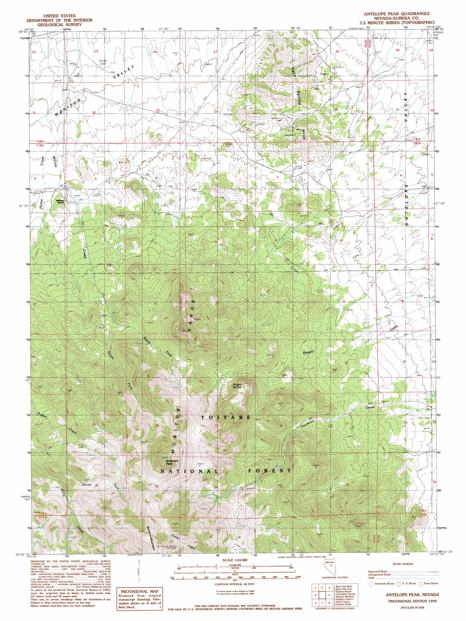
USGS Topo Quad 39116d4 - 1:24,000 scale
| Topo Map Name: | Antelope Peak |
| USGS Topo Quad ID: | 39116d4 |
| Print Size: | ca. 21 1/4" wide x 27" high |
| Southeast Coordinates: | 39.375° N latitude / 116.375° W longitude |
| Map Center Coordinates: | 39.4375° N latitude / 116.4375° W longitude |
| U.S. State: | NV |
| Filename: | o39116d4.jpg |
| Download Map JPG Image: | Antelope Peak topo map 1:24,000 scale |
| Map Type: | Topographic |
| Topo Series: | 7.5´ |
| Map Scale: | 1:24,000 |
| Source of Map Images: | United States Geological Survey (USGS) |
| Alternate Map Versions: |
Antelope Peak NV 1990, updated 1990 Download PDF Buy paper map Antelope Peak NV 2012 Download PDF Buy paper map Antelope Peak NV 2014 Download PDF Buy paper map |
| FStopo: | US Forest Service topo Antelope Peak is available: Download FStopo PDF Download FStopo TIF |
1:24,000 Topo Quads surrounding Antelope Peak
Salt Marsh Canyon |
Shagnasty |
Bartine Ranch Nw |
Bartine Ranch Ne |
West Of Whistler Mountain |
Ackerman Canyon |
Bean Flat West |
Bean Flat East |
Bartine Ranch |
Hay Ranch |
Hickison Summit |
Jackrabbit Spring |
Antelope Peak |
Antelope Meadow |
Combs Peak |
Potts Well |
Wallace Canyon |
Well Canyon |
Sullivan Wash |
West Of Bellevue Peak |
The Monitor |
White Sage Canyon |
Horse Heaven Mountain |
Ninemile Peak |
Cockalorum Spring |
> Back to 39116a1 at 1:100,000 scale
> Back to 39116a1 at 1:250,000 scale
> Back to U.S. Topo Maps home
Antelope Peak topo map: Gazetteer
Antelope Peak: Flats
Hickison Pasture elevation 2391m 7844′Antelope Peak: Springs
Dagget Spring elevation 2444m 8018′Hillside Springs (historical) elevation 2236m 7335′
Paroni Spring elevation 2012m 6601′
Antelope Peak: Streams
North Fork Kelly Creek elevation 2437m 7995′North Fork Willow Creek elevation 2227m 7306′
Pedlar Creek elevation 1927m 6322′
South Fork Willow Creek elevation 2231m 7319′
Antelope Peak: Summits
Antelope Peak elevation 3116m 10223′Summit Mountain elevation 3164m 10380′
Twin Spring Hills elevation 2107m 6912′
Antelope Peak digital topo map on disk
Buy this Antelope Peak topo map showing relief, roads, GPS coordinates and other geographical features, as a high-resolution digital map file on DVD: