Brewer Canyon Topo Map Nevada
To zoom in, hover over the map of Brewer Canyon
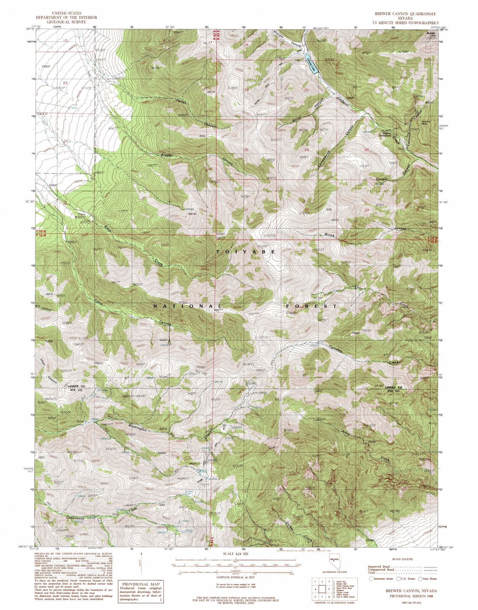
USGS Topo Quad 39117b2 - 1:24,000 scale
| Topo Map Name: | Brewer Canyon |
| USGS Topo Quad ID: | 39117b2 |
| Print Size: | ca. 21 1/4" wide x 27" high |
| Southeast Coordinates: | 39.125° N latitude / 117.125° W longitude |
| Map Center Coordinates: | 39.1875° N latitude / 117.1875° W longitude |
| U.S. State: | NV |
| Filename: | o39117b2.jpg |
| Download Map JPG Image: | Brewer Canyon topo map 1:24,000 scale |
| Map Type: | Topographic |
| Topo Series: | 7.5´ |
| Map Scale: | 1:24,000 |
| Source of Map Images: | United States Geological Survey (USGS) |
| Alternate Map Versions: |
Brewer Canyon NV 1988, updated 1988 Download PDF Buy paper map Brewer Canyon NV 2012 Download PDF Buy paper map Brewer Canyon NV 2015 Download PDF Buy paper map |
| FStopo: | US Forest Service topo Brewer Canyon is available: Download FStopo PDF Download FStopo TIF |
1:24,000 Topo Quads surrounding Brewer Canyon
Emigrant Peak |
Gandolfo Canyon |
West Of Austin |
Austin |
Simpson Park Canyon |
Iron Mountain |
Dutch Flat |
Bunker Hill |
North Toiyabe Peak |
Birch Creek Ranch |
North Shoshone Peak |
Reese River Butte |
Brewer Canyon |
Kingston |
Wildcat Peak Nw |
Barrett Canyon |
Tierney Creek |
Millett Ranch |
East Of Millett Ranch |
Wildcat Canyon |
Corral Wash |
South Toiyabe Peak |
Carvers Nw |
Carvers Ne |
Jet Spring |
> Back to 39117a1 at 1:100,000 scale
> Back to 39116a1 at 1:250,000 scale
> Back to U.S. Topo Maps home
Brewer Canyon topo map: Gazetteer
Brewer Canyon: Dams
Kingston Canyon Dam elevation 2273m 7457′Brewer Canyon: Mines
Bi-Metallic Mine elevation 2272m 7454′Brown Ledge Mine elevation 2774m 9101′
Gold Star Mine elevation 2774m 9101′
Grand View Mine elevation 2708m 8884′
Horton Mine elevation 2203m 7227′
Kingston Canyon Mine elevation 2136m 7007′
Victorine Mine elevation 2394m 7854′
Warner Mine elevation 2603m 8540′
Brewer Canyon: Populated Places
Adits Mill (historical) elevation 2349m 7706′Washington elevation 2332m 7650′
Brewer Canyon: Post Offices
Washington Post Office (historical) elevation 2329m 7641′Brewer Canyon: Reservoirs
Groves Lake elevation 2273m 7457′Brewer Canyon: Ridges
Bunker Hill elevation 3424m 11233′Brewer Canyon: Valleys
Brewer Canyon elevation 2174m 7132′Burnt Canyon elevation 2275m 7463′
Cottonwood Canyon elevation 2248m 7375′
Cougar Canyon elevation 2160m 7086′
Crane Canyon elevation 2051m 6729′
Porter Canyon elevation 1934m 6345′
Straight Canyon elevation 2269m 7444′
Victorine Canyon elevation 2154m 7066′
Brewer Canyon digital topo map on disk
Buy this Brewer Canyon topo map showing relief, roads, GPS coordinates and other geographical features, as a high-resolution digital map file on DVD: