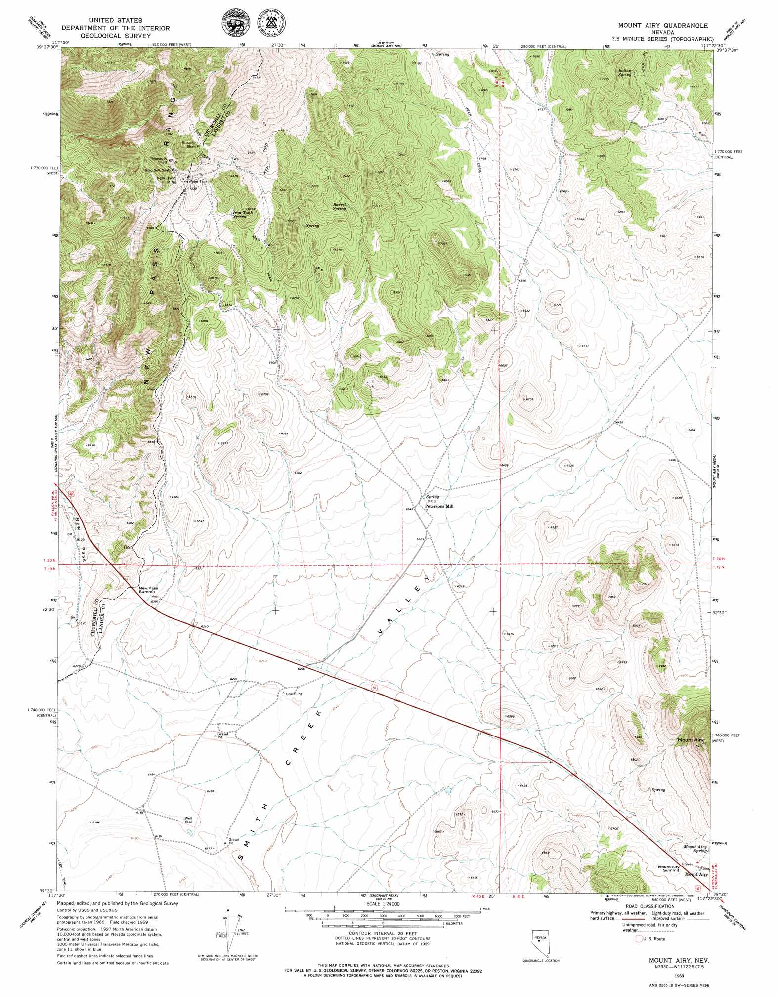
Mount Airy Topo Map Nevada
To zoom in, hover over the map of Mount Airy
USGS Topo Quad 39117e4 - 1:24,000 scale
| Topo Map Name: | Mount Airy |
| USGS Topo Quad ID: | 39117e4 |
| Print Size: | ca. 21 1/4" wide x 27" high |
| Southeast Coordinates: | 39.5° N latitude / 117.375° W longitude |
| Map Center Coordinates: | 39.5625° N latitude / 117.4375° W longitude |
| U.S. State: | NV |
| Filename: | o39117e4.jpg |
| Download Map JPG Image: | Mount Airy topo map 1:24,000 scale |
| Map Type: | Topographic |
| Topo Series: | 7.5´ |
| Map Scale: | 1:24,000 |
| Source of Map Images: | United States Geological Survey (USGS) |
| Alternate Map Versions: |
Mount Airy NV 1969, updated 1971 Download PDF Buy paper map Mount Airy NV 1969, updated 1979 Download PDF Buy paper map Mount Airy NV 2011 Download PDF Buy paper map Mount Airy NV 2014 Download PDF Buy paper map |
1:24,000 Topo Quads surrounding Mount Airy
Shoshone Meadows |
Shoshone Meadows Se |
Gilbert Creek Sw |
Gilbert Creek Se |
Manhattan Mountain |
Tungsten Mountain |
New Pass Well |
New Pass Peak |
Mount Airy Ne |
Vigus Butte Nw |
Byers Ranch |
New Pass |
Mount Airy |
Mount Airy Mesa |
Vigus Butte |
Basque Summit |
Carroll Summit Ne |
Emigrant Peak |
Gandolfo Canyon |
West Of Austin |
Carroll Summit |
Carroll Summit Se |
Iron Mountain |
Dutch Flat |
Bunker Hill |
> Back to 39117e1 at 1:100,000 scale
> Back to 39116a1 at 1:250,000 scale
> Back to U.S. Topo Maps home
Mount Airy topo map: Gazetteer
Mount Airy: Gaps
Mount Airy Summit elevation 2038m 6686′New Pass Summit elevation 1931m 6335′
Mount Airy: Mines
Gold Belt Shaft elevation 2229m 7312′Happy Days Mine elevation 2171m 7122′
Last Chance Mine elevation 2017m 6617′
Little Jumbo Mine elevation 2545m 8349′
Nevada Austin Mine elevation 2545m 8349′
New Pass Mine elevation 2180m 7152′
Rabbit Foot Mine elevation 2545m 8349′
Sheridan Mine elevation 2281m 7483′
Superoir Shaft elevation 2323m 7621′
Thomas W Shaft elevation 2253m 7391′
Yellow Bull Mine elevation 2545m 8349′
Mount Airy: Populated Places
Mount Airy elevation 2039m 6689′Newpass elevation 2183m 7162′
Petersons Mill elevation 1937m 6354′
Mount Airy: Post Offices
Newpass Post Office elevation 2183m 7162′Mount Airy: Springs
Barrel Spring elevation 2137m 7011′Indian Spring elevation 2073m 6801′
Iron Tank Spring elevation 2163m 7096′
Mount Airy Spring elevation 2067m 6781′
Petersons Mill Hot Spring elevation 1936m 6351′
Mount Airy: Summits
Mount Airy elevation 2319m 7608′Mount Airy Mesa elevation 2318m 7604′
Mount Airy digital topo map on disk
Buy this Mount Airy topo map showing relief, roads, GPS coordinates and other geographical features, as a high-resolution digital map file on DVD: