Kneecap Ridge Topo Map California
To zoom in, hover over the map of Kneecap Ridge
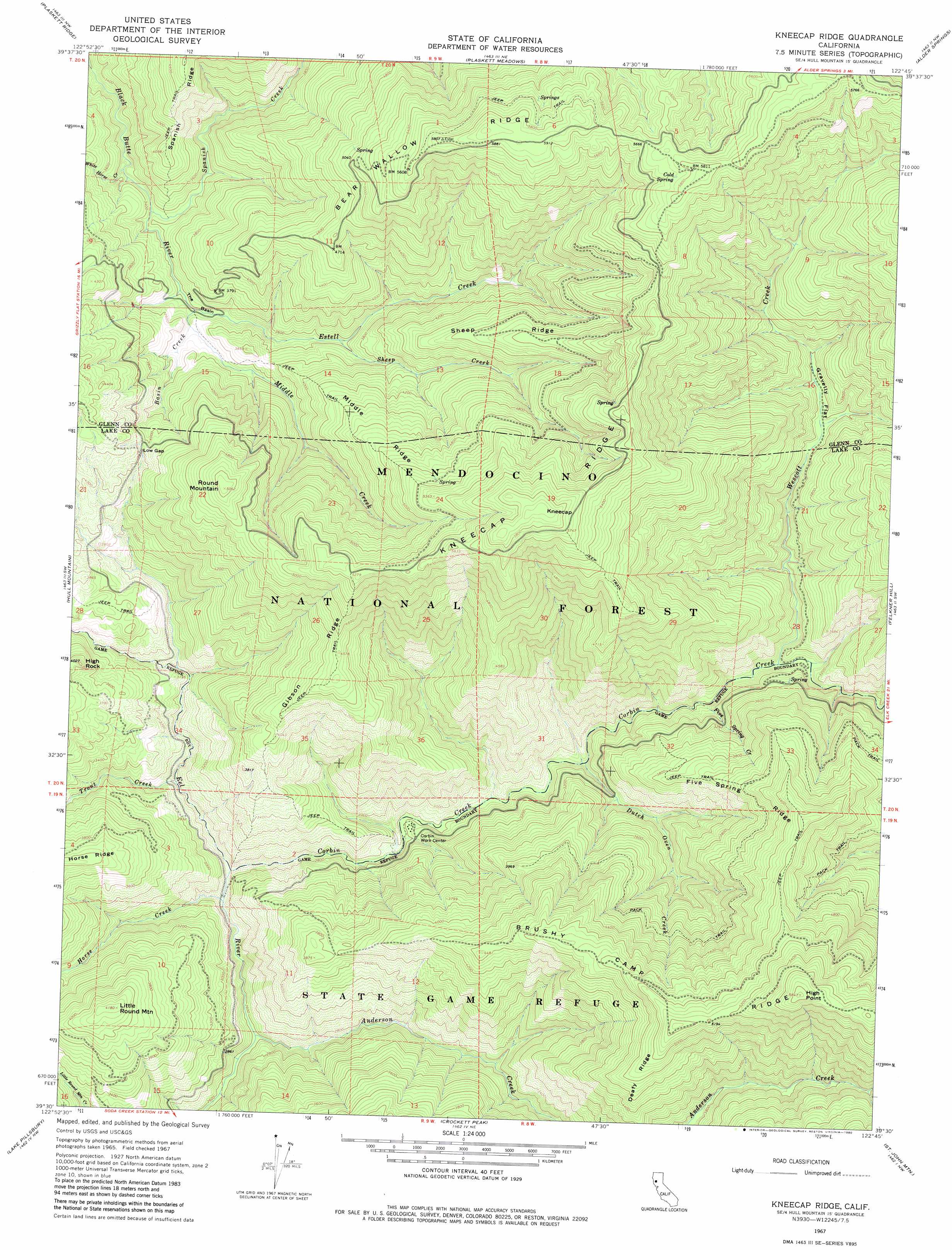
USGS Topo Quad 39122e7 - 1:24,000 scale
| Topo Map Name: | Kneecap Ridge |
| USGS Topo Quad ID: | 39122e7 |
| Print Size: | ca. 21 1/4" wide x 27" high |
| Southeast Coordinates: | 39.5° N latitude / 122.75° W longitude |
| Map Center Coordinates: | 39.5625° N latitude / 122.8125° W longitude |
| U.S. State: | CA |
| Filename: | o39122e7.jpg |
| Download Map JPG Image: | Kneecap Ridge topo map 1:24,000 scale |
| Map Type: | Topographic |
| Topo Series: | 7.5´ |
| Map Scale: | 1:24,000 |
| Source of Map Images: | United States Geological Survey (USGS) |
| Alternate Map Versions: |
Kneecap Ridge CA 1967, updated 1969 Download PDF Buy paper map Kneecap Ridge CA 1996, updated 2001 Download PDF Buy paper map Kneecap Ridge CA 2012 Download PDF Buy paper map Kneecap Ridge CA 2015 Download PDF Buy paper map |
| FStopo: | US Forest Service topo Kneecap Ridge is available: Download FStopo PDF Download FStopo TIF |
1:24,000 Topo Quads surrounding Kneecap Ridge
Newhouse Ridge |
Mendocino Pass |
Log Spring |
Hall Ridge |
Newville |
Thatcher Ridge |
Plaskett Ridge |
Plaskett Meadows |
Alder Springs |
Chrome |
Sanhedrin Mountain |
Hull Mountain |
Kneecap Ridge |
Felkner Hill |
Elk Creek |
Van Arsdale Reservoir |
Lake Pillsbury |
Crockett Peak |
Saint John Mountain |
Stonyford |
Potter Valley |
Elk Mountain |
Potato Hill |
Fouts Springs |
Gilmore Peak |
> Back to 39122e1 at 1:100,000 scale
> Back to 39122a1 at 1:250,000 scale
> Back to U.S. Topo Maps home
Kneecap Ridge topo map: Gazetteer
Kneecap Ridge: Basins
The Basin elevation 1042m 3418′Kneecap Ridge: Flats
Gravelly Flat elevation 1089m 3572′Kneecap Ridge: Forests
Mendocino National Forest elevation 1444m 4737′Kneecap Ridge: Gaps
Low Gap elevation 1230m 4035′Kneecap Ridge: Ridges
Bear Wallow Ridge elevation 1772m 5813′Brushy Camp Ridge elevation 1542m 5059′
Deafy Ridge elevation 1479m 4852′
Five Spring Ridge elevation 1263m 4143′
Gibson Ridge elevation 1335m 4379′
Kneecap Ridge elevation 1790m 5872′
Middle Ridge elevation 1417m 4648′
Sheep Ridge elevation 1442m 4730′
Kneecap Ridge: Springs
Cold Spring elevation 1753m 5751′Kneecap Ridge: Streams
Anderson Creek elevation 788m 2585′Basin Creek elevation 1051m 3448′
Corbin Creek elevation 809m 2654′
Dutch Oven Creek elevation 881m 2890′
Estell Creek elevation 1039m 3408′
Five Spring Creek elevation 917m 3008′
Horse Creek elevation 813m 2667′
Middle Creek elevation 1037m 3402′
Sheep Creek elevation 1086m 3562′
Spanish Creek elevation 1013m 3323′
Trout Creek elevation 848m 2782′
Wescott Creek elevation 925m 3034′
White Horse Creek elevation 1006m 3300′
Kneecap Ridge: Summits
High Point elevation 1780m 5839′High Rock elevation 1219m 3999′
Kneecap elevation 1809m 5935′
Little Round Mountain elevation 1275m 4183′
Round Mountain elevation 1544m 5065′
Kneecap Ridge digital topo map on disk
Buy this Kneecap Ridge topo map showing relief, roads, GPS coordinates and other geographical features, as a high-resolution digital map file on DVD: