Bellwood Topo Map Pennsylvania
To zoom in, hover over the map of Bellwood
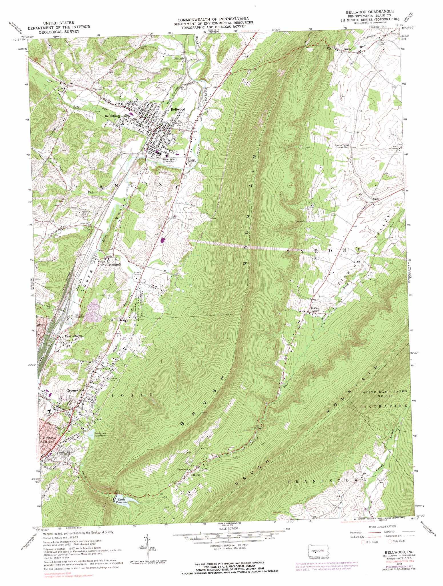
USGS Topo Quad 40078e3 - 1:24,000 scale
| Topo Map Name: | Bellwood |
| USGS Topo Quad ID: | 40078e3 |
| Print Size: | ca. 21 1/4" wide x 27" high |
| Southeast Coordinates: | 40.5° N latitude / 78.25° W longitude |
| Map Center Coordinates: | 40.5625° N latitude / 78.3125° W longitude |
| U.S. State: | PA |
| Filename: | o40078e3.jpg |
| Download Map JPG Image: | Bellwood topo map 1:24,000 scale |
| Map Type: | Topographic |
| Topo Series: | 7.5´ |
| Map Scale: | 1:24,000 |
| Source of Map Images: | United States Geological Survey (USGS) |
| Alternate Map Versions: |
Bellwood PA 1963, updated 1965 Download PDF Buy paper map Bellwood PA 1963, updated 1973 Download PDF Buy paper map Bellwood PA 1963, updated 1991 Download PDF Buy paper map Bellwood PA 1963, updated 1991 Download PDF Buy paper map Bellwood PA 2010 Download PDF Buy paper map Bellwood PA 2013 Download PDF Buy paper map Bellwood PA 2016 Download PDF Buy paper map |
1:24,000 Topo Quads surrounding Bellwood
Irvona |
Ramey |
Houtzdale |
Sandy Ridge |
Port Matilda |
Coalport |
Blandburg |
Tipton |
Tyrone |
Franklinville |
Ashville |
Altoona |
Bellwood |
Spruce Creek |
Alexandria |
Cresson |
Hollidaysburg |
Frankstown |
Williamsburg |
Huntingdon |
Blue Knob |
Roaring Spring |
Martinsburg |
Entriken |
Cassville |
> Back to 40078e1 at 1:100,000 scale
> Back to 40078a1 at 1:250,000 scale
> Back to U.S. Topo Maps home
Bellwood topo map: Gazetteer
Bellwood: Dams
Bellwood Dam elevation 475m 1558′Brush Mountain Dam elevation 523m 1715′
Pottsgrove Dam elevation 404m 1325′
Bellwood: Mines
Sinking Valley Lead Zinc Mines elevation 344m 1128′Bellwood: Parks
Blair Memorial Park elevation 317m 1040′Bellwood: Populated Places
Bellwood elevation 321m 1053′Culp elevation 319m 1046′
East Altoona elevation 346m 1135′
Elberta elevation 536m 1758′
Fostoria elevation 314m 1030′
Greenwood elevation 360m 1181′
Pinecroft elevation 324m 1062′
Reightown elevation 323m 1059′
Roots elevation 378m 1240′
Sickles Corner elevation 374m 1227′
Skelp elevation 372m 1220′
Bellwood: Reservoirs
Kettle Reservoir elevation 523m 1715′Pottsgrove Reservoir elevation 408m 1338′
Bellwood: Streams
Bells Gap Run elevation 317m 1040′Homer Gap Run elevation 329m 1079′
Riggles Gap Run elevation 323m 1059′
Sandy Run elevation 324m 1062′
Sugar Run elevation 318m 1043′
Bellwood: Summits
Brush Mountain elevation 736m 2414′Bellwood: Valleys
Logan Valley elevation 316m 1036′Bellwood digital topo map on disk
Buy this Bellwood topo map showing relief, roads, GPS coordinates and other geographical features, as a high-resolution digital map file on DVD:
 map DVD")