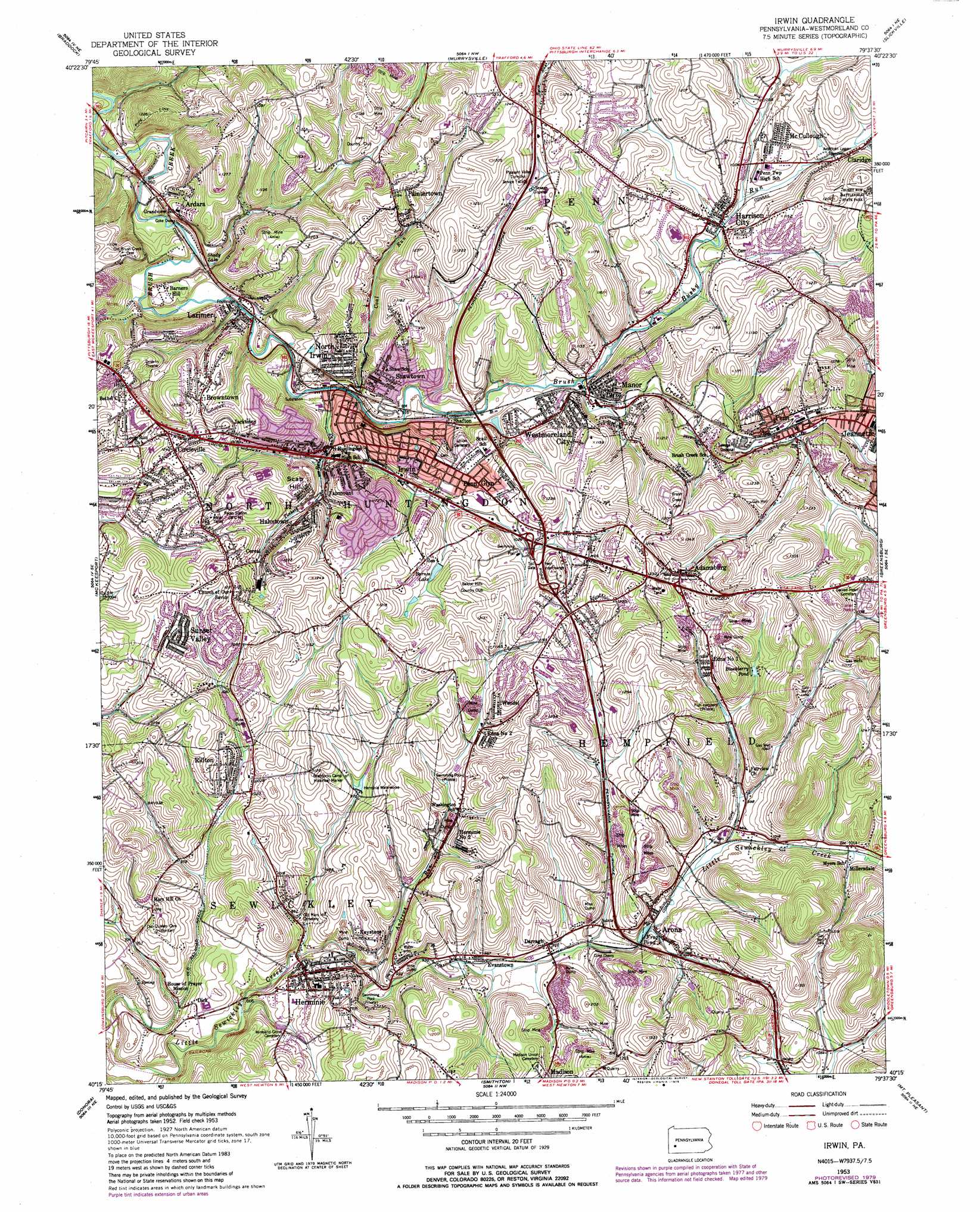
Irwin Topo Map Pennsylvania
To zoom in, hover over the map of Irwin
USGS Topo Quad 40079c6 - 1:24,000 scale
| Topo Map Name: | Irwin |
| USGS Topo Quad ID: | 40079c6 |
| Print Size: | ca. 21 1/4" wide x 27" high |
| Southeast Coordinates: | 40.25° N latitude / 79.625° W longitude |
| Map Center Coordinates: | 40.3125° N latitude / 79.6875° W longitude |
| U.S. State: | PA |
| Filename: | o40079c6.jpg |
| Download Map JPG Image: | Irwin topo map 1:24,000 scale |
| Map Type: | Topographic |
| Topo Series: | 7.5´ |
| Map Scale: | 1:24,000 |
| Source of Map Images: | United States Geological Survey (USGS) |
| Alternate Map Versions: |
Irwin PA 1953, updated 1955 Download PDF Buy paper map Irwin PA 1953, updated 1964 Download PDF Buy paper map Irwin PA 1953, updated 1970 Download PDF Buy paper map Irwin PA 1953, updated 1979 Download PDF Buy paper map Irwin PA 1953, updated 1979 Download PDF Buy paper map Irwin PA 2010 Download PDF Buy paper map Irwin PA 2013 Download PDF Buy paper map Irwin PA 2016 Download PDF Buy paper map |
1:24,000 Topo Quads surrounding Irwin
Glenshaw |
New Kensington West |
New Kensington East |
Vandergrift |
Avonmore |
Pittsburgh East |
Braddock |
Murrysville |
Slickville |
Saltsburg |
Glassport |
Mckeesport |
Irwin |
Greensburg |
Latrobe |
Monongahela |
Donora |
Smithton |
Mount Pleasant |
Mammoth |
California |
Fayette City |
Saint Clairsville |
Connellsville |
Donegal |
> Back to 40079a1 at 1:100,000 scale
> Back to 40078a1 at 1:250,000 scale
> Back to U.S. Topo Maps home
Irwin topo map: Gazetteer
Irwin: Airports
Sky Ranch Airport elevation 342m 1122′Irwin: Crossings
Interchange 67 elevation 340m 1115′Irwin: Dams
Coal Dam elevation 283m 928′Kenda Dam elevation 313m 1026′
Irwin: Parks
Braddock Camp Historical Marker elevation 314m 1030′Irwin: Populated Places
Adamsburg elevation 358m 1174′Ardara elevation 298m 977′
Arona elevation 293m 961′
Barners Hill elevation 282m 925′
Browntown elevation 350m 1148′
Cereal elevation 332m 1089′
Circleville elevation 383m 1256′
Darragh elevation 296m 971′
Dick elevation 283m 928′
Edna Number One elevation 355m 1164′
Edna Number Two elevation 322m 1056′
Evanstown elevation 295m 967′
Fairmount elevation 315m 1033′
Fulton elevation 309m 1013′
Hahntown elevation 329m 1079′
Harrison City elevation 298m 977′
Herminie elevation 298m 977′
Herminie Number 2 elevation 335m 1099′
Irwin elevation 305m 1000′
Jacktown elevation 352m 1154′
Keystone elevation 319m 1046′
Larimer elevation 267m 875′
Manor elevation 290m 951′
McCullough elevation 324m 1062′
Millersdale elevation 319m 1046′
North Irwin elevation 292m 958′
Oakville elevation 335m 1099′
Paintertown elevation 354m 1161′
Penn elevation 300m 984′
Penn Glyn elevation 325m 1066′
Rillton elevation 334m 1095′
Scab Hill elevation 330m 1082′
Shafton elevation 292m 958′
Shawtown elevation 303m 994′
Sunset Valley elevation 345m 1131′
Wendel elevation 341m 1118′
Westmoreland City elevation 303m 994′
Irwin: Post Offices
Herminie Post Office elevation 316m 1036′Irwin Post Office elevation 282m 925′
Manor Post Office elevation 304m 997′
North Huntingdon Post Office elevation 331m 1085′
Westmoreland City Post Office elevation 296m 971′
Irwin: Reservoirs
Barnes Lake elevation 319m 1046′Biddle Pond elevation 283m 928′
Blackberry Pond elevation 345m 1131′
Frog Pond elevation 298m 977′
Indian Lake elevation 313m 1026′
Shady Lake elevation 271m 889′
Irwin: Streams
Andrews Run elevation 285m 935′Bushy Run elevation 288m 944′
Coal Run elevation 282m 925′
Tinkers Run elevation 275m 902′
Irwin digital topo map on disk
Buy this Irwin topo map showing relief, roads, GPS coordinates and other geographical features, as a high-resolution digital map file on DVD:
 map DVD")