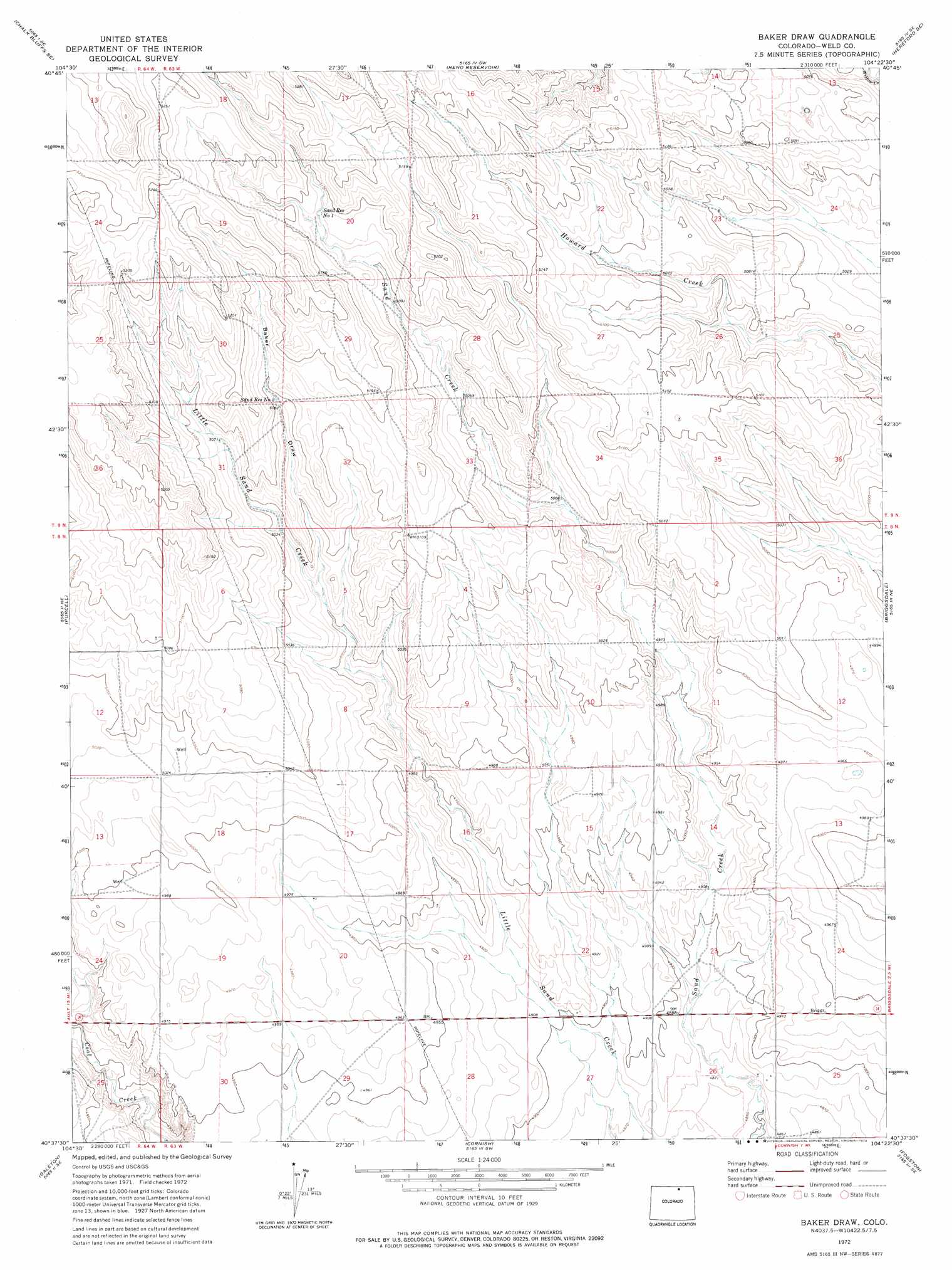
Baker Draw Topo Map Colorado
To zoom in, hover over the map of Baker Draw
USGS Topo Quad 40104f4 - 1:24,000 scale
| Topo Map Name: | Baker Draw |
| USGS Topo Quad ID: | 40104f4 |
| Print Size: | ca. 21 1/4" wide x 27" high |
| Southeast Coordinates: | 40.625° N latitude / 104.375° W longitude |
| Map Center Coordinates: | 40.6875° N latitude / 104.4375° W longitude |
| U.S. State: | CO |
| Filename: | o40104f4.jpg |
| Download Map JPG Image: | Baker Draw topo map 1:24,000 scale |
| Map Type: | Topographic |
| Topo Series: | 7.5´ |
| Map Scale: | 1:24,000 |
| Source of Map Images: | United States Geological Survey (USGS) |
| Alternate Map Versions: |
Baker Draw CO 1972, updated 1974 Download PDF Buy paper map Baker Draw CO 1997, updated 2000 Download PDF Buy paper map Baker Draw CO 2011 Download PDF Buy paper map Baker Draw CO 2013 Download PDF Buy paper map Baker Draw CO 2016 Download PDF Buy paper map |
| FStopo: | US Forest Service topo Baker Draw is available: Download FStopo PDF Download FStopo TIF |
1:24,000 Topo Quads surrounding Baker Draw
Eastman Creek North |
Squaw Rock |
Hereford Nw |
Hereford |
Grover North |
Eastman Creek South |
Eastman Creek Se |
Reno Reservoir |
Hereford Se |
Grover South |
Antelope Reservoir |
Purcell |
Baker Draw |
Briggsdale |
Keota Nw |
Eaton |
Galeton |
Cornish |
Fosston |
Dutch Girl Lake |
Greeley |
Kersey |
Barnesville |
Point Of Rocks |
Greasewood Lake |
> Back to 40104e1 at 1:100,000 scale
> Back to 40104a1 at 1:250,000 scale
> Back to U.S. Topo Maps home
Baker Draw topo map: Gazetteer
Baker Draw: Reservoirs
Howard Reservoir elevation 1523m 4996′Sand Reservoir Number 1 elevation 1564m 5131′
Sand Reservoir Number 2 elevation 1552m 5091′
Baker Draw: Valleys
Baker Draw elevation 1528m 5013′Baker Draw: Wells
Key Water Well elevation 1548m 5078′Missile West Water Well elevation 1513m 4963′
Range Rider Water Well elevation 1534m 5032′
Sorrell Water Well elevation 1536m 5039′
Baker Draw digital topo map on disk
Buy this Baker Draw topo map showing relief, roads, GPS coordinates and other geographical features, as a high-resolution digital map file on DVD: