Clear Lake Topo Map Indiana
To zoom in, hover over the map of Clear Lake
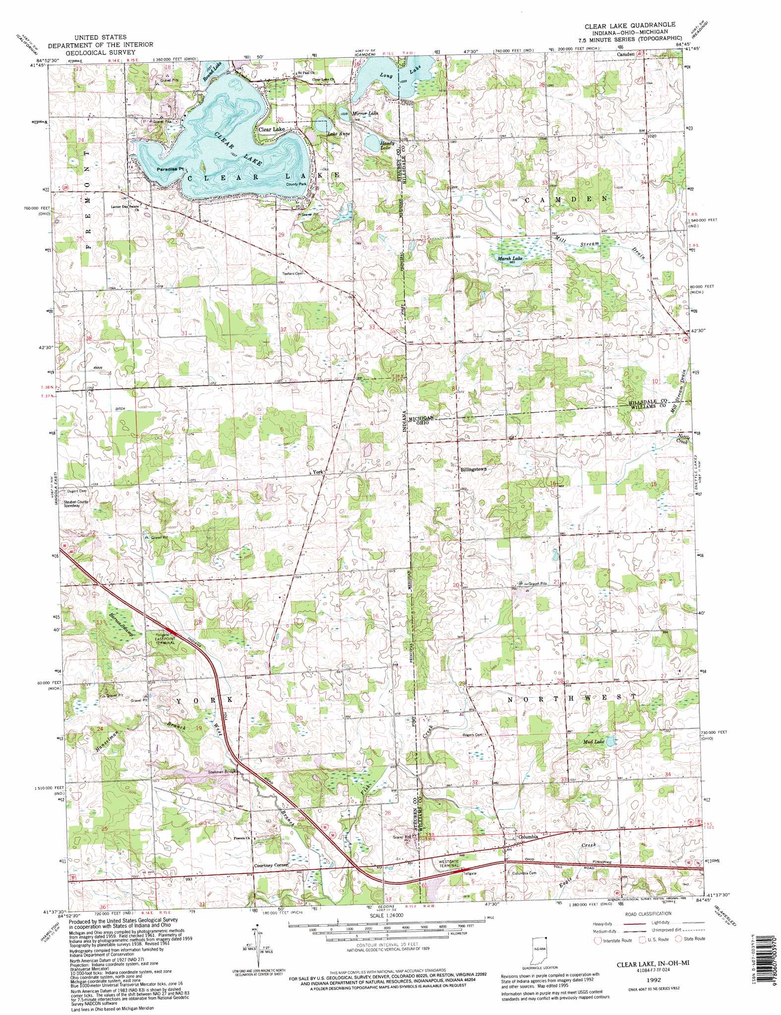
USGS Topo Quad 41084f7 - 1:24,000 scale
| Topo Map Name: | Clear Lake |
| USGS Topo Quad ID: | 41084f7 |
| Print Size: | ca. 21 1/4" wide x 27" high |
| Southeast Coordinates: | 41.625° N latitude / 84.75° W longitude |
| Map Center Coordinates: | 41.6875° N latitude / 84.8125° W longitude |
| U.S. States: | IN, OH, MI |
| Filename: | o41084f7.jpg |
| Download Map JPG Image: | Clear Lake topo map 1:24,000 scale |
| Map Type: | Topographic |
| Topo Series: | 7.5´ |
| Map Scale: | 1:24,000 |
| Source of Map Images: | United States Geological Survey (USGS) |
| Alternate Map Versions: |
Clear Lake IN 1939 Download PDF Buy paper map Clear Lake IN 1940 Download PDF Buy paper map Clear Lake IN 1961, updated 1963 Download PDF Buy paper map Clear Lake IN 1961, updated 1973 Download PDF Buy paper map Clear Lake IN 1961, updated 1990 Download PDF Buy paper map Clear Lake IN 1992, updated 1995 Download PDF Buy paper map Clear Lake IN 2011 Download PDF Buy paper map Clear Lake IN 2013 Download PDF Buy paper map Clear Lake IN 2016 Download PDF Buy paper map |
1:24,000 Topo Quads surrounding Clear Lake
Coldwater West |
Coldwater East |
Allen |
Hillsdale |
North Adams |
Kinderhook |
California |
Camden |
Reading |
Frontier |
Angola West |
Angola East |
Clear Lake |
Nettle Lake |
Pioneer |
Ashley |
Hamilton |
Edon |
Blakeslee |
Montpelier |
Waterloo |
Butler West |
Butler East |
Edgerton |
Bryan |
> Back to 41084e1 at 1:100,000 scale
> Back to 41084a1 at 1:250,000 scale
> Back to U.S. Topo Maps home
Clear Lake topo map: Gazetteer
Clear Lake: Bridges
Stallman Bridge elevation 291m 954′Clear Lake: Canals
Mill Stream Drain elevation 295m 967′Clear Lake: Capes
Paradise Point elevation 317m 1040′Clear Lake: Lakes
Clear Lake elevation 317m 1040′Handy Lake elevation 312m 1023′
Lake Anne elevation 315m 1033′
Long Lake elevation 315m 1033′
Long Lake elevation 316m 1036′
Marsh Lake elevation 299m 980′
Mirror Lake elevation 316m 1036′
Mud Lake elevation 297m 974′
Clear Lake: Parks
Mud Lake Bog Nature Preserve elevation 297m 974′Clear Lake: Populated Places
Billingstown elevation 316m 1036′Clear Lake elevation 319m 1046′
Columbia elevation 300m 984′
Courtney Corner elevation 297m 974′
Eastpoint Terminal elevation 305m 1000′
Page elevation 323m 1059′
York elevation 324m 1062′
Clear Lake: Post Offices
Clear Lake Post Office (historical) elevation 319m 1046′South Camden Post Office (historical) elevation 305m 1000′
Clear Lake: Streams
Hanselman Branch elevation 294m 964′Mill Stream Drain elevation 294m 964′
West Branch Fish Creek elevation 286m 938′
Clear Lake: Swamps
Barnes Swamp elevation 306m 1003′Clear Lake digital topo map on disk
Buy this Clear Lake topo map showing relief, roads, GPS coordinates and other geographical features, as a high-resolution digital map file on DVD:
Northern Illinois, Northern Indiana & Southwestern Michigan
Buy digital topo maps: Northern Illinois, Northern Indiana & Southwestern Michigan