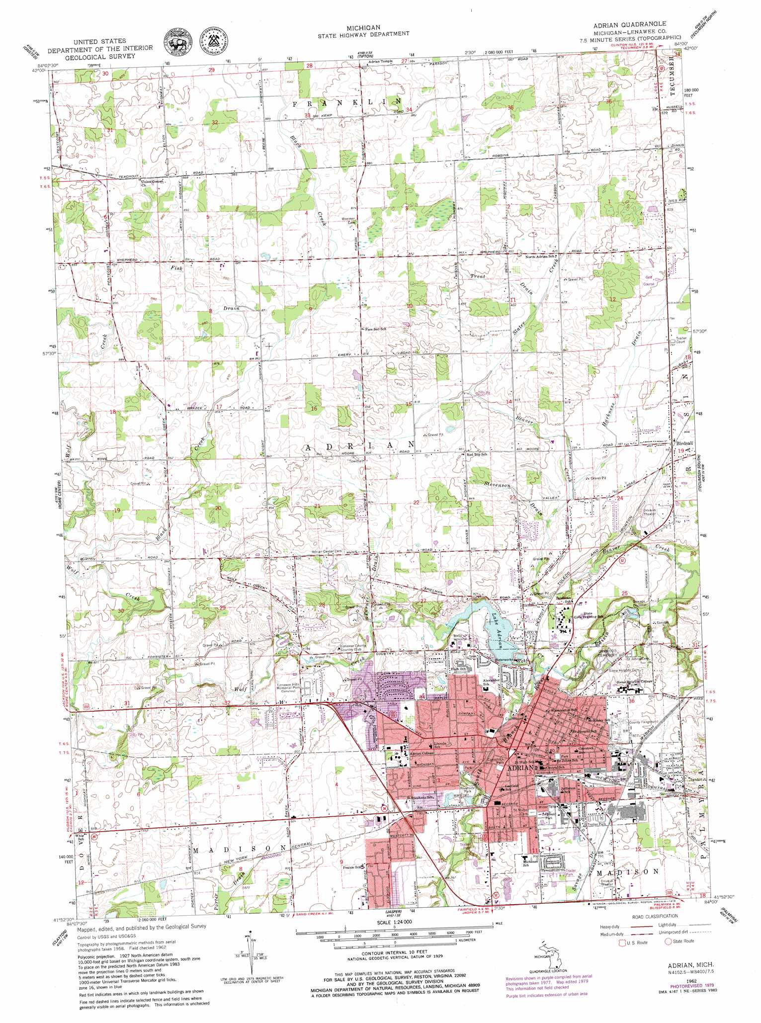
Adrian Topo Map Michigan
To zoom in, hover over the map of Adrian
USGS Topo Quad 41084h1 - 1:24,000 scale
| Topo Map Name: | Adrian |
| USGS Topo Quad ID: | 41084h1 |
| Print Size: | ca. 21 1/4" wide x 27" high |
| Southeast Coordinates: | 41.875° N latitude / 84° W longitude |
| Map Center Coordinates: | 41.9375° N latitude / 84.0625° W longitude |
| U.S. State: | MI |
| Filename: | o41084h1.jpg |
| Download Map JPG Image: | Adrian topo map 1:24,000 scale |
| Map Type: | Topographic |
| Topo Series: | 7.5´ |
| Map Scale: | 1:24,000 |
| Source of Map Images: | United States Geological Survey (USGS) |
| Alternate Map Versions: |
Adrian MI 1962, updated 1963 Download PDF Buy paper map Adrian MI 1962, updated 1978 Download PDF Buy paper map Adrian MI 1962, updated 1979 Download PDF Buy paper map Adrian MI 1962, updated 1979 Download PDF Buy paper map Adrian MI 2011 Download PDF Buy paper map Adrian MI 2014 Download PDF Buy paper map Adrian MI 2016 Download PDF Buy paper map |
1:24,000 Topo Quads surrounding Adrian
Michigan Center |
Norvell |
Manchester |
Bridgewater |
Saline |
Cement City |
Onsted |
Tipton |
Tecumseh North |
Macon |
Addison |
Rome Center |
Adrian |
Tecumseh South |
Deerfield |
Hudson |
Clayton |
Jasper |
Palmyra |
Blissfield |
Fayette |
Morenci |
Lyons |
Assumption |
Berkey |
> Back to 41084e1 at 1:100,000 scale
> Back to 41084a1 at 1:250,000 scale
> Back to U.S. Topo Maps home
Adrian topo map: Gazetteer
Adrian: Airports
Bixby Hospital Heliport elevation 250m 820′Adrian: Parks
Adrian College Historical Marker elevation 244m 800′Adrian Monthly Meetinghouse Historical Marker elevation 237m 777′
Adrian Union Hall Historical Marker elevation 238m 780′
Burr Park elevation 232m 761′
Camp Williams Historical Marker elevation 246m 807′
Christensen Softball Field elevation 252m 826′
Cider Mill Park elevation 229m 751′
Comstock Park elevation 236m 774′
Deerfield Park elevation 246m 807′
Dunlap Park elevation 249m 816′
Erie Street Park elevation 250m 820′
Fee Park elevation 236m 774′
Fourth Michigan Volunteer Infantry Historical Museum elevation 246m 807′
Heritage Park elevation 241m 790′
Hidden River Mobile Home Park elevation 235m 770′
Island Park elevation 221m 725′
Lenawee County Courthouse Historical Marker elevation 236m 774′
Lenawee County Fairgrounds Historical Marker elevation 247m 810′
Monument Park elevation 245m 803′
Oakwood Cemetery Historical Marker elevation 239m 784′
Raisin Valley Friends Church Historical Marker elevation 237m 777′
Riverside Park elevation 227m 744′
Sacred Heart Hall Historical Marker elevation 245m 803′
Saint John's Lutheran Church Historical Marker elevation 242m 793′
Saint Joseph Hospital and Home for the Aged Historical Marker elevation 245m 803′
Saint Joseph Rectory Historical Marker elevation 244m 800′
Saint Joseph School Historical Marker elevation 244m 800′
Saint Joseph's Catholic Church Historical Marker elevation 244m 800′
Second Baptist Church Historical Marker elevation 237m 777′
Thomas A Emmet Senior Tennis Courts elevation 243m 797′
Trestle Park elevation 224m 734′
Waid Park elevation 235m 770′
West Park elevation 233m 764′
Zollar Soccer Field elevation 247m 810′
Adrian: Populated Places
Adrian elevation 237m 777′Birdsall elevation 239m 784′
Friendly Village of Adrian elevation 237m 777′
Kings Court Mobile Park elevation 242m 793′
Maple Woods Manufactured Home Community elevation 246m 807′
Robin Hood Mobile Court elevation 241m 790′
Sterling Estates Mobile Home Park elevation 243m 797′
Adrian: Post Offices
Adrian Post Office elevation 242m 793′Birdsall Post Office (historical) elevation 239m 784′
Adrian: Reservoirs
Lake Adrian elevation 228m 748′Adrian: Streams
Beaver Creek elevation 216m 708′Black Creek elevation 253m 830′
Fisk Drain elevation 262m 859′
Harkness Drain elevation 235m 770′
Hood Drain elevation 247m 810′
Ryan Creek elevation 259m 849′
Slater Creek elevation 243m 797′
Stevenson Drain elevation 234m 767′
Torry Drain elevation 253m 830′
Treat Drain elevation 247m 810′
Turner Drain elevation 233m 764′
Wolf Creek elevation 221m 725′
Adrian digital topo map on disk
Buy this Adrian topo map showing relief, roads, GPS coordinates and other geographical features, as a high-resolution digital map file on DVD:
Northern Illinois, Northern Indiana & Southwestern Michigan
Buy digital topo maps: Northern Illinois, Northern Indiana & Southwestern Michigan