Hudson Topo Map Michigan
To zoom in, hover over the map of Hudson
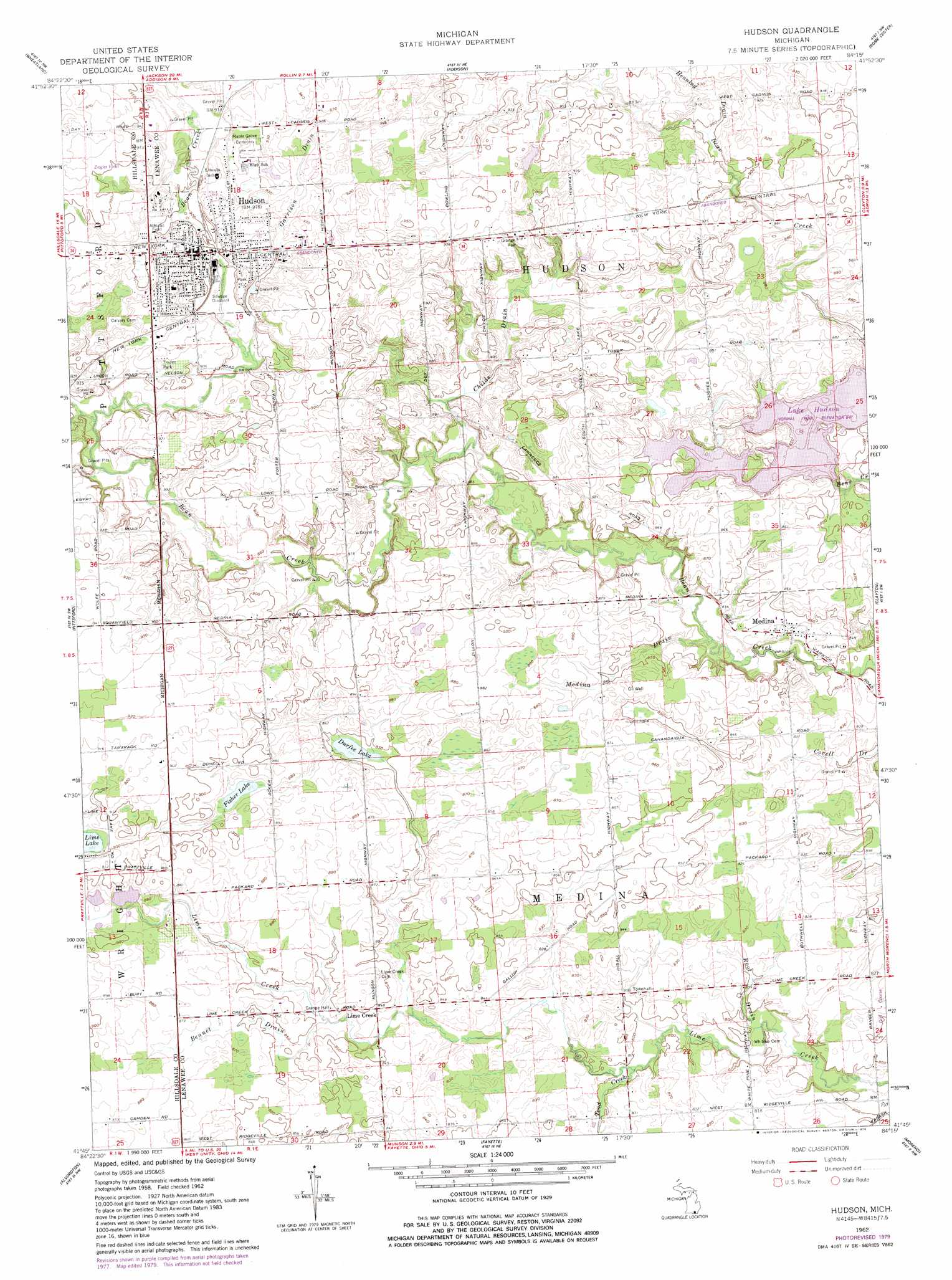
USGS Topo Quad 41084g3 - 1:24,000 scale
| Topo Map Name: | Hudson |
| USGS Topo Quad ID: | 41084g3 |
| Print Size: | ca. 21 1/4" wide x 27" high |
| Southeast Coordinates: | 41.75° N latitude / 84.25° W longitude |
| Map Center Coordinates: | 41.8125° N latitude / 84.3125° W longitude |
| U.S. State: | MI |
| Filename: | o41084g3.jpg |
| Download Map JPG Image: | Hudson topo map 1:24,000 scale |
| Map Type: | Topographic |
| Topo Series: | 7.5´ |
| Map Scale: | 1:24,000 |
| Source of Map Images: | United States Geological Survey (USGS) |
| Alternate Map Versions: |
Hudson MI 1962, updated 1963 Download PDF Buy paper map Hudson MI 1962, updated 1979 Download PDF Buy paper map Hudson MI 1962, updated 1979 Download PDF Buy paper map Hudson MI 2011 Download PDF Buy paper map Hudson MI 2014 Download PDF Buy paper map Hudson MI 2016 Download PDF Buy paper map |
1:24,000 Topo Quads surrounding Hudson
Hanover |
Somerset Center |
Cement City |
Onsted |
Tipton |
North Adams |
Wheatland |
Addison |
Rome Center |
Adrian |
Frontier |
Pittsford |
Hudson |
Clayton |
Jasper |
Pioneer |
Alvordton |
Fayette |
Morenci |
Lyons |
Montpelier |
West Unity |
Archbold |
Wauseon |
Delta |
> Back to 41084e1 at 1:100,000 scale
> Back to 41084a1 at 1:250,000 scale
> Back to U.S. Topo Maps home
Hudson topo map: Gazetteer
Hudson: Airports
Dvoracek Field elevation 298m 977′Thorn Hospital Heliport elevation 283m 928′
Hudson: Lakes
Bear Lake elevation 258m 846′Covell Lake elevation 258m 846′
Durfee Lake elevation 257m 843′
Fisher Lake elevation 266m 872′
Hudson: Parks
Lake Hudson State Park elevation 259m 849′Medina Park elevation 243m 797′
Thompson Memorial Park elevation 274m 898′
Webster's Park elevation 284m 931′
Will Carleton Park elevation 280m 918′
Ziegler Field elevation 290m 951′
Hudson: Populated Places
Hudson elevation 279m 915′Leffingwell Estates Mobile Home Park elevation 279m 915′
Lime Creek elevation 258m 846′
Medina elevation 254m 833′
Hudson: Post Offices
Hudson Post Office elevation 282m 925′Limecreek Post Office (historical) elevation 258m 846′
Medina Post Office (historical) elevation 254m 833′
Hudson: Reservoirs
Lake Hudson elevation 256m 839′Hudson: Streams
Bennet Drain elevation 253m 830′Camp Drain elevation 258m 846′
Childs Drain elevation 253m 830′
Garrison Drain elevation 270m 885′
Henning Drain elevation 273m 895′
J B Drain elevation 258m 846′
Mallory Lake Drain elevation 265m 869′
Medina Drain elevation 247m 810′
Root Drain elevation 238m 780′
Toad Creek elevation 253m 830′
Hudson digital topo map on disk
Buy this Hudson topo map showing relief, roads, GPS coordinates and other geographical features, as a high-resolution digital map file on DVD:
Northern Illinois, Northern Indiana & Southwestern Michigan
Buy digital topo maps: Northern Illinois, Northern Indiana & Southwestern Michigan