Blissfield Topo Map Michigan
To zoom in, hover over the map of Blissfield
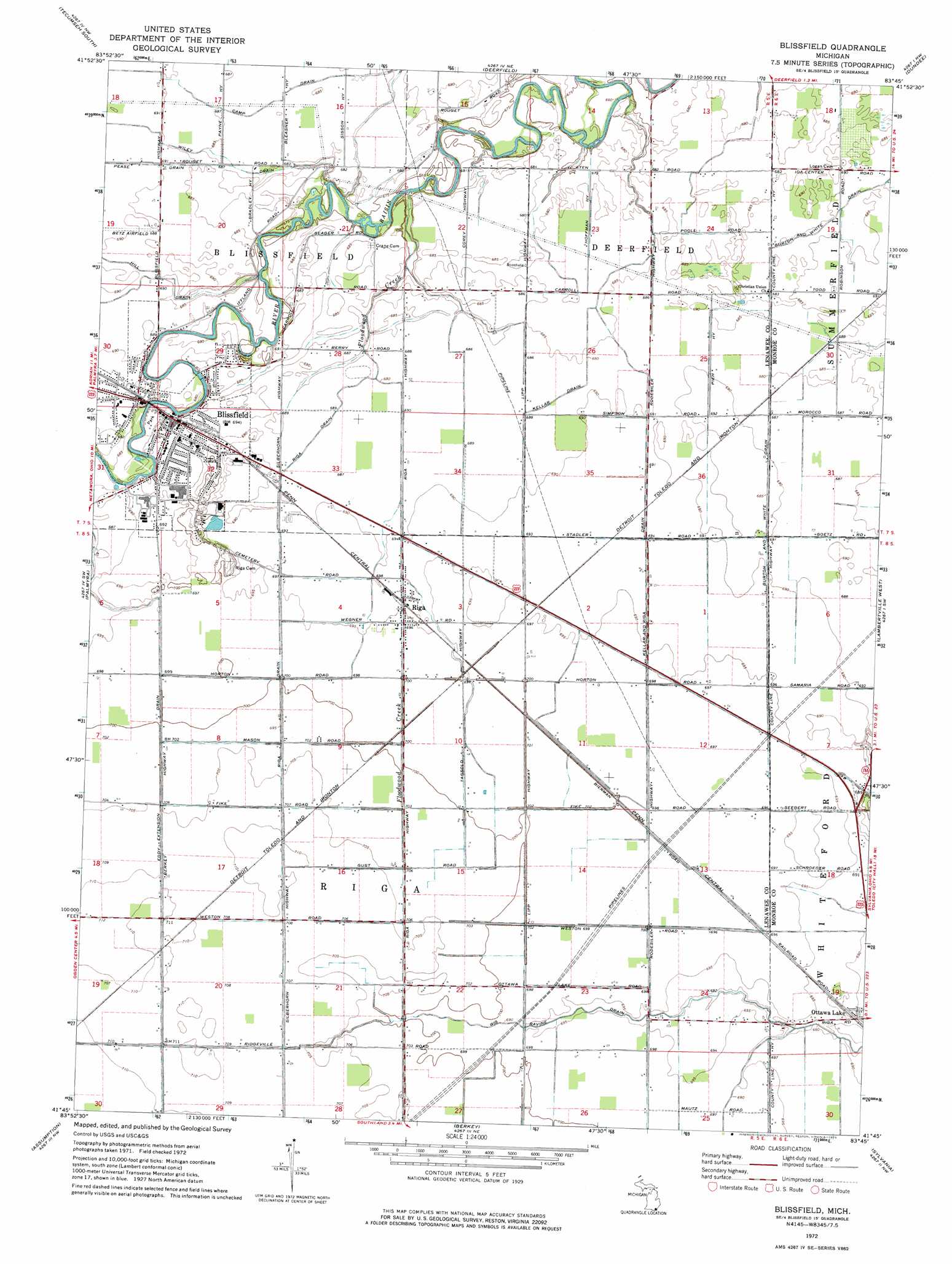
USGS Topo Quad 41083g7 - 1:24,000 scale
| Topo Map Name: | Blissfield |
| USGS Topo Quad ID: | 41083g7 |
| Print Size: | ca. 21 1/4" wide x 27" high |
| Southeast Coordinates: | 41.75° N latitude / 83.75° W longitude |
| Map Center Coordinates: | 41.8125° N latitude / 83.8125° W longitude |
| U.S. State: | MI |
| Filename: | o41083g7.jpg |
| Download Map JPG Image: | Blissfield topo map 1:24,000 scale |
| Map Type: | Topographic |
| Topo Series: | 7.5´ |
| Map Scale: | 1:24,000 |
| Source of Map Images: | United States Geological Survey (USGS) |
| Alternate Map Versions: |
Blissfield MI 1972, updated 1975 Download PDF Buy paper map Blissfield MI 2011 Download PDF Buy paper map Blissfield MI 2014 Download PDF Buy paper map Blissfield MI 2016 Download PDF Buy paper map |
1:24,000 Topo Quads surrounding Blissfield
Tipton |
Tecumseh North |
Macon |
Milan |
Maybee |
Adrian |
Tecumseh South |
Deerfield |
Dundee |
Ida |
Jasper |
Palmyra |
Blissfield |
Lambertville West |
Lambertville East |
Lyons |
Assumption |
Berkey |
Sylvania |
Toledo |
Delta |
Swanton |
Whitehouse |
Maumee |
Rossford |
> Back to 41083e1 at 1:100,000 scale
> Back to 41082a1 at 1:250,000 scale
> Back to U.S. Topo Maps home
Blissfield topo map: Gazetteer
Blissfield: Airports
Betz Airport elevation 210m 688′Blissfield: Canals
Eddy Extension Drain elevation 214m 702′Hill Drain elevation 207m 679′
Kellar and Riga Drain elevation 210m 688′
Kellar Drain elevation 209m 685′
Pease Drain elevation 210m 688′
Ravine Drain elevation 210m 688′
Riga Drain elevation 212m 695′
Wiley Drain elevation 209m 685′
Blissfield: Parks
Bachmayer Little League Park elevation 210m 688′Bachmayer Park elevation 208m 682′
Blissfield Hotel Historical Marker elevation 211m 692′
Carpenter House Historical Marker elevation 210m 688′
Ellis Park elevation 207m 679′
Erie and Kalamazoo Railroad Historical Marker elevation 210m 688′
Farver Little League Park elevation 212m 695′
First Presbyterian Church Historical Marker elevation 210m 688′
Hiram D Ellis House Historical Marker elevation 210m 688′
Blissfield: Populated Places
Blissfield elevation 210m 688′Riga elevation 212m 695′
Blissfield: Post Offices
Blissfield Post Office elevation 210m 688′Riga Post Office elevation 212m 695′
Blissfield: Streams
Floodwood Creek elevation 204m 669′Blissfield digital topo map on disk
Buy this Blissfield topo map showing relief, roads, GPS coordinates and other geographical features, as a high-resolution digital map file on DVD:
 map DVD")