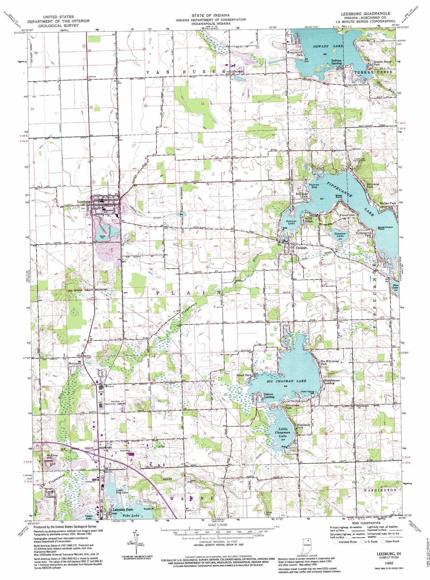
Leesburg Topo Map Indiana
To zoom in, hover over the map of Leesburg
USGS Topo Quad 41085c7 - 1:24,000 scale
| Topo Map Name: | Leesburg |
| USGS Topo Quad ID: | 41085c7 |
| Print Size: | ca. 21 1/4" wide x 27" high |
| Southeast Coordinates: | 41.25° N latitude / 85.75° W longitude |
| Map Center Coordinates: | 41.3125° N latitude / 85.8125° W longitude |
| U.S. State: | IN |
| Filename: | o41085c7.jpg |
| Download Map JPG Image: | Leesburg topo map 1:24,000 scale |
| Map Type: | Topographic |
| Topo Series: | 7.5´ |
| Map Scale: | 1:24,000 |
| Source of Map Images: | United States Geological Survey (USGS) |
| Alternate Map Versions: |
Leesburg IN 1950, updated 1952 Download PDF Buy paper map Leesburg IN 1962, updated 1964 Download PDF Buy paper map Leesburg IN 1962, updated 1982 Download PDF Buy paper map Leesburg IN 1992, updated 1995 Download PDF Buy paper map Leesburg IN 2010 Download PDF Buy paper map Leesburg IN 2013 Download PDF Buy paper map Leesburg IN 2016 Download PDF Buy paper map |
1:24,000 Topo Quads surrounding Leesburg
Wakarusa |
Foraker |
Goshen |
Millersburg |
Topeka |
Nappanee West |
Nappanee East |
Milford |
Lake Wawasee |
Ligonier |
Bourbon |
Atwood |
Leesburg |
North Webster |
Ormas |
Mentone |
Burket |
Warsaw |
Pierceton |
Lorane |
Akron |
Silver Lake |
North Manchester North |
South Whitley West |
South Whitley East |
> Back to 41085a1 at 1:100,000 scale
> Back to 41084a1 at 1:250,000 scale
> Back to U.S. Topo Maps home
Leesburg topo map: Gazetteer
Leesburg: Airports
Warsaw Municipal Airport elevation 256m 839′Leesburg: Canals
Heeter Ditch elevation 251m 823′Hickman Ditch elevation 252m 826′
Kohler Ditch elevation 258m 846′
Lones Ditch elevation 246m 807′
Long Ditch elevation 257m 843′
Ruple Ditch elevation 256m 839′
Westlake Ditch elevation 269m 882′
Leesburg: Capes
Government Point elevation 255m 836′Leesburg: Channels
Old Channel Kankakee River elevation 255m 836′Leesburg: Lakes
Dewart Lake elevation 263m 862′Little Chapman Lake elevation 252m 826′
Little Pike Lake elevation 245m 803′
Stanton Lake elevation 256m 839′
Tippecanoe Lake elevation 253m 830′
Leesburg: Populated Places
Arrowhead Park elevation 255m 836′Bell Rohr Park elevation 257m 843′
DeFries Landing elevation 265m 869′
Forest Glen elevation 259m 849′
Highlands Park elevation 260m 853′
Island Park elevation 254m 833′
Kalorama Park elevation 271m 889′
Lakeside Park elevation 250m 820′
Leesburg elevation 261m 856′
Monoquet elevation 258m 846′
Musquabuck Park elevation 271m 889′
Osborn Landing elevation 253m 830′
Oswego elevation 260m 853′
Potawatomi Park elevation 257m 843′
Quaker Haven Park elevation 270m 885′
Silver Point elevation 256m 839′
Stoneburner Landing elevation 254m 833′
Stony Ridge elevation 258m 846′
Walker Park elevation 260m 853′
Wa-Will-Away Park elevation 262m 859′
Leesburg: Reservoirs
Big Chapman Lake elevation 251m 823′Oswego Lake elevation 254m 833′
Patona Bay elevation 254m 833′
Leesburg: Streams
Cable Run elevation 268m 879′Deeds Creek elevation 246m 807′
Leesburg: Summits
McElroy Hill elevation 254m 833′Leesburg digital topo map on disk
Buy this Leesburg topo map showing relief, roads, GPS coordinates and other geographical features, as a high-resolution digital map file on DVD:
Northern Illinois, Northern Indiana & Southwestern Michigan
Buy digital topo maps: Northern Illinois, Northern Indiana & Southwestern Michigan