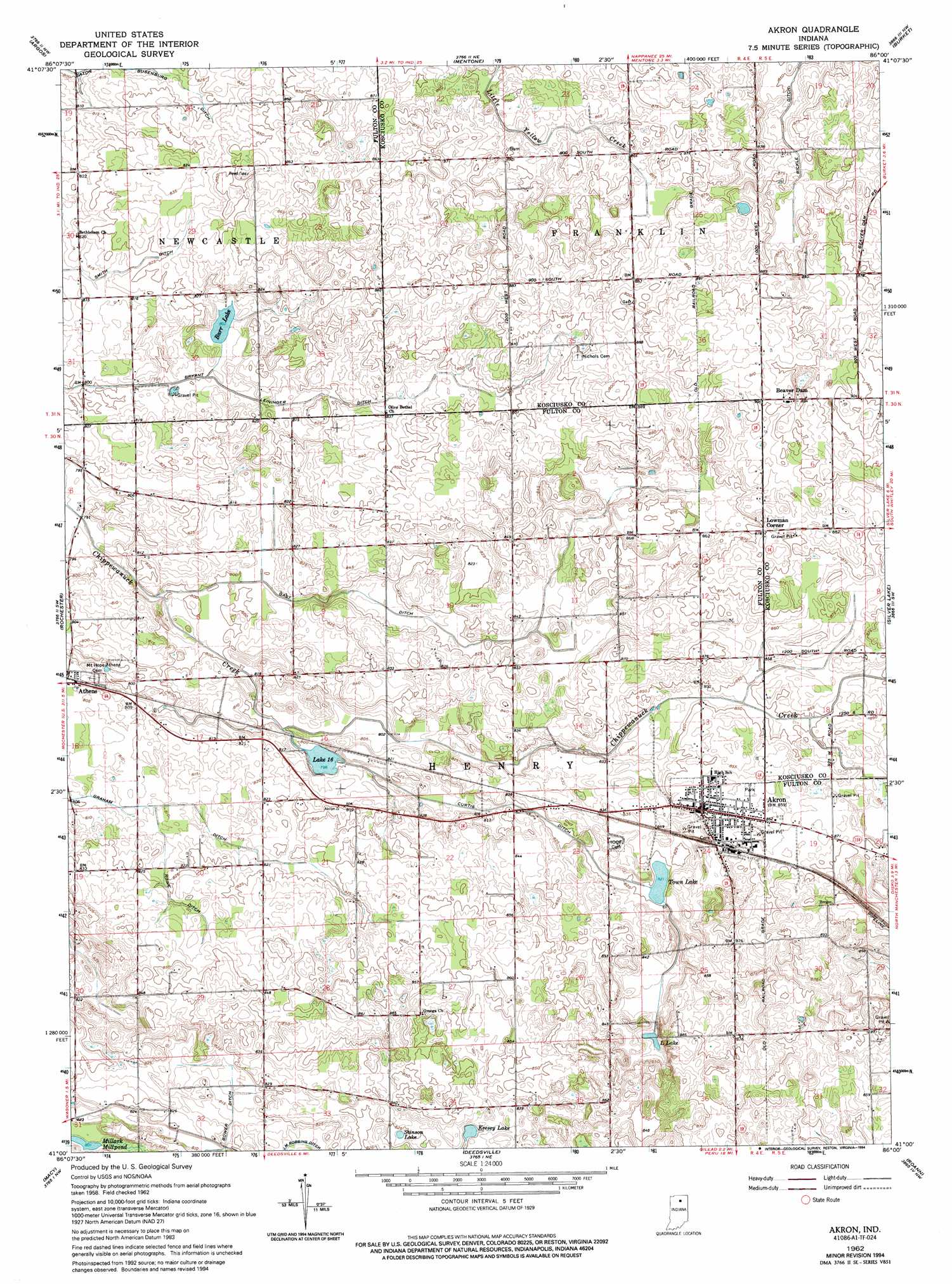
Akron Topo Map Indiana
To zoom in, hover over the map of Akron
USGS Topo Quad 41086a1 - 1:24,000 scale
| Topo Map Name: | Akron |
| USGS Topo Quad ID: | 41086a1 |
| Print Size: | ca. 21 1/4" wide x 27" high |
| Southeast Coordinates: | 41° N latitude / 86° W longitude |
| Map Center Coordinates: | 41.0625° N latitude / 86.0625° W longitude |
| U.S. State: | IN |
| Filename: | o41086a1.jpg |
| Download Map JPG Image: | Akron topo map 1:24,000 scale |
| Map Type: | Topographic |
| Topo Series: | 7.5´ |
| Map Scale: | 1:24,000 |
| Source of Map Images: | United States Geological Survey (USGS) |
| Alternate Map Versions: |
Akron IN 1962, updated 1964 Download PDF Buy paper map Akron IN 1962, updated 1984 Download PDF Buy paper map Akron IN 1962, updated 1994 Download PDF Buy paper map Akron IN 2010 Download PDF Buy paper map Akron IN 2013 Download PDF Buy paper map Akron IN 2016 Download PDF Buy paper map |
1:24,000 Topo Quads surrounding Akron
Plymouth |
Inwood |
Bourbon |
Atwood |
Leesburg |
Rutland |
Argos |
Mentone |
Burket |
Warsaw |
Pershing |
Rochester |
Akron |
Silver Lake |
North Manchester North |
Fulton |
Macy |
Deedsville |
Roann |
North Manchester South |
Logansport |
Twelve Mile |
Peru |
Richvalley |
Wabash |
> Back to 41086a1 at 1:100,000 scale
> Back to 41086a1 at 1:250,000 scale
> Back to U.S. Topo Maps home
Akron topo map: Gazetteer
Akron: Canals
Bryant Leininger Ditch elevation 250m 820′Curtis Ditch elevation 251m 823′
Gast Ditch elevation 250m 820′
Graham Ditch elevation 245m 803′
Rickle Ditch elevation 258m 846′
Rowe Ditch elevation 252m 826′
Akron: Lakes
Barr Lake elevation 245m 803′Keesey Lake elevation 251m 823′
L Lake elevation 253m 830′
Lake Sixteen elevation 244m 800′
Stinson Lake elevation 250m 820′
Town Lake elevation 251m 823′
Akron: Populated Places
Akron elevation 260m 853′Beaver Dam elevation 274m 898′
Lowman Corner elevation 268m 879′
Akron digital topo map on disk
Buy this Akron topo map showing relief, roads, GPS coordinates and other geographical features, as a high-resolution digital map file on DVD:
Northern Illinois, Northern Indiana & Southwestern Michigan
Buy digital topo maps: Northern Illinois, Northern Indiana & Southwestern Michigan