Lake Calumet Topo Map Illinois
To zoom in, hover over the map of Lake Calumet
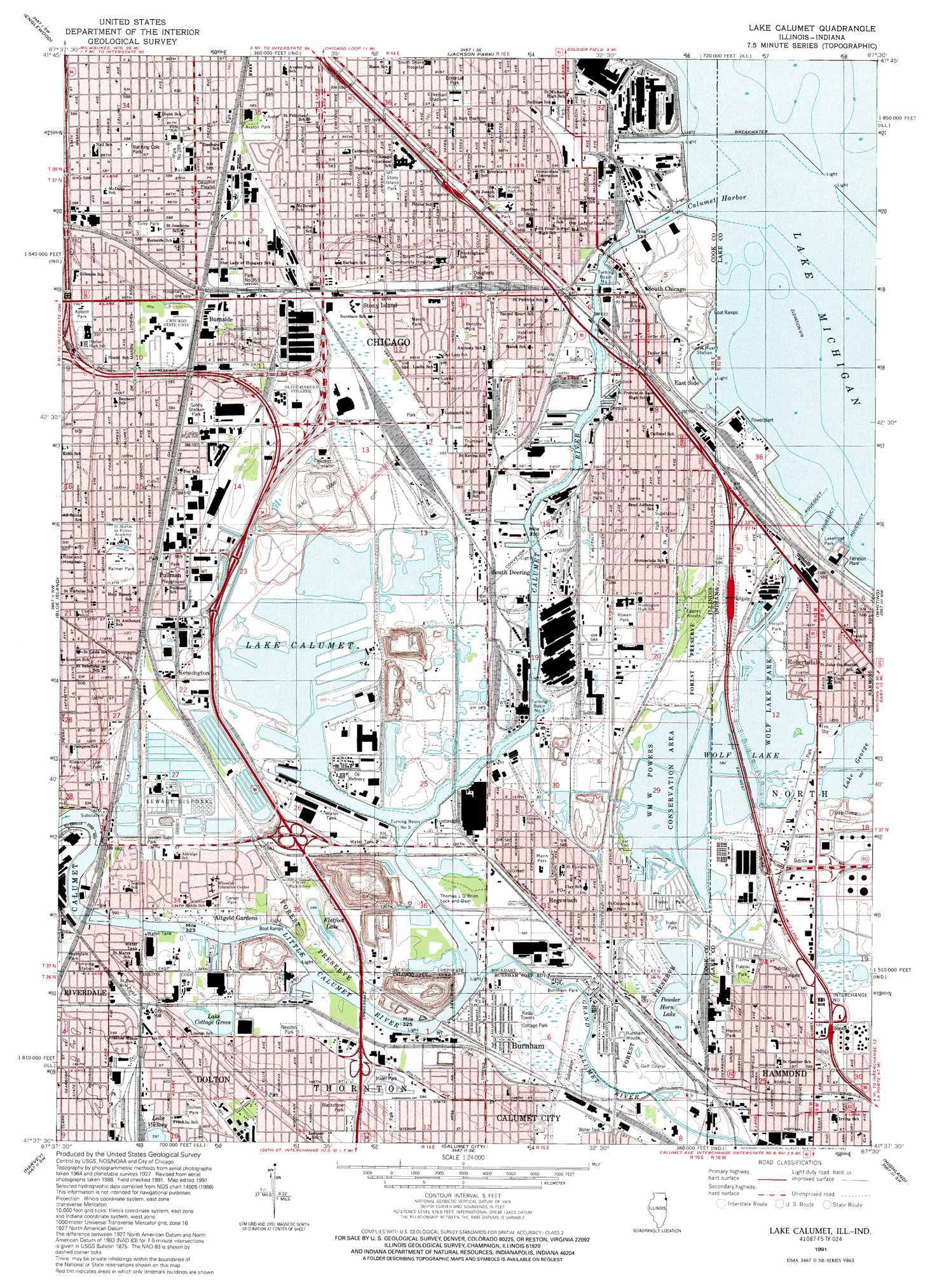
USGS Topo Quad 41087f5 - 1:24,000 scale
| Topo Map Name: | Lake Calumet |
| USGS Topo Quad ID: | 41087f5 |
| Print Size: | ca. 21 1/4" wide x 27" high |
| Southeast Coordinates: | 41.625° N latitude / 87.5° W longitude |
| Map Center Coordinates: | 41.6875° N latitude / 87.5625° W longitude |
| U.S. States: | IL, IN |
| Filename: | o41087f5.jpg |
| Download Map JPG Image: | Lake Calumet topo map 1:24,000 scale |
| Map Type: | Topographic |
| Topo Series: | 7.5´ |
| Map Scale: | 1:24,000 |
| Source of Map Images: | United States Geological Survey (USGS) |
| Alternate Map Versions: |
Calumet Lake IL 1929, updated 1939 Download PDF Buy paper map Calumet Lake IL 1929, updated 1939 Download PDF Buy paper map Calumet Lake IL 1953, updated 1955 Download PDF Buy paper map Lake Calumet IL 1960, updated 1962 Download PDF Buy paper map Lake Calumet IL 1965, updated 1966 Download PDF Buy paper map Lake Calumet IL 1965, updated 1974 Download PDF Buy paper map Lake Calumet IL 1965, updated 1983 Download PDF Buy paper map Lake Calumet IL 1965, updated 1989 Download PDF Buy paper map Lake Calumet IL 1991, updated 1992 Download PDF Buy paper map Lake Calumet IL 1997, updated 1999 Download PDF Buy paper map Lake Calumet IL 2012 Download PDF Buy paper map Lake Calumet IL 2015 Download PDF Buy paper map |
1:24,000 Topo Quads surrounding Lake Calumet
River Forest |
Chicago Loop |
|||
Berwyn |
Englewood |
Jackson Park |
||
Palos Park |
Blue Island |
Lake Calumet |
Whiting |
|
Tinley Park |
Harvey |
Calumet City |
Highland |
Gary |
Frankfort |
Steger |
Dyer |
Saint John |
Crown Point |
> Back to 41087e1 at 1:100,000 scale
> Back to 41086a1 at 1:250,000 scale
> Back to U.S. Topo Maps home
Lake Calumet topo map: Gazetteer
Lake Calumet: Airports
Pielet-Calumet Heliport elevation 179m 587′Waste Management Chemical Lab Heliport elevation 183m 600′
Lake Calumet: Areas
High Prairie elevation 185m 606′Lake Calumet: Bars
Calumet Bar elevation 175m 574′Lake Calumet: Beaches
Calumet Park Beach elevation 178m 583′Munson Beach elevation 176m 577′
Lake Calumet: Crossings
Interchange 61 elevation 178m 583′Interchange 62 elevation 179m 587′
Interchange 63 elevation 177m 580′
Interchange 65 elevation 180m 590′
Interchange 66 elevation 179m 587′
Interchange 68 elevation 182m 597′
Interchange 70 elevation 181m 593′
Interchange Number 1 elevation 178m 583′
Lake Calumet: Dams
Thomas J O'Brien Lock and Dam elevation 177m 580′Lake Calumet: Harbors
Calumet Harbor elevation 175m 574′Calumet Harbor elevation 175m 574′
Howard Slip elevation 175m 574′
North Slip elevation 175m 574′
Rock Island Slip (historical) elevation 178m 583′
Turning Basin Number 1 elevation 175m 574′
Turning Basin Number 3 elevation 175m 574′
Turning Basin Number 5 elevation 175m 574′
Lake Calumet: Lakes
Dead Stick Pond elevation 176m 577′Flatfoot Lake elevation 177m 580′
Gun Club Ponds elevation 179m 587′
Lake Calumet elevation 178m 583′
Lake Cottage Grove elevation 180m 590′
Lake George elevation 178m 583′
Lake Victory elevation 181m 593′
Powder Horn Lake elevation 178m 583′
Wolf Lake elevation 178m 583′
Wolf Lake elevation 178m 583′
Lake Calumet: Parks
Abbott Park elevation 182m 597′Alfred D Kohn Playground elevation 183m 600′
Avalon Park elevation 179m 587′
Beaubien Forest Preserve elevation 183m 600′
Bensley Park elevation 178m 583′
Bessemer Park elevation 178m 583′
Blackstone Park elevation 179m 587′
Burnham Park elevation 178m 583′
Calumet Park elevation 181m 593′
Carver Park elevation 178m 583′
Cottage Park elevation 178m 583′
Dauphin Playlot elevation 181m 593′
Dolton Park elevation 184m 603′
Dougherty Park elevation 178m 583′
Eckersall Park elevation 178m 583′
Eckersall Stadium elevation 178m 583′
Eckersall Stadium elevation 178m 583′
Forsyth Park elevation 178m 583′
Fowney Park elevation 180m 590′
G R Clark Athletic Field elevation 179m 587′
Gately Stadium Park elevation 182m 597′
Golden Gate Park elevation 180m 590′
Hermit Park elevation 179m 587′
Kensington Park elevation 182m 597′
Kiwanis Field elevation 184m 603′
Lakefront Park elevation 178m 583′
Lion Field elevation 183m 600′
Luella Park elevation 178m 583′
Mann Park elevation 179m 587′
Merrill Park elevation 178m 583′
Nat King Cole Park elevation 180m 590′
Needles Park elevation 179m 587′
Palmer Park elevation 179m 587′
Park Number 289 elevation 180m 590′
Pietrowski Playground Park elevation 181m 593′
Pulaski Park elevation 178m 583′
Pullman Park elevation 180m 590′
Rowan Park elevation 178m 583′
Russell Park elevation 179m 587′
Stony Island Park elevation 181m 593′
Trumbull Park elevation 179m 587′
Tuley Park elevation 179m 587′
Veterans Park elevation 178m 583′
Wm W Powers Conservation Area elevation 178m 583′
Wolf Lake Park elevation 179m 587′
Wolfe Park elevation 178m 583′
Lake Calumet: Populated Places
Altgeld Gardens elevation 179m 587′Arcade Row elevation 180m 590′
Avalon Highlands elevation 179m 587′
Avalon Park elevation 181m 593′
Burnham elevation 178m 583′
Burnside elevation 179m 587′
Burnside elevation 178m 583′
Calumet elevation 180m 590′
Calumet Heights elevation 178m 583′
Chatham elevation 180m 590′
Chatham Fields elevation 180m 590′
Cheltenham elevation 178m 583′
Dauphin Park elevation 181m 593′
Dolton elevation 184m 603′
East Side elevation 183m 600′
Garden Homes elevation 179m 587′
Green Bay elevation 180m 590′
Hegewisch elevation 178m 583′
Honeymoon Row elevation 180m 590′
Irondale elevation 179m 587′
Irondale (historical) elevation 178m 583′
Ironworkers Addition to South Chicago elevation 179m 587′
Jeffery Manor elevation 179m 587′
Kensington elevation 180m 590′
Merrionette Manor elevation 180m 590′
North Pullman elevation 182m 597′
Philip Murray Homes elevation 179m 587′
Pierces Park elevation 181m 593′
Pullman elevation 180m 590′
Riverdale elevation 178m 583′
Robertsdale elevation 178m 583′
Sheffield Estates elevation 178m 583′
South Chicago elevation 180m 590′
South Chicago Heights elevation 180m 590′
South Deering elevation 179m 587′
South Pole elevation 178m 583′
Stony Island elevation 182m 597′
Stony Island Heights elevation 184m 603′
Taylors Addition to South Chicago elevation 180m 590′
The Bush elevation 178m 583′
The Cottage elevation 180m 590′
Trumbull Park Homes elevation 179m 587′
Trumbull Park Terrace elevation 178m 583′
Lake Calumet: Post Offices
Hope Post Office (historical) elevation 185m 606′Lake Calumet: Reservoirs
Calumet River elevation 177m 580′Lake Calumet: Ridges
Stony Island Ridge elevation 184m 603′Lake Calumet: Streams
Calumet River elevation 175m 574′East Arm Little Calumet River elevation 177m 580′
Grand Calumet River elevation 177m 580′
Grand Calumet River elevation 177m 580′
Little Calumet River elevation 177m 580′
Lake Calumet: Swamps
Big Marsh elevation 178m 583′Hegewisch Marsh elevation 178m 583′
Hyde Lake Wetlands elevation 180m 590′
Indian Ridge Marsh elevation 179m 587′
Lake Calumet: Woods
Burnham Woods elevation 178m 583′Eggers Woods elevation 178m 583′
Lake Calumet digital topo map on disk
Buy this Lake Calumet topo map showing relief, roads, GPS coordinates and other geographical features, as a high-resolution digital map file on DVD:
Northern Illinois, Northern Indiana & Southwestern Michigan
Buy digital topo maps: Northern Illinois, Northern Indiana & Southwestern Michigan