Iowa City West Topo Map Iowa
To zoom in, hover over the map of Iowa City West
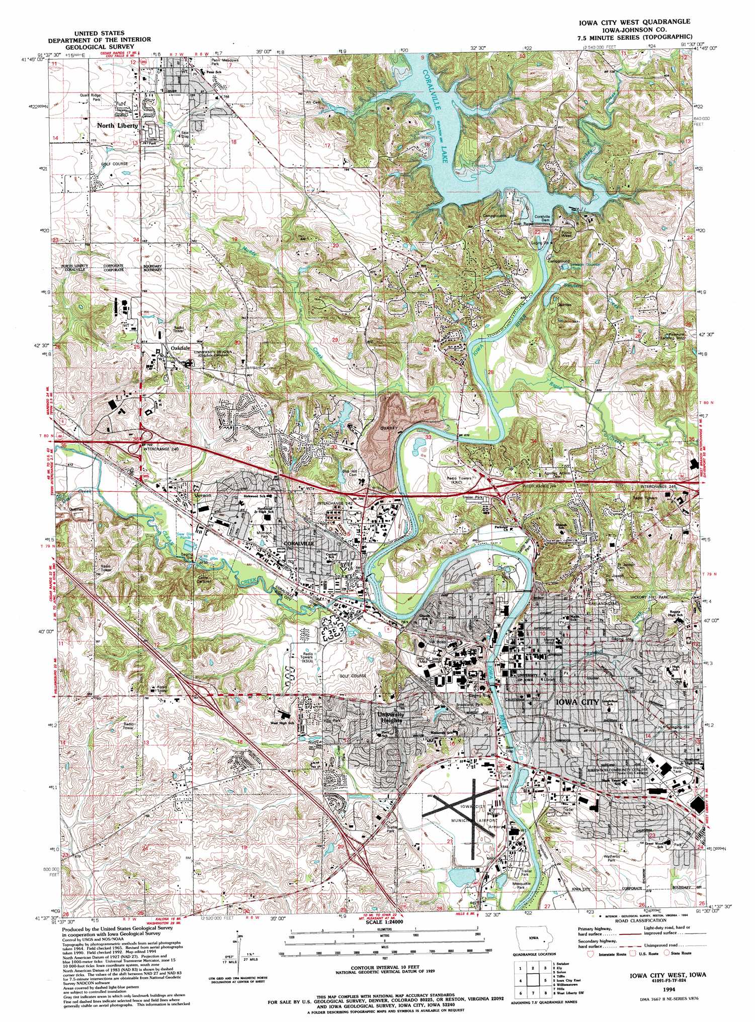
USGS Topo Quad 41091f5 - 1:24,000 scale
| Topo Map Name: | Iowa City West |
| USGS Topo Quad ID: | 41091f5 |
| Print Size: | ca. 21 1/4" wide x 27" high |
| Southeast Coordinates: | 41.625° N latitude / 91.5° W longitude |
| Map Center Coordinates: | 41.6875° N latitude / 91.5625° W longitude |
| U.S. State: | IA |
| Filename: | o41091f5.jpg |
| Download Map JPG Image: | Iowa City West topo map 1:24,000 scale |
| Map Type: | Topographic |
| Topo Series: | 7.5´ |
| Map Scale: | 1:24,000 |
| Source of Map Images: | United States Geological Survey (USGS) |
| Alternate Map Versions: |
Iowa City West IA 1965, updated 1967 Download PDF Buy paper map Iowa City West IA 1965, updated 1974 Download PDF Buy paper map Iowa City West IA 1965, updated 1983 Download PDF Buy paper map Iowa City West IA 1994, updated 1994 Download PDF Buy paper map Iowa City West IA 1994, updated 1994 Download PDF Buy paper map Iowa City West IA 2010 Download PDF Buy paper map Iowa City West IA 2013 Download PDF Buy paper map Iowa City West IA 2015 Download PDF Buy paper map |
1:24,000 Topo Quads surrounding Iowa City West
Fairfax |
Cedar Rapids South |
Bertram |
Mount Vernon |
Mechanicsville |
Amana |
Swisher |
Ely |
Solon |
Cedar Bluff |
Oxford |
Tiffin |
Iowa City West |
Iowa City East |
West Branch |
Amish |
Williamstown |
Hills |
West Liberty Sw |
West Liberty |
Wellman |
Kalona |
Riverside |
Lone Tree |
Nichols |
> Back to 41091e1 at 1:100,000 scale
> Back to 41090a1 at 1:250,000 scale
> Back to U.S. Topo Maps home
Iowa City West topo map: Gazetteer
Iowa City West: Airports
Iowa City Municipal Airport elevation 199m 652′Picayune Airport elevation 246m 807′
University of Iowa Hospitals and Clinic Heliport elevation 219m 718′
University of Iowa Hospitals and Clinic Number 2 Heliport elevation 220m 721′
Iowa City West: Crossings
Interchange 240 elevation 218m 715′Interchange 242 elevation 219m 718′
Interchange 244 elevation 225m 738′
Iowa City West: Dams
Coralville Dam elevation 226m 741′Iowa City West: Parks
Auburn Hills Park elevation 233m 764′Bend Park elevation 218m 715′
Central Park elevation 207m 679′
Chauncey Swan Circle Historical Marker elevation 197m 646′
College Green Park elevation 201m 659′
Cordelia Swan Historical Marker elevation 234m 767′
Crandic Park elevation 196m 643′
Creekside Park elevation 209m 685′
Duane Banks Baseball Stadium elevation 217m 711′
Edgewater Park elevation 196m 643′
Fairmeadows Park elevation 212m 695′
First Territorial Commissioner Historical Marker elevation 201m 659′
Grant Field elevation 217m 711′
Happy Hollow Park elevation 218m 715′
Hickory Hill Park elevation 207m 679′
Hubbard Park elevation 198m 649′
Hunters Run Park elevation 230m 754′
Iowa City City Park elevation 197m 646′
Kinnick Stadium elevation 221m 725′
Kiwanis Park elevation 210m 688′
Morrison Park elevation 210m 688′
Napoleon Park elevation 195m 639′
Nathaniel Fellows Historical Marker elevation 235m 770′
North Market Park elevation 207m 679′
North Ridge Park elevation 221m 725′
Oak Grove Park elevation 209m 685′
Old Limestone Shaft Historical Marker elevation 214m 702′
Penn Meadows Park elevation 242m 793′
Portrait of Sir William Blackstone Historical Marker elevation 211m 692′
Samuel Jordan Kirkwood State Historical Marker elevation 201m 659′
Site of Mormon Handcart Brigade Camp Historical Marker elevation 208m 682′
Sturgis Ferry Park elevation 198m 649′
Terrill Mill Park elevation 195m 639′
Villa Park elevation 221m 725′
Wetherby Park elevation 217m 711′
Willow Creek Park elevation 207m 679′
Iowa City West: Populated Places
Baculis Mobile Home Park elevation 194m 636′Coral Trailer Park elevation 208m 682′
Coralville elevation 208m 682′
Forest View Trailer Court elevation 219m 718′
Hilltop Mobile Home Park elevation 201m 659′
Holiday Mobile Home Court elevation 231m 757′
Iowa City elevation 204m 669′
North Liberty elevation 238m 780′
Oakdale elevation 246m 807′
University Heights elevation 233m 764′
Vernon elevation 208m 682′
Iowa City West: Post Offices
Coralville Post Office elevation 208m 682′Iowa City Post Office elevation 210m 688′
North Liberty Post Office elevation 238m 780′
Oakdale Post Office elevation 246m 807′
Iowa City West: Streams
Clear Creek elevation 193m 633′Deer Creek elevation 201m 659′
Muddy Creek elevation 197m 646′
Ralston Creek elevation 192m 629′
Rapid Creek elevation 199m 652′
Sanders Creek elevation 200m 656′
Turkey Creek elevation 207m 679′
Iowa City West digital topo map on disk
Buy this Iowa City West topo map showing relief, roads, GPS coordinates and other geographical features, as a high-resolution digital map file on DVD: