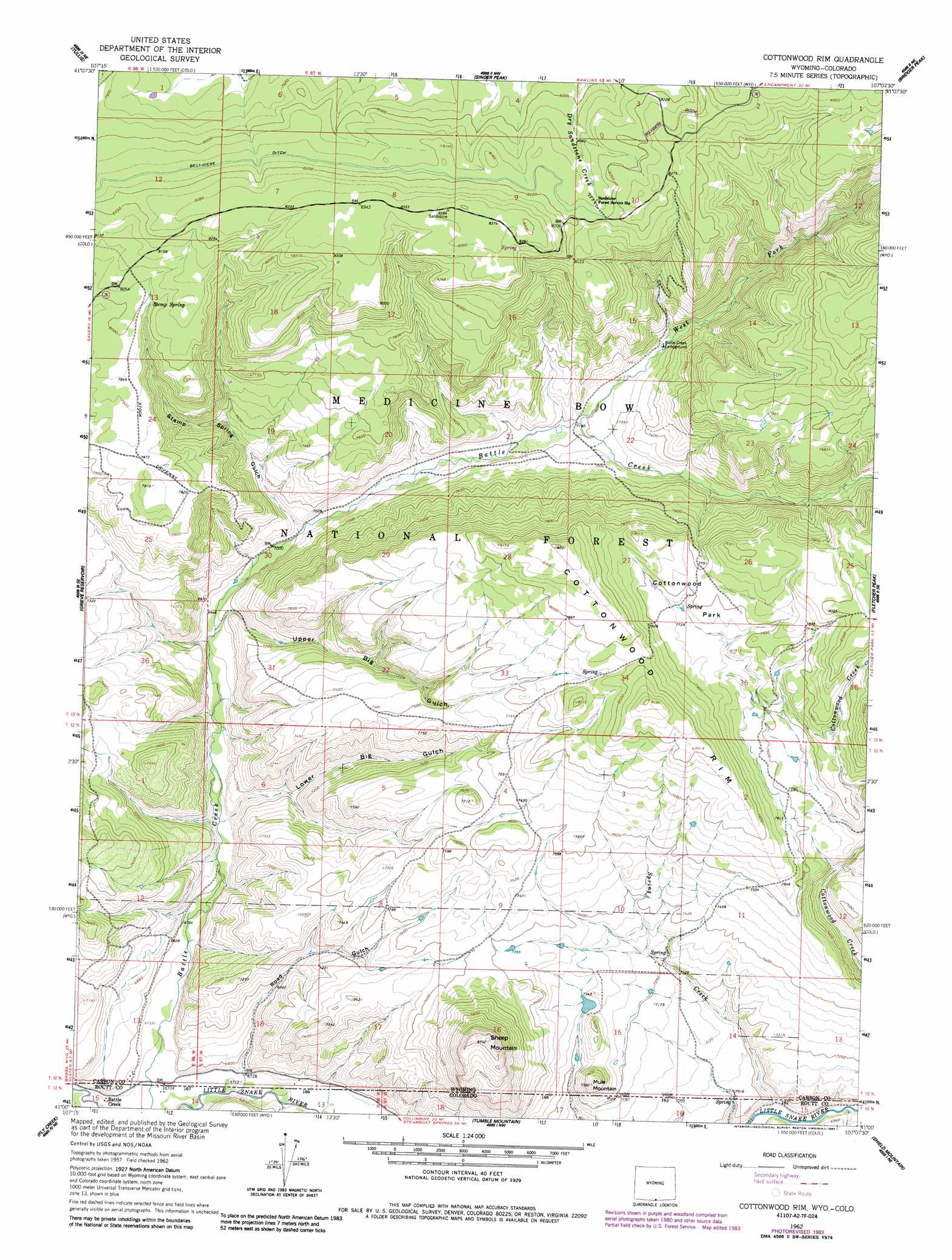
Cottonwood Rim Topo Map Wyoming
To zoom in, hover over the map of Cottonwood Rim
USGS Topo Quad 41107a2 - 1:24,000 scale
| Topo Map Name: | Cottonwood Rim |
| USGS Topo Quad ID: | 41107a2 |
| Print Size: | ca. 21 1/4" wide x 27" high |
| Southeast Coordinates: | 41° N latitude / 107.125° W longitude |
| Map Center Coordinates: | 41.0625° N latitude / 107.1875° W longitude |
| U.S. States: | WY, CO |
| Filename: | o41107a2.jpg |
| Download Map JPG Image: | Cottonwood Rim topo map 1:24,000 scale |
| Map Type: | Topographic |
| Topo Series: | 7.5´ |
| Map Scale: | 1:24,000 |
| Source of Map Images: | United States Geological Survey (USGS) |
| Alternate Map Versions: |
Cottonwood Rim WY 1962, updated 1963 Download PDF Buy paper map Cottonwood Rim WY 1962, updated 1975 Download PDF Buy paper map Cottonwood Rim WY 1962, updated 1984 Download PDF Buy paper map Cottonwood Rim WY 1962, updated 1984 Download PDF Buy paper map Cottonwood Rim WY 2012 Download PDF Buy paper map Cottonwood Rim WY 2015 Download PDF Buy paper map |
| FStopo: | US Forest Service topo Cottonwood Rim is available: Download FStopo PDF Download FStopo TIF |
1:24,000 Topo Quads surrounding Cottonwood Rim
Ketchum Buttes |
Mccarty Ranch |
Divide Peak |
Sharp Hill |
Indian Rocks |
Browns Hill |
Tullis |
Singer Peak |
Bridger Peak |
Red Mountain |
Savery |
Grieve Reservoir |
Cottonwood Rim |
Fletcher Peak |
Solomon Creek |
Bakers Peak |
Fly Creek |
Tumble Mountain |
Shield Mountain |
Elkhorn Mountain |
Freeman Reservoir |
Buck Point |
Bears Ears Peaks |
Meaden Peak |
Hahns Peak |
> Back to 41107a1 at 1:100,000 scale
> Back to 41106a1 at 1:250,000 scale
> Back to U.S. Topo Maps home
Cottonwood Rim topo map: Gazetteer
Cottonwood Rim: Canals
Belvidere Ditch elevation 2476m 8123′Cottonwood Rim: Cliffs
Cottonwood Rim elevation 2502m 8208′Cottonwood Rim: Dams
Sheep Mountain Dam elevation 2218m 7276′Cottonwood Rim: Flats
Cottonwood Park elevation 2380m 7808′Cottonwood Rim: Mines
Carbondale Mine elevation 2508m 8228′Stemp Springs Mine elevation 2432m 7979′
Cottonwood Rim: Populated Places
Battle Creek elevation 2044m 6706′Cottonwood Rim: Reservoirs
Sheep Mountain Reservoir elevation 2218m 7276′Cottonwood Rim: Springs
Stemp Spring elevation 2439m 8001′Cottonwood Rim: Streams
Little Cottonwood Creek elevation 2299m 7542′Spring Creek elevation 2092m 6863′
West Fork Battle Creek elevation 2194m 7198′
Cottonwood Rim: Summits
Mule Mountain elevation 2297m 7536′Sheep Mountain elevation 2527m 8290′
Cottonwood Rim: Valleys
Lower Big Gulch elevation 2084m 6837′Road Gulch elevation 2052m 6732′
Stemp Spring Gulch elevation 2145m 7037′
Upper Big Gulch elevation 2122m 6961′
Cottonwood Rim digital topo map on disk
Buy this Cottonwood Rim topo map showing relief, roads, GPS coordinates and other geographical features, as a high-resolution digital map file on DVD:
Eastern Wyoming & Western South Dakota
Buy digital topo maps: Eastern Wyoming & Western South Dakota