Reliance Topo Map Wyoming
To zoom in, hover over the map of Reliance
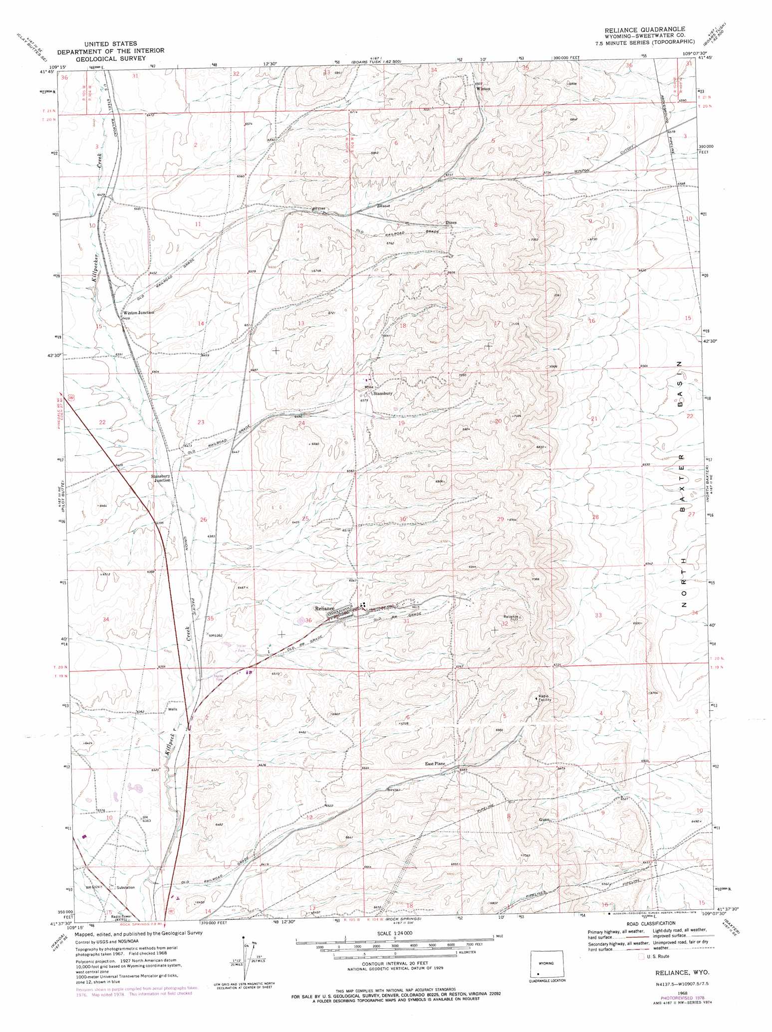
USGS Topo Quad 41109f2 - 1:24,000 scale
| Topo Map Name: | Reliance |
| USGS Topo Quad ID: | 41109f2 |
| Print Size: | ca. 21 1/4" wide x 27" high |
| Southeast Coordinates: | 41.625° N latitude / 109.125° W longitude |
| Map Center Coordinates: | 41.6875° N latitude / 109.1875° W longitude |
| U.S. State: | WY |
| Filename: | o41109f2.jpg |
| Download Map JPG Image: | Reliance topo map 1:24,000 scale |
| Map Type: | Topographic |
| Topo Series: | 7.5´ |
| Map Scale: | 1:24,000 |
| Source of Map Images: | United States Geological Survey (USGS) |
| Alternate Map Versions: |
Reliance WY 1968, updated 1972 Download PDF Buy paper map Reliance WY 2012 Download PDF Buy paper map Reliance WY 2015 Download PDF Buy paper map |
1:24,000 Topo Quads surrounding Reliance
Clay Buttes |
White Rocks |
Boars Tusk |
North Table Mountain |
Steamboat Mountain |
Clay Buttes Sw |
Clay Buttes Se |
Boars Tusk Sw |
Deer Butte |
South Superior |
Scott Spring |
Pilot Butte |
Reliance |
North Baxter |
Thayer Junction |
Green River |
Kanda |
Rock Springs |
Baxter |
Point Of Rocks Sw |
Whalen Butte |
Wilkins Peak |
Kappes Canyon |
Lion Bluffs |
Camel Rock |
> Back to 41109e1 at 1:100,000 scale
> Back to 41108a1 at 1:250,000 scale
> Back to U.S. Topo Maps home
Reliance topo map: Gazetteer
Reliance: Dams
Number 1 Tailings Pond Dam elevation 2024m 6640′Reliance: Mines
Dines Number Eight Mine elevation 2098m 6883′Dines Number Eleven Mine elevation 2112m 6929′
Dines Number Nine Mine elevation 2138m 7014′
Dines Number Six Mine elevation 2077m 6814′
Dines Number Ten Mine elevation 2122m 6961′
E-Plane Number Eleven Mine elevation 2051m 6729′
Gunn-Quealy B Mine elevation 2129m 6984′
Gunn-Quealy C Mine elevation 2099m 6886′
Hopeful Mine elevation 2087m 6847′
MO Nine Mine elevation 2136m 7007′
Reliance Number Eleven Mine elevation 2046m 6712′
Reliance Number Five Mine elevation 2000m 6561′
Reliance Number One A Mine elevation 2031m 6663′
Reliance Number One B Mine elevation 2027m 6650′
Reliance Number One C Mine elevation 2065m 6774′
Reliance Number One Mine elevation 2082m 6830′
Reliance Number Seven Mine elevation 2066m 6778′
Reliance Number Three Mine elevation 2015m 6610′
Reliance Pit Number Eleven elevation 2021m 6630′
Reliance Pit Number Four elevation 2107m 6912′
Reliance Pit Number One Mine elevation 2095m 6873′
Reliance Pit Number Ten elevation 2122m 6961′
Reliance Pit Number Three elevation 2066m 6778′
Reliance Pit Number Three A elevation 2028m 6653′
Reliance Pit Number Twelve elevation 2006m 6581′
Reliance Pit Number Two elevation 2027m 6650′
Rock Springs Number Eleven Mine elevation 2064m 6771′
Rock Springs Number Two B Mine elevation 2068m 6784′
Routh Pit Number Two and Three elevation 1993m 6538′
Stansbury Mine elevation 2016m 6614′
Stansbury Number One Mine elevation 2015m 6610′
Stansbury Number Three Mine elevation 2101m 6893′
Winton Number One Mine elevation 2168m 7112′
Winton Number Seven A Mine elevation 2112m 6929′
Winton Number Three Mine elevation 2153m 7063′
Reliance: Populated Places
Dines (historical) elevation 2079m 6820′Reliance elevation 1990m 6528′
Stansbury elevation 2030m 6660′
Winton (historical) elevation 2123m 6965′
Reliance: Reservoirs
Number 1 Tailings Pond Reservoir elevation 2024m 6640′Reliance digital topo map on disk
Buy this Reliance topo map showing relief, roads, GPS coordinates and other geographical features, as a high-resolution digital map file on DVD: